Sutton County Sketch File 8
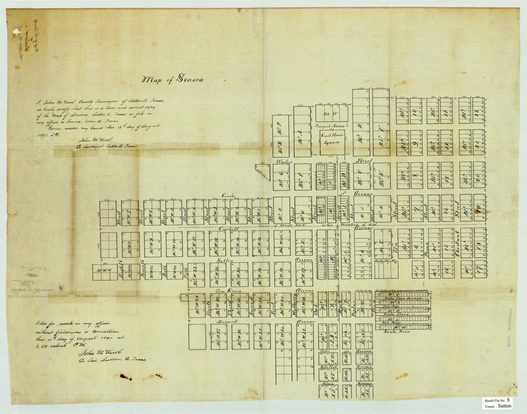
Map of Sonora, Sutton County, Texas
-
Map/Doc
12379
-
Collection
General Map Collection
-
Object Dates
1891/8/12 (Creation Date)
1891/8/11 (File Date)
-
People and Organizations
John McNichol (Surveyor/Engineer)
-
Counties
Sutton
-
Subjects
Surveying Sketch File
-
Height x Width
24.9 x 31.6 inches
63.2 x 80.3 cm
-
Features
Menard Avenue
Wilson Avenue
Camino San Bernardino Street
Santa Rosa Avenue
San Diego Avenue
Santa Clara Avenue
San Jago Avenue
Santa Inez Avenue
Belle View Avenue
Taylor Avenue
Sonora
Tom Green Avenue
Sutton Avenue
Crockett Avenue
Pecan Street
Chestnut Street
Water Street
Concho Avenue
Court House Square
Prospect Avenue
Part of: General Map Collection
Crockett County Rolled Sketch 76

Print $20.00
- Digital $50.00
Crockett County Rolled Sketch 76
1950
Size 24.6 x 26.1 inches
Map/Doc 5617
Kent County Working Sketch 3b

Print $20.00
- Digital $50.00
Kent County Working Sketch 3b
1948
Size 24.9 x 23.3 inches
Map/Doc 70010
Newton County Sketch File 26

Print $4.00
- Digital $50.00
Newton County Sketch File 26
1893
Size 11.2 x 8.8 inches
Map/Doc 32409
Hockley County Boundary File 5

Print $42.00
- Digital $50.00
Hockley County Boundary File 5
Size 6.8 x 5.8 inches
Map/Doc 54829
Grayson County, Fannin District

Print $20.00
- Digital $50.00
Grayson County, Fannin District
1885
Size 39.6 x 35.1 inches
Map/Doc 81942
Sutton County Rolled Sketch 46

Print $20.00
- Digital $50.00
Sutton County Rolled Sketch 46
1929
Size 19.4 x 15.6 inches
Map/Doc 7887
Part of Laguna Madre in Cameron County, showing Subdivision for Mineral Development

Print $20.00
- Digital $50.00
Part of Laguna Madre in Cameron County, showing Subdivision for Mineral Development
1963
Size 45.8 x 36.0 inches
Map/Doc 1926
Brewster County Working Sketch 97

Print $20.00
- Digital $50.00
Brewster County Working Sketch 97
1978
Size 31.7 x 47.0 inches
Map/Doc 67697
Gaines County Rolled Sketch 31

Print $20.00
- Digital $50.00
Gaines County Rolled Sketch 31
1964
Size 20.2 x 25.5 inches
Map/Doc 5944
Proceedings of The International (Water) Boundary Commission United States and Mexico Treaties of 1884 and 1889, Volume 2

Proceedings of The International (Water) Boundary Commission United States and Mexico Treaties of 1884 and 1889, Volume 2
Map/Doc 83145
Montgomery County Rolled Sketch 47

Print $20.00
- Digital $50.00
Montgomery County Rolled Sketch 47
2009
Size 36.5 x 24.6 inches
Map/Doc 89032
Real County Working Sketch 45

Print $20.00
- Digital $50.00
Real County Working Sketch 45
1955
Size 23.1 x 18.5 inches
Map/Doc 71937
You may also like
[Township 3 North, Block 32]
![91218, [Township 3 North, Block 32], Twichell Survey Records](https://historictexasmaps.com/wmedia_w700/maps/91218-1.tif.jpg)
Print $20.00
- Digital $50.00
[Township 3 North, Block 32]
Size 14.4 x 17.8 inches
Map/Doc 91218
Stephens County Sketch File 9a

Print $4.00
- Digital $50.00
Stephens County Sketch File 9a
1884
Size 8.6 x 8.2 inches
Map/Doc 37040
Culberson County Rolled Sketch 39

Print $20.00
- Digital $50.00
Culberson County Rolled Sketch 39
Size 25.6 x 19.3 inches
Map/Doc 5783
Waller County Sketch File 11

Print $40.00
- Digital $50.00
Waller County Sketch File 11
1913
Size 16.6 x 14.3 inches
Map/Doc 39614
Colton's New Map of the State of Texas Compiled from J. De Cordova's Large Map

Print $20.00
- Digital $50.00
Colton's New Map of the State of Texas Compiled from J. De Cordova's Large Map
1858
Size 18.0 x 28.4 inches
Map/Doc 89225
Galveston County Rolled Sketch 16

Print $20.00
- Digital $50.00
Galveston County Rolled Sketch 16
1952
Size 43.6 x 38.0 inches
Map/Doc 9078
Harris County Rolled Sketch HI

Print $20.00
- Digital $50.00
Harris County Rolled Sketch HI
1922
Size 30.9 x 42.0 inches
Map/Doc 9117

Brazoria County Working Sketch 49b

Print $20.00
- Digital $50.00
Brazoria County Working Sketch 49b
2003
Size 34.9 x 35.3 inches
Map/Doc 78348
Hansford County Boundary File 3

Print $10.00
- Digital $50.00
Hansford County Boundary File 3
Size 13.6 x 8.7 inches
Map/Doc 54270
Val Verde County Working Sketch 32

Print $20.00
- Digital $50.00
Val Verde County Working Sketch 32
1938
Size 41.5 x 24.2 inches
Map/Doc 72167
Pecos County Rolled Sketch 91

Print $20.00
- Digital $50.00
Pecos County Rolled Sketch 91
Size 23.6 x 34.7 inches
Map/Doc 9710