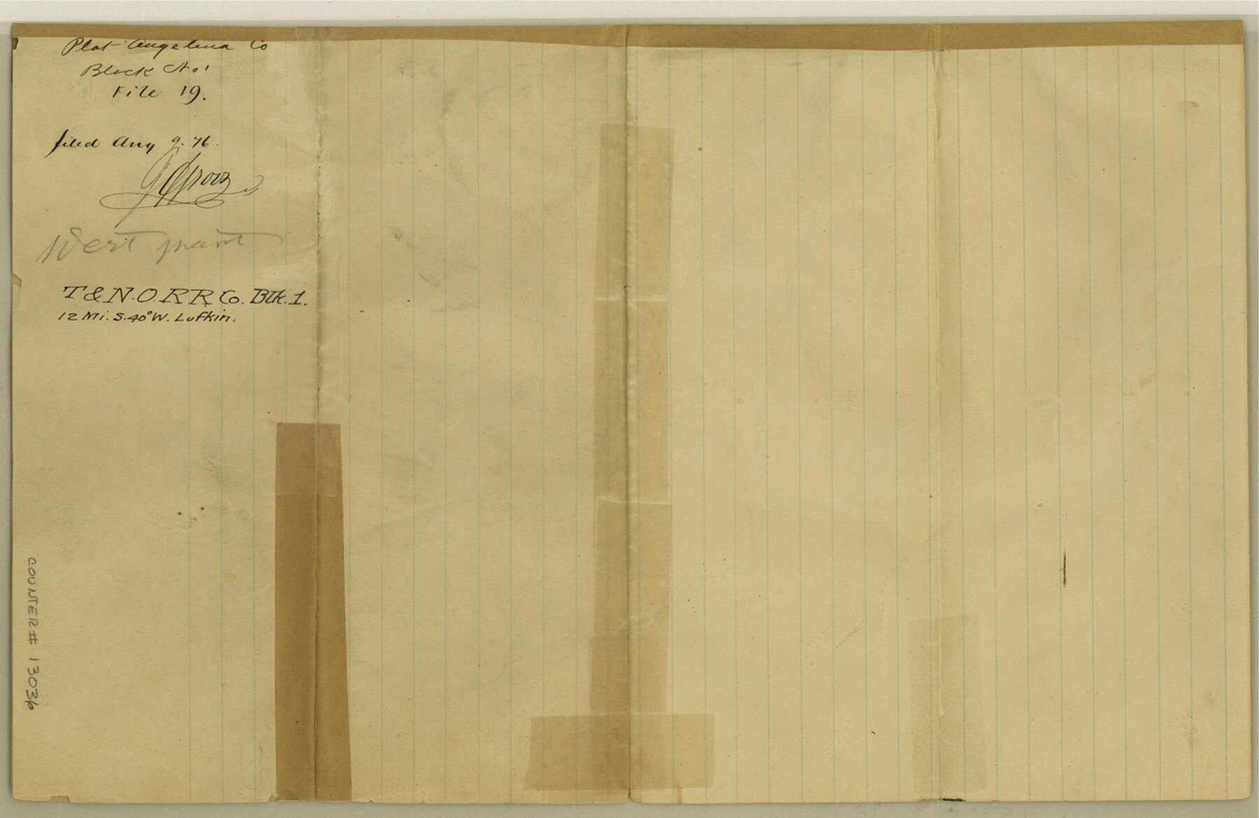
Angelina County Sketch File 19
[Sketch of T. & N. O. R.R. Co. Block 1]
-
Map/Doc
13036
-
Collection
General Map Collection
-
Object Dates
1876/7/7 (Creation Date)
1876/8/9 (File Date)
-
People and Organizations
Jas. D. Gann (Surveyor/Engineer)
-
Counties
Angelina
-
Subjects
Surveying Sketch File
-
Height x Width
8.2 x 12.6 inches
20.8 x 32.0 cm
-
Medium
paper, manuscript
-
Features
Jack Bayou
Part of: General Map Collection
Flight Mission No. CGI-4N, Frame 173, Cameron County

Print $20.00
- Digital $50.00
Flight Mission No. CGI-4N, Frame 173, Cameron County
1955
Size 18.6 x 22.3 inches
Map/Doc 84676
Liberty County Working Sketch 30

Print $20.00
- Digital $50.00
Liberty County Working Sketch 30
1943
Size 18.5 x 20.6 inches
Map/Doc 70489
Bailey County

Print $20.00
- Digital $50.00
Bailey County
1913
Size 29.0 x 22.5 inches
Map/Doc 66708
Tarrant County Sketch File 11

Print $11.00
- Digital $50.00
Tarrant County Sketch File 11
1859
Size 7.5 x 6.2 inches
Map/Doc 37698
Comanche County Sketch File 26

Print $20.00
- Digital $50.00
Comanche County Sketch File 26
Size 18.0 x 17.5 inches
Map/Doc 11144
Right of Way and Track Map, the Missouri, Kansas & Texas Ry. Of Texas operated by the Missouri, Kansas & Texas Ry. Of Texas, Houston Division

Print $40.00
- Digital $50.00
Right of Way and Track Map, the Missouri, Kansas & Texas Ry. Of Texas operated by the Missouri, Kansas & Texas Ry. Of Texas, Houston Division
1918
Size 26.0 x 62.1 inches
Map/Doc 64785
Flight Mission No. CLL-1N, Frame 8, Willacy County

Print $20.00
- Digital $50.00
Flight Mission No. CLL-1N, Frame 8, Willacy County
1954
Size 18.3 x 22.1 inches
Map/Doc 86995
Chambers County Working Sketch 1

Print $20.00
- Digital $50.00
Chambers County Working Sketch 1
1895
Size 29.4 x 24.9 inches
Map/Doc 67984
Jasper County

Print $40.00
- Digital $50.00
Jasper County
1946
Size 48.6 x 42.9 inches
Map/Doc 73192
Terry County Sketch File 9

Print $4.00
- Digital $50.00
Terry County Sketch File 9
1917
Size 14.4 x 8.8 inches
Map/Doc 38032
Callahan County Working Sketch 15

Print $20.00
- Digital $50.00
Callahan County Working Sketch 15
2010
Size 22.6 x 27.3 inches
Map/Doc 89295
Flight Mission No. CGI-3N, Frame 107, Cameron County

Print $20.00
- Digital $50.00
Flight Mission No. CGI-3N, Frame 107, Cameron County
1954
Size 18.6 x 22.3 inches
Map/Doc 84587
You may also like
Rains County Working Sketch 6

Print $20.00
- Digital $50.00
Rains County Working Sketch 6
1958
Size 26.4 x 42.3 inches
Map/Doc 71832
Flight Mission No. CRC-3R, Frame 35, Chambers County

Print $20.00
- Digital $50.00
Flight Mission No. CRC-3R, Frame 35, Chambers County
1956
Size 18.5 x 22.2 inches
Map/Doc 84808
Pecos County Rolled Sketch 93

Print $40.00
- Digital $50.00
Pecos County Rolled Sketch 93
Size 50.3 x 42.8 inches
Map/Doc 9711
Bexar County Working Sketch 3

Print $20.00
- Digital $50.00
Bexar County Working Sketch 3
1941
Size 19.6 x 21.6 inches
Map/Doc 67319
Sutton County Rolled Sketch 59

Print $40.00
- Digital $50.00
Sutton County Rolled Sketch 59
1960
Size 86.1 x 42.5 inches
Map/Doc 9977
Duval County Sketch File 80

Print $32.00
- Digital $50.00
Duval County Sketch File 80
Size 14.1 x 8.9 inches
Map/Doc 21492
Map of the State of Texas

Print $40.00
- Digital $50.00
Map of the State of Texas
1879
Size 102.3 x 106.1 inches
Map/Doc 16974
Marion County Working Sketch 34

Print $20.00
- Digital $50.00
Marion County Working Sketch 34
1983
Size 45.2 x 23.2 inches
Map/Doc 70810
Reagan County Working Sketch 3

Print $40.00
- Digital $50.00
Reagan County Working Sketch 3
1923
Size 42.6 x 54.3 inches
Map/Doc 71843
Ellwood Farms Situated in Hockley, Lamb, and Hale Counties, Texas

Print $20.00
- Digital $50.00
Ellwood Farms Situated in Hockley, Lamb, and Hale Counties, Texas
Size 20.3 x 30.1 inches
Map/Doc 92229
[Survey 9, Block 9 Potter and Randall]
![91721, [Survey 9, Block 9 Potter and Randall], Twichell Survey Records](https://historictexasmaps.com/wmedia_w700/maps/91721-1.tif.jpg)
Print $20.00
- Digital $50.00
[Survey 9, Block 9 Potter and Randall]
Size 22.1 x 15.9 inches
Map/Doc 91721
Old Miscellaneous File 23

Print $58.00
- Digital $50.00
Old Miscellaneous File 23
1919
Size 14.2 x 8.6 inches
Map/Doc 75600