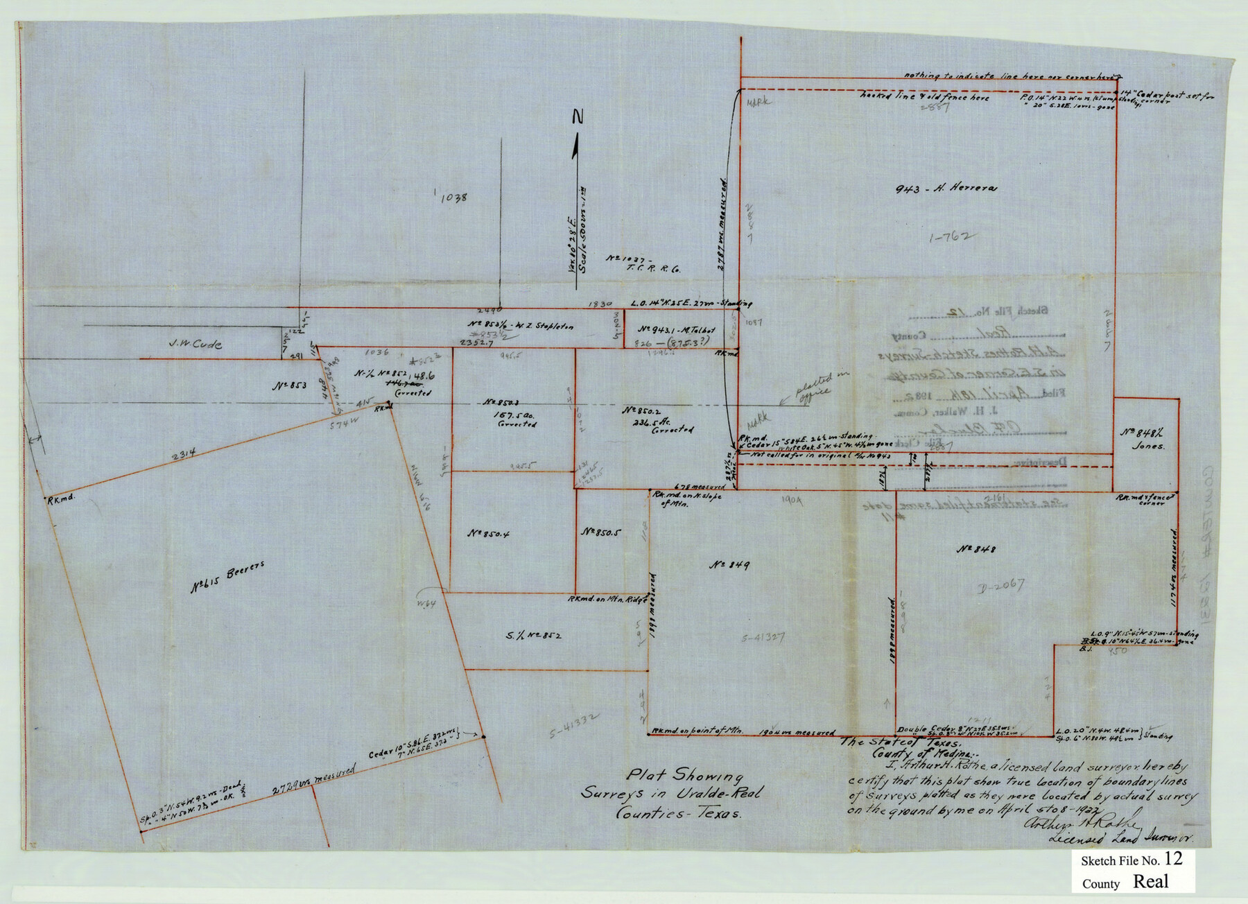
Real County Sketch File 12
[Plat showing surveys in Uvalde, Real, and Bandera Counties in the SE corner of Real County]
-
Map/Doc
12231
-
Collection
General Map Collection
-
Object Dates
1932 (Creation Date)
4/18/1932 (File Date)
4/5-4/8 1932 (Survey Date)
-
People and Organizations
Arthur H. Rothe (Surveyor/Engineer)
-
Counties
Real Uvalde Bandera
-
Subjects
Surveying Sketch File
-
Height x Width
13.9 x 19.2 inches
35.3 x 48.8 cm
-
Medium
paper, manuscript
-
Comments
See Real County Sketch File 11 (35065) for surveyor's statement.
Related maps
Real County Sketch File 10

Print $6.00
- Digital $50.00
Real County Sketch File 10
1932
Size 10.3 x 15.0 inches
Map/Doc 35063
Real County Sketch File 11

Print $8.00
- Digital $50.00
Real County Sketch File 11
1932
Size 11.2 x 8.8 inches
Map/Doc 35065
Part of: General Map Collection
Brooks County Working Sketch Graphic Index

Print $20.00
- Digital $50.00
Brooks County Working Sketch Graphic Index
1955
Size 41.3 x 33.6 inches
Map/Doc 76479
[Ft. W. & R. G. Ry. Right of Way Map, Chapin to Bluffdale, Hood County, Texas]
![64644, [Ft. W. & R. G. Ry. Right of Way Map, Chapin to Bluffdale, Hood County, Texas], General Map Collection](https://historictexasmaps.com/wmedia_w700/maps/64644.tif.jpg)
Print $40.00
- Digital $50.00
[Ft. W. & R. G. Ry. Right of Way Map, Chapin to Bluffdale, Hood County, Texas]
1918
Size 37.7 x 84.3 inches
Map/Doc 64644
Cherokee County Working Sketch 22

Print $20.00
- Digital $50.00
Cherokee County Working Sketch 22
1972
Size 24.0 x 19.2 inches
Map/Doc 67977
San Patricio County NRC Article 33.136 Sketch 7

Print $40.00
- Digital $50.00
San Patricio County NRC Article 33.136 Sketch 7
2014
Size 22.2 x 33.8 inches
Map/Doc 94691

FT. W. & R. G. Ry. Right of Way Map, Winchell to Brady, McCulloch County, Texas

Print $40.00
- Digital $50.00
FT. W. & R. G. Ry. Right of Way Map, Winchell to Brady, McCulloch County, Texas
1918
Size 38.0 x 121.9 inches
Map/Doc 61410
Kimble County Working Sketch 16

Print $20.00
- Digital $50.00
Kimble County Working Sketch 16
1923
Size 22.9 x 17.1 inches
Map/Doc 70084
Travis County Boundary File 29

Print $4.00
- Digital $50.00
Travis County Boundary File 29
Size 13.2 x 8.4 inches
Map/Doc 59467

Panola County Sketch File 11

Print $6.00
- Digital $50.00
Panola County Sketch File 11
1872
Size 10.3 x 13.2 inches
Map/Doc 33467
Grimes County Working Sketch 2

Print $20.00
- Digital $50.00
Grimes County Working Sketch 2
1941
Size 13.2 x 20.9 inches
Map/Doc 63293
Jim Wells County Boundary File 1

Print $22.00
- Digital $50.00
Jim Wells County Boundary File 1
Size 8.9 x 4.3 inches
Map/Doc 55531
You may also like
Zapata County Rolled Sketch 16

Print $20.00
- Digital $50.00
Zapata County Rolled Sketch 16
1940
Size 30.3 x 19.4 inches
Map/Doc 8314
Brazoria County Working Sketch 17

Print $20.00
- Digital $50.00
Brazoria County Working Sketch 17
1948
Size 17.0 x 19.0 inches
Map/Doc 67502
[Triangulation Sketch]
![89815, [Triangulation Sketch], Twichell Survey Records](https://historictexasmaps.com/wmedia_w700/maps/89815-1.tif.jpg)
Print $40.00
- Digital $50.00
[Triangulation Sketch]
Size 56.0 x 38.0 inches
Map/Doc 89815
Van Zandt County Sketch File 11

Print $4.00
- Digital $50.00
Van Zandt County Sketch File 11
1858
Size 10.2 x 8.1 inches
Map/Doc 39397
General Highway Map, Chambers County, Texas

Print $20.00
General Highway Map, Chambers County, Texas
1961
Size 18.3 x 24.8 inches
Map/Doc 79404
Harris County Sketch File 53

Print $20.00
- Digital $50.00
Harris County Sketch File 53
1914
Size 15.9 x 12.0 inches
Map/Doc 11654
Taylor County Rolled Sketch 20

Print $20.00
- Digital $50.00
Taylor County Rolled Sketch 20
Size 25.6 x 33.9 inches
Map/Doc 7914
Henderson County

Print $40.00
- Digital $50.00
Henderson County
1988
Size 34.6 x 68.7 inches
Map/Doc 73178
Austin County Working Sketch 2

Print $20.00
- Digital $50.00
Austin County Working Sketch 2
1944
Size 23.3 x 27.0 inches
Map/Doc 67243
Edwards County Working Sketch 29

Print $40.00
- Digital $50.00
Edwards County Working Sketch 29
1946
Size 44.9 x 53.9 inches
Map/Doc 68905
Jeff Davis County Sketch File 11

Print $20.00
- Digital $50.00
Jeff Davis County Sketch File 11
Size 17.7 x 29.9 inches
Map/Doc 11858
