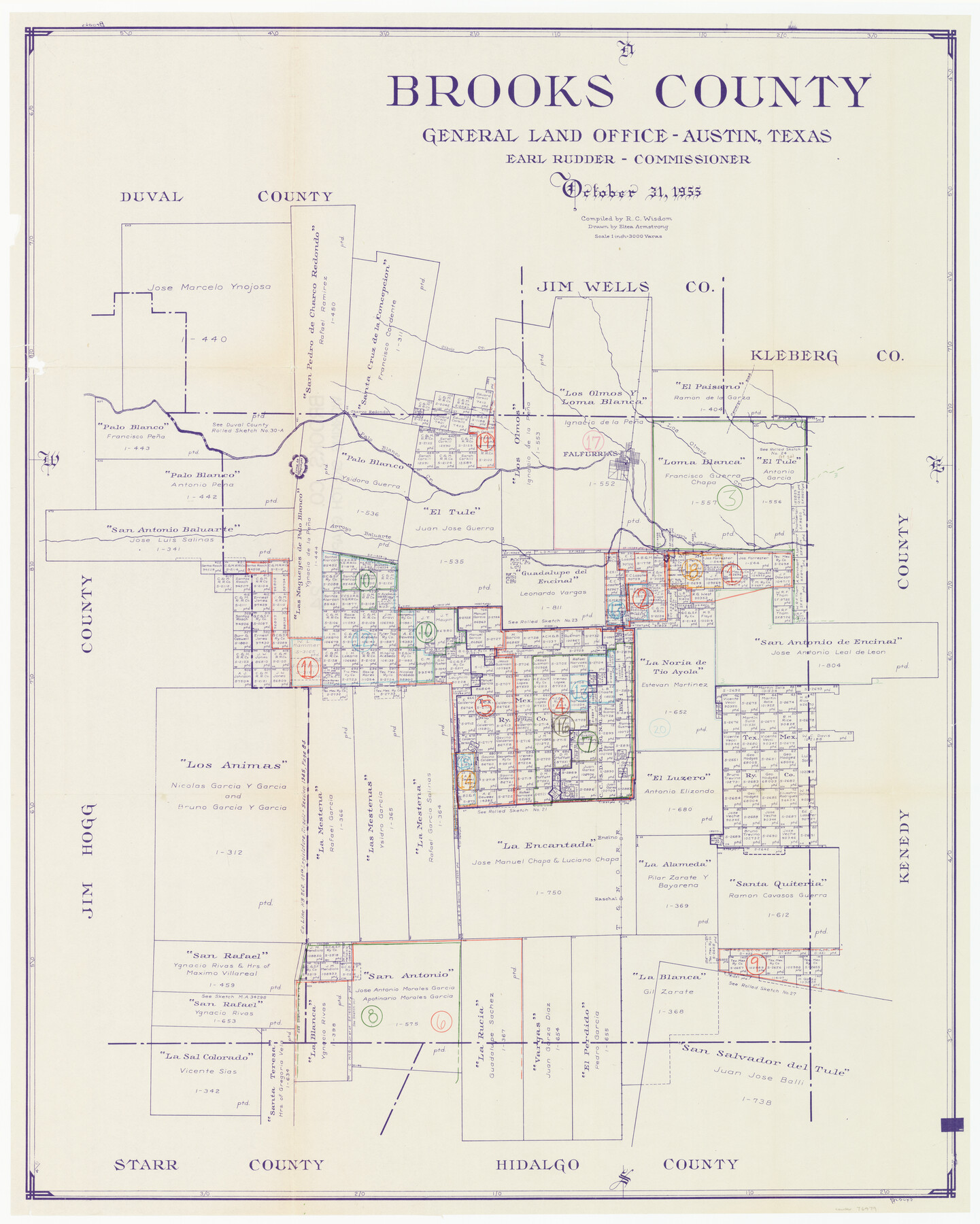
Brooks County Working Sketch Graphic Index
-
Map/Doc
76479
-
Collection
General Map Collection
-
Object Dates
1955/10/31 (Creation Date)
-
People and Organizations
R.C. Wisdom (Compiler)
Eltea Armstrong (Draftsman)
-
Counties
Brooks
-
Subjects
County Surveying Working Sketch
-
Height x Width
41.3 x 33.6 inches
104.9 x 85.3 cm
-
Scale
1" = 3000 varas
Part of: General Map Collection
Pecos County Rolled Sketch 132

Print $20.00
- Digital $50.00
Pecos County Rolled Sketch 132
Size 32.8 x 38.9 inches
Map/Doc 9728
Panola County

Print $20.00
- Digital $50.00
Panola County
1947
Size 41.7 x 41.3 inches
Map/Doc 95607
Flight Mission No. BQR-7K, Frame 31, Brazoria County

Print $20.00
- Digital $50.00
Flight Mission No. BQR-7K, Frame 31, Brazoria County
1952
Size 18.6 x 22.1 inches
Map/Doc 84029
Crosby County Sketch File A

Print $6.00
- Digital $50.00
Crosby County Sketch File A
Size 15.2 x 11.7 inches
Map/Doc 19989
Runnels County Rolled Sketch 46

Print $20.00
- Digital $50.00
Runnels County Rolled Sketch 46
1954
Size 32.3 x 38.5 inches
Map/Doc 10622
Sketch D Showing the progress of Section IV 1845 to 1852

Print $20.00
- Digital $50.00
Sketch D Showing the progress of Section IV 1845 to 1852
1852
Size 22.8 x 13.0 inches
Map/Doc 97208
The Western Coast of Louisiana and The Coast of New Leon

Print $20.00
- Digital $50.00
The Western Coast of Louisiana and The Coast of New Leon
1775
Size 21.1 x 28.7 inches
Map/Doc 93705
Harrison County

Print $20.00
- Digital $50.00
Harrison County
1920
Size 43.0 x 40.0 inches
Map/Doc 77305
Flight Mission No. DAG-24K, Frame 149, Matagorda County

Print $20.00
- Digital $50.00
Flight Mission No. DAG-24K, Frame 149, Matagorda County
1953
Size 18.4 x 16.2 inches
Map/Doc 86563
Presidio County Working Sketch 9

Print $20.00
- Digital $50.00
Presidio County Working Sketch 9
1928
Size 40.7 x 18.5 inches
Map/Doc 71683
Lynn County Boundary File 4a

Print $6.00
- Digital $50.00
Lynn County Boundary File 4a
Size 14.3 x 8.8 inches
Map/Doc 56627
Jeff Davis County Rolled Sketch 16

Print $20.00
- Digital $50.00
Jeff Davis County Rolled Sketch 16
Size 27.1 x 31.7 inches
Map/Doc 6369
You may also like
Crosby County Sketch File 23

Print $20.00
- Digital $50.00
Crosby County Sketch File 23
1913
Size 15.0 x 27.2 inches
Map/Doc 11254
Nueces County Rolled Sketch 96

Print $44.00
Nueces County Rolled Sketch 96
1983
Size 24.2 x 36.5 inches
Map/Doc 7053
McLennan County Sketch File 21

Print $4.00
- Digital $50.00
McLennan County Sketch File 21
Size 9.0 x 8.2 inches
Map/Doc 31294
Kerr County Working Sketch 32

Print $20.00
- Digital $50.00
Kerr County Working Sketch 32
1975
Size 33.8 x 25.3 inches
Map/Doc 70063
Edwards County Working Sketch 3

Print $20.00
- Digital $50.00
Edwards County Working Sketch 3
Size 22.6 x 18.3 inches
Map/Doc 68879
Motley County Working Sketch 4

Print $20.00
- Digital $50.00
Motley County Working Sketch 4
1914
Size 19.9 x 10.2 inches
Map/Doc 71209
Fannin County

Print $20.00
- Digital $50.00
Fannin County
1946
Size 40.6 x 35.4 inches
Map/Doc 77277
Duval County Sketch File 55

Print $20.00
- Digital $50.00
Duval County Sketch File 55
1937
Size 22.3 x 17.1 inches
Map/Doc 11404
[Part of T. & N. O. RR. Co Block 2 and area around Jasper Hays survey]
![90850, [Part of T. & N. O. RR. Co Block 2 and area around Jasper Hays survey], Twichell Survey Records](https://historictexasmaps.com/wmedia_w700/maps/90850-2.tif.jpg)
Print $20.00
- Digital $50.00
[Part of T. & N. O. RR. Co Block 2 and area around Jasper Hays survey]
1907
Size 13.3 x 28.4 inches
Map/Doc 90850
Flight Mission No. CRC-4R, Frame 79, Chambers County

Print $20.00
- Digital $50.00
Flight Mission No. CRC-4R, Frame 79, Chambers County
1956
Size 18.9 x 22.6 inches
Map/Doc 84883
Map of Somervell County

Print $20.00
- Digital $50.00
Map of Somervell County
1875
Size 21.0 x 22.0 inches
Map/Doc 4043
Liberty County Sketch File 56

Print $20.00
- Digital $50.00
Liberty County Sketch File 56
Size 11.9 x 18.7 inches
Map/Doc 11996