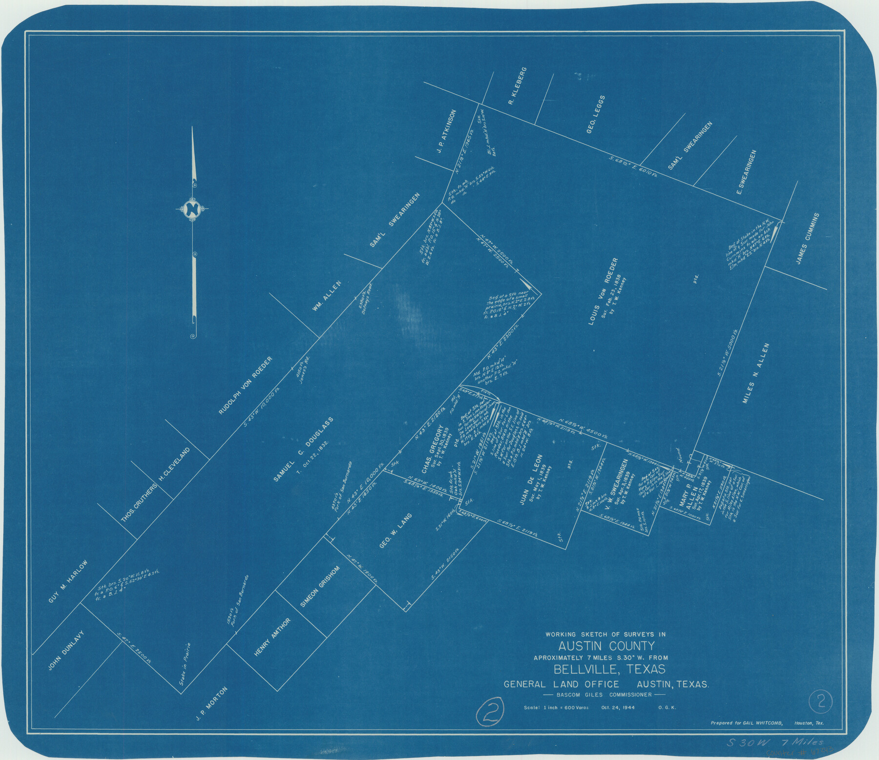
Austin County Working Sketch 2
-
Map/Doc
67243
-
Collection
General Map Collection
-
Object Dates
10/24/1944 (Creation Date)
-
People and Organizations
Bascom Giles (GLO Commissioner)
Otto G. Kurio (Draftsman)
-
Counties
Austin
-
Subjects
Surveying Working Sketch
-
Height x Width
23.3 x 27.0 inches
59.2 x 68.6 cm
-
Scale
1" = 600 varas
-
Comments
Surveys located about seven miles South 30 degrees West of Bellville, Texas.
Part of: General Map Collection

Castro County Sketch File 1a

Print $8.00
- Digital $50.00
Castro County Sketch File 1a
Size 8.6 x 14.0 inches
Map/Doc 17454
Texas-United States Boundary Line 3

Print $40.00
- Digital $50.00
Texas-United States Boundary Line 3
Size 54.6 x 10.5 inches
Map/Doc 74979
Sketch No. 2 Showing Land Ties with Houston & Texas Central Rail Road through Harris County, Texas

Print $20.00
- Digital $50.00
Sketch No. 2 Showing Land Ties with Houston & Texas Central Rail Road through Harris County, Texas
1880
Size 8.5 x 26.9 inches
Map/Doc 64496
Nolan County Sketch File D1

Print $42.00
- Digital $50.00
Nolan County Sketch File D1
1904
Size 19.5 x 18.8 inches
Map/Doc 42173
Edwards County Sketch File 42

Print $20.00
- Digital $50.00
Edwards County Sketch File 42
1947
Size 17.9 x 22.7 inches
Map/Doc 11440
Maps of Gulf Intracoastal Waterway, Texas - Sabine River to the Rio Grande and connecting waterways including ship channels

Print $20.00
- Digital $50.00
Maps of Gulf Intracoastal Waterway, Texas - Sabine River to the Rio Grande and connecting waterways including ship channels
1966
Size 14.6 x 22.2 inches
Map/Doc 61975
Real County Working Sketch 73

Print $20.00
- Digital $50.00
Real County Working Sketch 73
1978
Size 28.2 x 24.9 inches
Map/Doc 71965
Presidio County Rolled Sketch 106

Print $20.00
- Digital $50.00
Presidio County Rolled Sketch 106
1955
Size 23.0 x 36.4 inches
Map/Doc 7387
Dimmit County Working Sketch 55

Print $20.00
- Digital $50.00
Dimmit County Working Sketch 55
1996
Size 33.7 x 34.3 inches
Map/Doc 68716
Yoakum County Sketch File 20

Print $22.00
- Digital $50.00
Yoakum County Sketch File 20
1977
Size 13.1 x 14.5 inches
Map/Doc 40841
Live Oak County Boundary File 60b

Print $10.00
- Digital $50.00
Live Oak County Boundary File 60b
Size 12.8 x 8.3 inches
Map/Doc 56416
You may also like
Travis County Rolled Sketch 21

Print $20.00
- Digital $50.00
Travis County Rolled Sketch 21
1941
Size 16.2 x 14.7 inches
Map/Doc 8022
Flight Mission No. DQO-6K, Frame 33, Galveston County

Print $20.00
- Digital $50.00
Flight Mission No. DQO-6K, Frame 33, Galveston County
1952
Size 18.8 x 22.4 inches
Map/Doc 85099
Louisiana and Texas Intracoastal Waterway

Print $20.00
- Digital $50.00
Louisiana and Texas Intracoastal Waterway
1929
Size 13.8 x 19.7 inches
Map/Doc 83340
Nueces County Rolled Sketch 106

Print $104.00
Nueces County Rolled Sketch 106
1986
Size 18.2 x 24.6 inches
Map/Doc 7097
Galveston County NRC Article 33.136 Sketch 78

Print $24.00
- Digital $50.00
Galveston County NRC Article 33.136 Sketch 78
2015
Size 36.0 x 24.0 inches
Map/Doc 95129
Stonewall County Sketch File 10

Print $10.00
- Digital $50.00
Stonewall County Sketch File 10
1899
Size 11.2 x 8.6 inches
Map/Doc 37232
Milam County Boundary File 5b

Print $20.00
- Digital $50.00
Milam County Boundary File 5b
Size 22.6 x 37.8 inches
Map/Doc 57239
The Republic County of Jackson. Boundaries Defined, December 29, 1837

Print $20.00
The Republic County of Jackson. Boundaries Defined, December 29, 1837
2020
Size 15.6 x 21.8 inches
Map/Doc 96184
[George Gentry, Wm. Williams, and surrounding surveys]
![90973, [George Gentry, Wm. Williams, and surrounding surveys], Twichell Survey Records](https://historictexasmaps.com/wmedia_w700/maps/90973-1.tif.jpg)
Print $2.00
- Digital $50.00
[George Gentry, Wm. Williams, and surrounding surveys]
Size 8.3 x 12.6 inches
Map/Doc 90973
Harris County Boundary File 39a

Print $12.00
- Digital $50.00
Harris County Boundary File 39a
Size 10.1 x 8.0 inches
Map/Doc 54329

Flight Mission No. BRA-6M, Frame 151, Jefferson County

Print $20.00
- Digital $50.00
Flight Mission No. BRA-6M, Frame 151, Jefferson County
1953
Size 18.6 x 22.1 inches
Map/Doc 85452