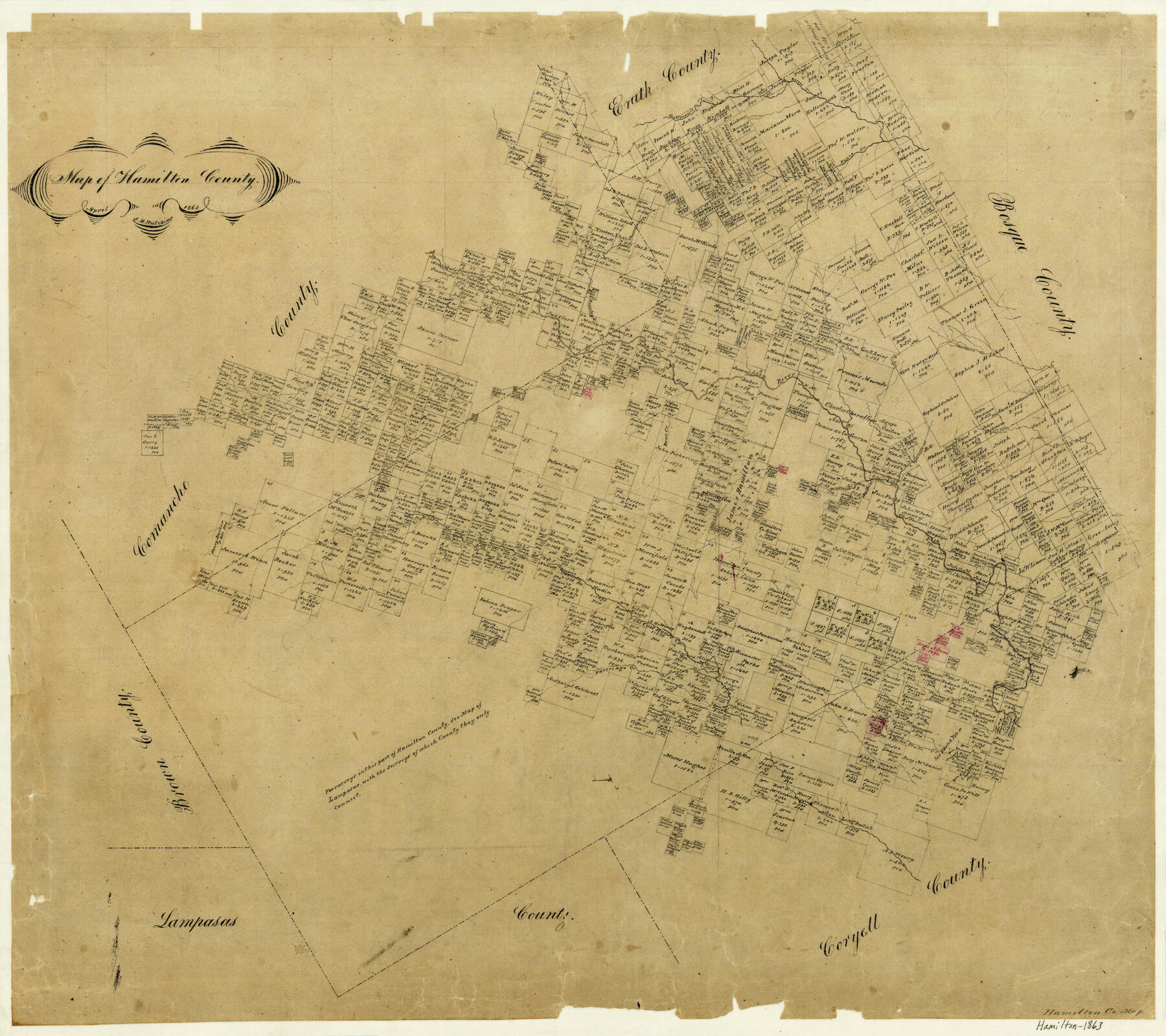
Map of Hamilton County
-
Map/Doc
3621
-
Collection
General Map Collection
-
Object Dates
4/1863 (Creation Date)
-
People and Organizations
J.H. Hutchins (Draftsman)
-
Counties
Hamilton
-
Subjects
County
-
Height x Width
22.8 x 25.8 inches
57.9 x 65.5 cm
-
Features
Alexander Creek
Partridge Creek
Cow House Creek
Plum Creek
Eagle Creek
Sycamore Creek
Merader Creek
Comanche Creek
Bear Creek
Gillmoor's Creek
Thompson's Creek
Ressley's Creek
Warring's Creek
Leon River
Meridian Creek
Honey Creek
Bosque Creek
Part of: General Map Collection

Uvalde County Sketch File 15

Print $6.00
- Digital $50.00
Uvalde County Sketch File 15
1849
Size 8.8 x 11.5 inches
Map/Doc 38985
Travis County State Real Property Sketch 15

Print $20.00
- Digital $50.00
Travis County State Real Property Sketch 15
1995
Size 29.6 x 29.5 inches
Map/Doc 61674
Terry County Sketch File 17

Print $5.00
- Digital $50.00
Terry County Sketch File 17
1956
Size 27.7 x 24.7 inches
Map/Doc 12429
Erath County Working Sketch 10

Print $20.00
- Digital $50.00
Erath County Working Sketch 10
1948
Size 28.7 x 24.5 inches
Map/Doc 69091
Right-of-Way and Track Map, Texas State Railroad operated by the T. and N. O. R.R. Co.

Print $40.00
- Digital $50.00
Right-of-Way and Track Map, Texas State Railroad operated by the T. and N. O. R.R. Co.
1917
Size 24.3 x 55.7 inches
Map/Doc 64176
Presidio County Sketch File 116A

Print $63.00
- Digital $50.00
Presidio County Sketch File 116A
Size 17.0 x 11.0 inches
Map/Doc 34885
Cottle County Rolled Sketch 11

Print $20.00
- Digital $50.00
Cottle County Rolled Sketch 11
1927
Size 31.6 x 24.1 inches
Map/Doc 5568
[Map of Lynn County]
![4586, [Map of Lynn County], General Map Collection](https://historictexasmaps.com/wmedia_w700/maps/4586-1.tif.jpg)
Print $20.00
- Digital $50.00
[Map of Lynn County]
Size 22.4 x 17.8 inches
Map/Doc 4586
Terrell County Working Sketch 79

Print $40.00
- Digital $50.00
Terrell County Working Sketch 79
1983
Size 43.0 x 55.8 inches
Map/Doc 69600
Texas Gulf Coast Map from the Sabine River to the Rio Grande as subdivided for mineral development

Print $40.00
- Digital $50.00
Texas Gulf Coast Map from the Sabine River to the Rio Grande as subdivided for mineral development
Size 117.9 x 46.0 inches
Map/Doc 2902
Brazoria County Working Sketch 11

Print $20.00
- Digital $50.00
Brazoria County Working Sketch 11
1935
Size 18.1 x 24.3 inches
Map/Doc 67496
You may also like
Nueces County Sketch File 12b

Print $8.00
- Digital $50.00
Nueces County Sketch File 12b
1889
Size 14.2 x 8.8 inches
Map/Doc 32530
Madison County

Print $20.00
- Digital $50.00
Madison County
1871
Size 15.2 x 20.3 inches
Map/Doc 4587
Flight Mission No. CGI-3N, Frame 169, Cameron County

Print $20.00
- Digital $50.00
Flight Mission No. CGI-3N, Frame 169, Cameron County
1954
Size 18.6 x 22.3 inches
Map/Doc 84633
Trinity River, Balltown Sheet/Pilot Grove Creek

Print $20.00
- Digital $50.00
Trinity River, Balltown Sheet/Pilot Grove Creek
1916
Size 36.9 x 27.5 inches
Map/Doc 65195
[Neches River Bed, Plat and Calculations]
![77101, [Neches River Bed, Plat and Calculations], General Map Collection](https://historictexasmaps.com/wmedia_w700/maps/77101.tif.jpg)
Print $20.00
- Digital $50.00
[Neches River Bed, Plat and Calculations]
1928
Size 23.2 x 19.8 inches
Map/Doc 77101
Hardeman County Sketch File 9

Print $20.00
- Digital $50.00
Hardeman County Sketch File 9
1884
Size 27.7 x 30.1 inches
Map/Doc 11624
Lynn County Rolled Sketch S

Print $20.00
- Digital $50.00
Lynn County Rolled Sketch S
Size 21.1 x 38.7 inches
Map/Doc 6654
Map of the City of Galveston, Texas

Print $20.00
- Digital $50.00
Map of the City of Galveston, Texas
1904
Size 32.0 x 44.0 inches
Map/Doc 73629
Cochran County

Print $20.00
- Digital $50.00
Cochran County
1946
Size 33.2 x 25.0 inches
Map/Doc 1801
Brewster County Working Sketch 36

Print $20.00
- Digital $50.00
Brewster County Working Sketch 36
1944
Size 22.7 x 42.3 inches
Map/Doc 67570
Lynn County Sketch File 18

Print $4.00
- Digital $50.00
Lynn County Sketch File 18
1940
Size 11.2 x 8.8 inches
Map/Doc 30514
Jefferson County Rolled Sketch 41

Print $20.00
- Digital $50.00
Jefferson County Rolled Sketch 41
1897
Size 25.1 x 17.8 inches
Map/Doc 6399