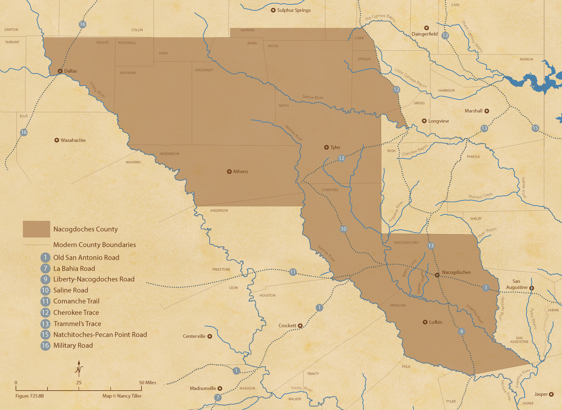
The Republic County of Nacogdoches. January 16, 1843
Figure No. 725.8 from 'A Boundary Atlas of Texas, 1821-1845' by Jim Tiller
-
Map/Doc
96249
-
Collection
Nancy and Jim Tiller Digital Collection
-
Object Dates
2020/1/1 (Creation Date)
-
People and Organizations
Jim Tiller (Author)
Nancy Tiller (Cartographer)
Gang Gong (GIS Professional)
-
Counties
Nacogdoches
-
Subjects
Atlas County Republic of Texas Texas Boundaries
-
Height x Width
15.9 x 21.8 inches
40.4 x 55.4 cm
-
Medium
digital image
-
Comments
To purchase a digital PDF copy of "A Boundary Atlas of Texas, 1821-1845" see 96437.
Part of: Nancy and Jim Tiller Digital Collection
The Chief Justice County of San Patricio. Proposed, No Date

Print $20.00
The Chief Justice County of San Patricio. Proposed, No Date
2020
Size 20.0 x 21.7 inches
Map/Doc 96072
The Judicial District/County of Panola. Created, January 30, 1841

Print $20.00
The Judicial District/County of Panola. Created, January 30, 1841
2020
Size 19.3 x 21.6 inches
Map/Doc 96340
The Republic County of Washington. Boundaries Defined, December 14, 1837

Print $20.00
The Republic County of Washington. Boundaries Defined, December 14, 1837
2020
Size 20.3 x 21.7 inches
Map/Doc 96302
The Republic County of Shelby. February 1, 1842

Print $20.00
The Republic County of Shelby. February 1, 1842
2020
Size 20.0 x 21.7 inches
Map/Doc 96283
The Republic County of Austin. February 1, 1844

Print $20.00
The Republic County of Austin. February 1, 1844
2020
Size 14.7 x 21.7 inches
Map/Doc 96087
From Citizens Living in Washington County for the Creation of a New County to be Called Washington, Undated

Print $20.00
From Citizens Living in Washington County for the Creation of a New County to be Called Washington, Undated
2020
Size 17.0 x 21.7 inches
Map/Doc 96406
The Republic County of Bexar. December 2, 1841

Print $20.00
The Republic County of Bexar. December 2, 1841
2020
Size 14.8 x 21.7 inches
Map/Doc 96098
From Citizens of Nacogdoches County to Redefine the Boundaries of Nacogdoches County, December 2, 1841

Print $20.00
From Citizens of Nacogdoches County to Redefine the Boundaries of Nacogdoches County, December 2, 1841
2020
Size 22.5 x 21.7 inches
Map/Doc 96395
The Republic County of Washington. December 29, 1845

Print $20.00
The Republic County of Washington. December 29, 1845
2020
Size 11.8 x 21.7 inches
Map/Doc 96310
The Republic County of Milam. January 29, 1842

Print $20.00
The Republic County of Milam. January 29, 1842
2020
Size 17.4 x 21.6 inches
Map/Doc 96231
Wilson Empresario Colony. May 27, 1826

Print $20.00
Wilson Empresario Colony. May 27, 1826
2020
Size 19.4 x 21.6 inches
Map/Doc 96010
The Republic County of Matagorda. January 19, 1841

Print $20.00
The Republic County of Matagorda. January 19, 1841
2020
Size 21.0 x 21.7 inches
Map/Doc 96220
You may also like
Angelina County Working Sketch 20

Print $20.00
- Digital $50.00
Angelina County Working Sketch 20
1955
Size 18.8 x 15.0 inches
Map/Doc 67101
Flight Mission No. DQN-2K, Frame 87, Calhoun County

Print $20.00
- Digital $50.00
Flight Mission No. DQN-2K, Frame 87, Calhoun County
1953
Size 18.9 x 22.6 inches
Map/Doc 84277
Hudspeth County Sketch File 42

Print $12.00
- Digital $50.00
Hudspeth County Sketch File 42
1982
Size 14.2 x 8.7 inches
Map/Doc 27016
Llano County Working Sketch 3

Print $20.00
- Digital $50.00
Llano County Working Sketch 3
1949
Size 23.6 x 24.0 inches
Map/Doc 70621
Flight Mission No. DCL-4C, Frame 147, Kenedy County

Print $20.00
- Digital $50.00
Flight Mission No. DCL-4C, Frame 147, Kenedy County
1943
Size 18.6 x 22.3 inches
Map/Doc 85825
Atascosa County Sketch File 15

Print $6.00
- Digital $50.00
Atascosa County Sketch File 15
1879
Size 7.1 x 13.5 inches
Map/Doc 13775
Harris County Boundary File 39 (22)

Print $40.00
- Digital $50.00
Harris County Boundary File 39 (22)
Size 12.6 x 16.1 inches
Map/Doc 54368
Map of Floyd County

Print $20.00
- Digital $50.00
Map of Floyd County
1888
Size 25.4 x 19.6 inches
Map/Doc 3547
Runnels County

Print $40.00
- Digital $50.00
Runnels County
1948
Size 49.8 x 39.8 inches
Map/Doc 95629
Map in the Southern Portion of Pecos County Texas

Print $40.00
- Digital $50.00
Map in the Southern Portion of Pecos County Texas
1882
Size 64.6 x 21.6 inches
Map/Doc 89692
Cherokee County Sketch File 2

Print $6.00
- Digital $50.00
Cherokee County Sketch File 2
1857
Size 8.2 x 7.9 inches
Map/Doc 18112
Revised Sectional Map No. 4 showing land surveys in the western portion of the county of El Paso, Texas

Print $20.00
- Digital $50.00
Revised Sectional Map No. 4 showing land surveys in the western portion of the county of El Paso, Texas
Size 19.0 x 24.2 inches
Map/Doc 4477