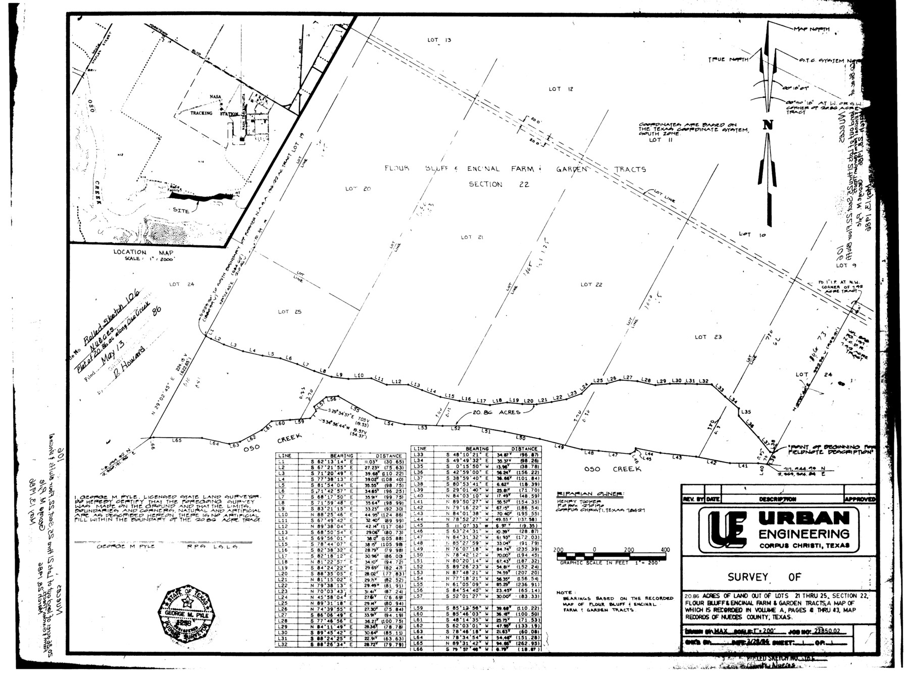
Nueces County Rolled Sketch 106
[Sketch, report, exhibits, and correspondence relating to 20.86 acres of land out of Lots 21 through 25, Section 22, Flour Bluff and Encinal Farm and Garden Tracts]
-
Map/Doc
7097
-
Collection
General Map Collection
-
Object Dates
5/6/1986 (Creation Date)
5/13/1986 (File Date)
-
People and Organizations
George M. Pyle (Surveyor/Engineer)
-
Counties
Nueces
-
Subjects
Surveying Rolled Sketch
-
Height x Width
18.2 x 24.6 inches
46.2 x 62.5 cm
-
Comments
See Nueces County Sketch File 73 (33026) for correspondence related to plat corrections.
Part of: General Map Collection
Hamilton County Working Sketch 9

Print $20.00
- Digital $50.00
Hamilton County Working Sketch 9
1946
Size 31.3 x 24.0 inches
Map/Doc 63347
Hardeman County Working Sketch 14

Print $20.00
- Digital $50.00
Hardeman County Working Sketch 14
Size 30.8 x 42.2 inches
Map/Doc 63395
Hemphill County Sketch File 8

Print $9.00
- Digital $50.00
Hemphill County Sketch File 8
Size 14.3 x 8.9 inches
Map/Doc 26308
Coke County Rolled Sketch 10

Print $20.00
- Digital $50.00
Coke County Rolled Sketch 10
1949
Size 25.3 x 15.0 inches
Map/Doc 5509
McCulloch County Rolled Sketch 2

Digital $50.00
McCulloch County Rolled Sketch 2
Size 81.6 x 30.0 inches
Map/Doc 9496
Nueces County Sketch File 31

Print $8.00
- Digital $50.00
Nueces County Sketch File 31
1907
Size 14.1 x 8.6 inches
Map/Doc 32601
Flight Mission No. DQO-8K, Frame 39, Galveston County

Print $20.00
- Digital $50.00
Flight Mission No. DQO-8K, Frame 39, Galveston County
1952
Size 18.7 x 22.4 inches
Map/Doc 85146
Map of Refugio County

Print $20.00
- Digital $50.00
Map of Refugio County
1875
Size 20.9 x 28.2 inches
Map/Doc 3988
Flight Mission No. DQO-8K, Frame 15, Galveston County

Print $20.00
- Digital $50.00
Flight Mission No. DQO-8K, Frame 15, Galveston County
1952
Size 18.7 x 22.4 inches
Map/Doc 85138
[Sketch for Mineral Application 24072, San Jacinto River]
![65586, [Sketch for Mineral Application 24072, San Jacinto River], General Map Collection](https://historictexasmaps.com/wmedia_w700/maps/65586.tif.jpg)
Print $20.00
- Digital $50.00
[Sketch for Mineral Application 24072, San Jacinto River]
1929
Size 18.0 x 20.3 inches
Map/Doc 65586
Bandera County Working Sketch 28

Print $20.00
- Digital $50.00
Bandera County Working Sketch 28
1953
Size 24.8 x 19.5 inches
Map/Doc 67624
Upton County Working Sketch 55

Print $20.00
- Digital $50.00
Upton County Working Sketch 55
Size 25.7 x 36.7 inches
Map/Doc 69552
You may also like
Mills County Sketch File 1

Print $8.00
- Digital $50.00
Mills County Sketch File 1
1853
Size 11.6 x 12.7 inches
Map/Doc 31641
Kinney County Working Sketch 18

Print $40.00
- Digital $50.00
Kinney County Working Sketch 18
1948
Size 56.7 x 40.5 inches
Map/Doc 70200
Block 15, Willona Village, Addition to City of Lubbock, Out SW Corner of SE/4, Section 2, Blk E, George Soash, Owner

Print $20.00
- Digital $50.00
Block 15, Willona Village, Addition to City of Lubbock, Out SW Corner of SE/4, Section 2, Blk E, George Soash, Owner
1953
Size 18.2 x 23.1 inches
Map/Doc 92772
Map of Smith County

Print $20.00
- Digital $50.00
Map of Smith County
1872
Size 20.0 x 20.6 inches
Map/Doc 4625
Map No. 1 - Surveys Located in 1881 as they appear on the ground

Print $20.00
- Digital $50.00
Map No. 1 - Surveys Located in 1881 as they appear on the ground
Size 29.6 x 18.8 inches
Map/Doc 91889
Coast Chart No. 210 Aransas Pass and Corpus Christi Bay with the coast to latitude 27° 12' Texas

Print $20.00
- Digital $50.00
Coast Chart No. 210 Aransas Pass and Corpus Christi Bay with the coast to latitude 27° 12' Texas
1887
Size 27.3 x 18.2 inches
Map/Doc 72792
Intracoastal Waterway in Texas - Corpus Christi to Point Isabel including Arroyo Colorado to Mo. Pac. R.R. Bridge Near Harlingen

Print $20.00
- Digital $50.00
Intracoastal Waterway in Texas - Corpus Christi to Point Isabel including Arroyo Colorado to Mo. Pac. R.R. Bridge Near Harlingen
1933
Size 27.9 x 41.0 inches
Map/Doc 61868
Duval County Sketch File 40b

Print $20.00
- Digital $50.00
Duval County Sketch File 40b
Size 28.0 x 31.4 inches
Map/Doc 11396
Kinney County Sketch File 40

Print $6.00
Kinney County Sketch File 40
Size 14.0 x 8.5 inches
Map/Doc 97247
Andrews County Sketch File 10

Print $40.00
- Digital $50.00
Andrews County Sketch File 10
1950
Size 27.4 x 18.2 inches
Map/Doc 10810
[Parts of PSL Blocks B18, B19, B28, B20 and B29]
![91952, [Parts of PSL Blocks B18, B19, B28, B20 and B29], Twichell Survey Records](https://historictexasmaps.com/wmedia_w700/maps/91952-1.tif.jpg)
Print $20.00
- Digital $50.00
[Parts of PSL Blocks B18, B19, B28, B20 and B29]
Size 21.4 x 28.0 inches
Map/Doc 91952
Refugio County Working Sketch 17

Print $20.00
- Digital $50.00
Refugio County Working Sketch 17
1980
Size 17.7 x 30.1 inches
Map/Doc 63526