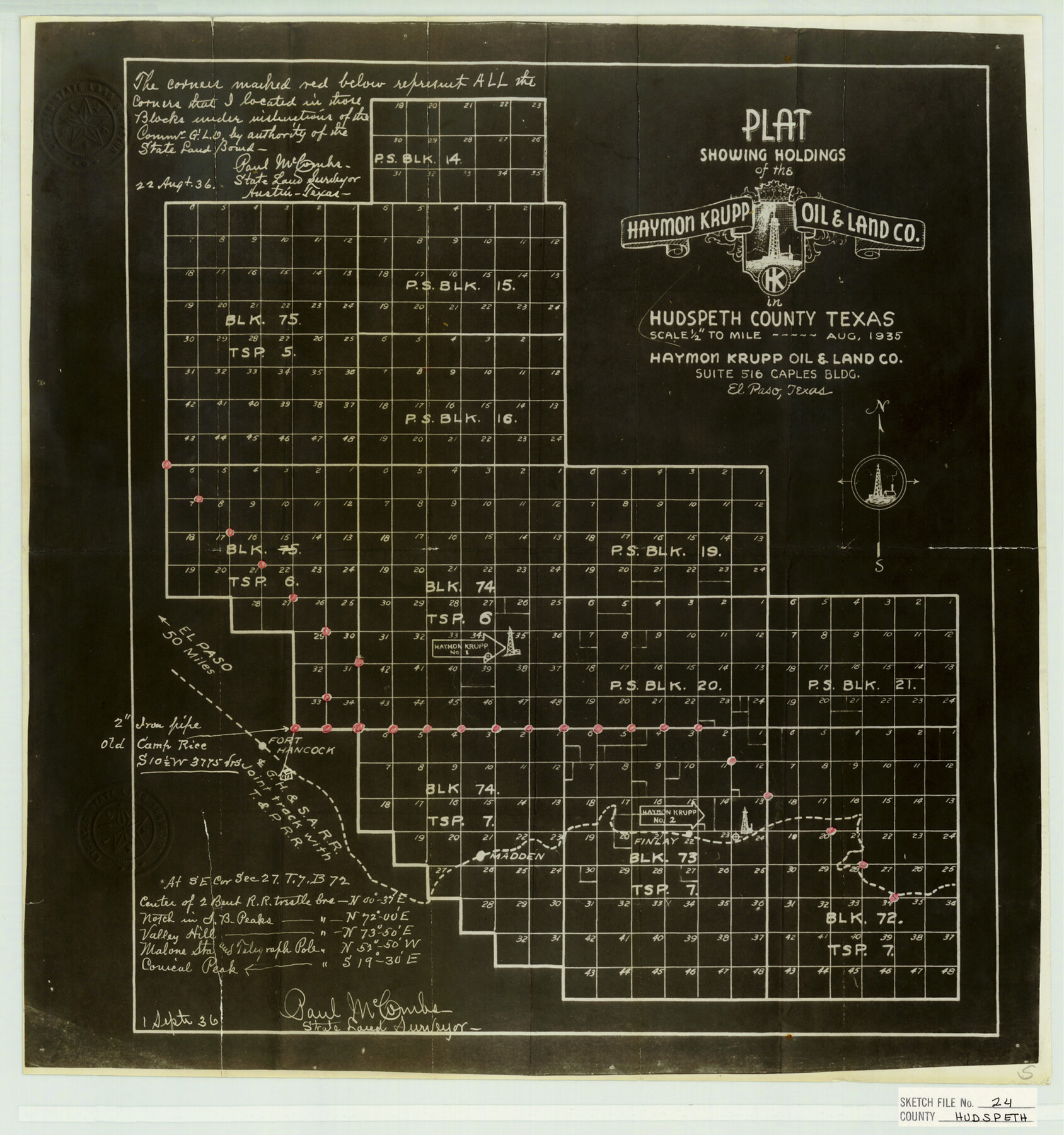
Hudspeth County Sketch File 24
Plat Showing Holdings of the Haymon Krup Oil & Land Co. in Hudspeth County, Texas
-
Map/Doc
11802
-
Collection
General Map Collection
-
Object Dates
9/28/1936 (Creation Date)
9/28/1936 (File Date)
9/22/1836 (Survey Date)
-
People and Organizations
Paul McCombs (Surveyor/Engineer)
-
Counties
Hudspeth
-
Subjects
Surveying Sketch File
-
Height x Width
17.8 x 16.7 inches
45.2 x 42.4 cm
-
Medium
photostat, negative
-
Scale
.5:1 mile
-
Features
Fort Hancock
Old Camp Rice
Finlay
Madden
Road to El Paso
Part of: General Map Collection
Red River County Working Sketch 38

Print $20.00
- Digital $50.00
Red River County Working Sketch 38
1965
Size 24.0 x 24.9 inches
Map/Doc 72021
Harris County Sketch File 11a

Print $6.00
- Digital $50.00
Harris County Sketch File 11a
Size 11.0 x 10.0 inches
Map/Doc 25351
Angelina County Working Sketch 23

Print $20.00
- Digital $50.00
Angelina County Working Sketch 23
1953
Size 19.8 x 32.6 inches
Map/Doc 67105
Flight Mission No. CLL-1N, Frame 37, Willacy County

Print $20.00
- Digital $50.00
Flight Mission No. CLL-1N, Frame 37, Willacy County
1954
Size 18.4 x 22.0 inches
Map/Doc 87018
Presidio County Sketch File 78

Print $6.00
- Digital $50.00
Presidio County Sketch File 78
Size 8.4 x 14.3 inches
Map/Doc 34706
Gregg County Rolled Sketch 17

Print $20.00
- Digital $50.00
Gregg County Rolled Sketch 17
1933
Size 14.0 x 27.9 inches
Map/Doc 6040

Flight Mission No. DIX-10P, Frame 63, Aransas County

Print $20.00
- Digital $50.00
Flight Mission No. DIX-10P, Frame 63, Aransas County
1956
Size 18.7 x 22.3 inches
Map/Doc 83924
Starr County Working Sketch 22

Print $20.00
- Digital $50.00
Starr County Working Sketch 22
1983
Size 25.8 x 33.1 inches
Map/Doc 63938
Flight Mission No. DIX-6P, Frame 183, Aransas County

Print $20.00
- Digital $50.00
Flight Mission No. DIX-6P, Frame 183, Aransas County
1956
Size 19.1 x 22.7 inches
Map/Doc 83845
Lampasas County Boundary File 16a

Print $28.00
- Digital $50.00
Lampasas County Boundary File 16a
Size 13.9 x 8.4 inches
Map/Doc 56223

You may also like
Flight Mission No. CUG-3P, Frame 23, Kleberg County

Print $20.00
- Digital $50.00
Flight Mission No. CUG-3P, Frame 23, Kleberg County
1956
Size 18.5 x 22.3 inches
Map/Doc 86233
Nueces County Sketch File 46

Print $44.00
- Digital $50.00
Nueces County Sketch File 46
1907
Size 11.1 x 8.7 inches
Map/Doc 32643
Eastland County Working Sketch 61

Print $20.00
- Digital $50.00
Eastland County Working Sketch 61
1989
Size 35.4 x 41.0 inches
Map/Doc 68842
Rand McNally Standard Map of Texas

Rand McNally Standard Map of Texas
1930
Size 34.6 x 28.0 inches
Map/Doc 2147
Stremme General Land Office Drawings, front door

Print $20.00
Stremme General Land Office Drawings, front door
Size 27.4 x 21.9 inches
Map/Doc 79737
Map of Corpus Christi Bay in Nueces County Showing Subdivision for Mineral Development

Print $40.00
- Digital $50.00
Map of Corpus Christi Bay in Nueces County Showing Subdivision for Mineral Development
1950
Size 49.3 x 37.2 inches
Map/Doc 3129
Subdivision of Alexander Ranch, Cochran County, Texas

Print $20.00
- Digital $50.00
Subdivision of Alexander Ranch, Cochran County, Texas
Size 15.4 x 29.8 inches
Map/Doc 92496
Fannin County Working Sketch 4

Print $20.00
- Digital $50.00
Fannin County Working Sketch 4
1925
Size 24.6 x 31.4 inches
Map/Doc 69158
Flight Mission No. CRC-4R, Frame 109, Chambers County

Print $20.00
- Digital $50.00
Flight Mission No. CRC-4R, Frame 109, Chambers County
1956
Size 18.5 x 22.5 inches
Map/Doc 84906
Map of Survey 8, Block 1, D.B. Gardner

Print $20.00
- Digital $50.00
Map of Survey 8, Block 1, D.B. Gardner
1915
Size 13.0 x 18.8 inches
Map/Doc 10763
Flight Mission No. BRA-16M, Frame 167, Jefferson County

Print $20.00
- Digital $50.00
Flight Mission No. BRA-16M, Frame 167, Jefferson County
1953
Size 18.5 x 22.3 inches
Map/Doc 85765
Kendall County Working Sketch 16

Print $20.00
- Digital $50.00
Kendall County Working Sketch 16
1967
Size 28.0 x 29.1 inches
Map/Doc 66688