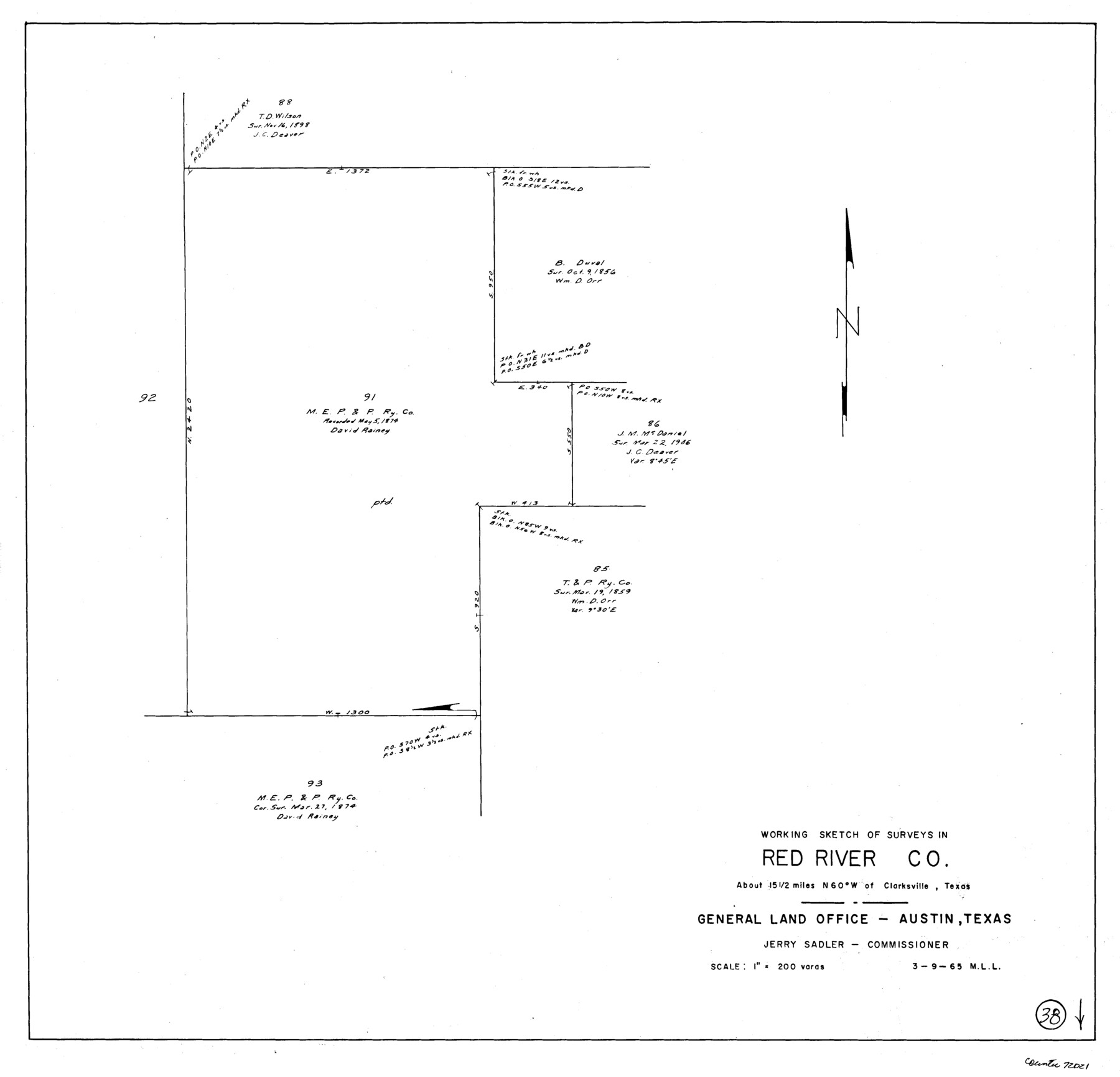
Red River County Working Sketch 38
-
Map/Doc
72021
-
Collection
General Map Collection
-
Object Dates
3/9/1965 (Creation Date)
-
People and Organizations
M. L. Liles (Draftsman)
-
Counties
Red River
-
Subjects
Surveying Working Sketch
-
Height x Width
24.0 x 24.9 inches
61.0 x 63.3 cm
-
Scale
1" = 200 varas
Part of: General Map Collection
Hall County Sketch File 24

Print $10.00
- Digital $50.00
Hall County Sketch File 24
1911
Size 11.2 x 8.6 inches
Map/Doc 24817
Flight Mission No. BQR-4K, Frame 64, Brazoria County

Print $20.00
- Digital $50.00
Flight Mission No. BQR-4K, Frame 64, Brazoria County
1952
Size 18.7 x 22.4 inches
Map/Doc 83997
Glasscock County Sketch File 16

Print $6.00
- Digital $50.00
Glasscock County Sketch File 16
1935
Size 14.4 x 10.9 inches
Map/Doc 24186
Kaufman County Sketch File 17 1/2

Print $6.00
- Digital $50.00
Kaufman County Sketch File 17 1/2
1888
Size 17.0 x 11.1 inches
Map/Doc 28659
Rockwall County Sketch File 6

Print $4.00
- Digital $50.00
Rockwall County Sketch File 6
1862
Size 8.5 x 9.4 inches
Map/Doc 35425
Flight Mission No. CUG-3P, Frame 21, Kleberg County

Print $20.00
- Digital $50.00
Flight Mission No. CUG-3P, Frame 21, Kleberg County
1956
Size 18.6 x 22.2 inches
Map/Doc 86231
Hale County Boundary File 9

Print $68.00
- Digital $50.00
Hale County Boundary File 9
Size 14.2 x 8.8 inches
Map/Doc 54111
Dawson County Sketch File 19

Print $20.00
- Digital $50.00
Dawson County Sketch File 19
1951
Size 18.5 x 24.7 inches
Map/Doc 11295
Medina County Working Sketch 9

Print $20.00
- Digital $50.00
Medina County Working Sketch 9
1959
Size 25.3 x 38.8 inches
Map/Doc 70924
Terrell County Working Sketch 19

Print $20.00
- Digital $50.00
Terrell County Working Sketch 19
1932
Size 18.6 x 25.6 inches
Map/Doc 69801
Jones County Working Sketch 7

Print $20.00
- Digital $50.00
Jones County Working Sketch 7
1957
Size 30.8 x 12.7 inches
Map/Doc 66645
[Map of Texas and Pacific Blocks from Brazos River westward through Palo Pinto, Stephens, Shackelford, Jones, Callahan, Taylor, Fisher, Nolan and Mitchell Counties]
![64510, [Map of Texas and Pacific Blocks from Brazos River westward through Palo Pinto, Stephens, Shackelford, Jones, Callahan, Taylor, Fisher, Nolan and Mitchell Counties], General Map Collection](https://historictexasmaps.com/wmedia_w700/maps/64510-1.tif.jpg)
Print $20.00
- Digital $50.00
[Map of Texas and Pacific Blocks from Brazos River westward through Palo Pinto, Stephens, Shackelford, Jones, Callahan, Taylor, Fisher, Nolan and Mitchell Counties]
Size 35.5 x 19.0 inches
Map/Doc 64510
You may also like
Subdivision for R.N. Graham

Print $3.00
- Digital $50.00
Subdivision for R.N. Graham
1913
Size 10.4 x 15.2 inches
Map/Doc 473
Maps of Gulf Intracoastal Waterway, Texas - Sabine River to the Rio Grande and connecting waterways including ship channels

Print $20.00
- Digital $50.00
Maps of Gulf Intracoastal Waterway, Texas - Sabine River to the Rio Grande and connecting waterways including ship channels
1966
Size 14.6 x 22.3 inches
Map/Doc 61956
[West Central Portion of County]
![91257, [West Central Portion of County], Twichell Survey Records](https://historictexasmaps.com/wmedia_w700/maps/91257-1.tif.jpg)
Print $20.00
- Digital $50.00
[West Central Portion of County]
Size 19.5 x 9.8 inches
Map/Doc 91257
Texas Aerial Photo-Illustrated Map

Texas Aerial Photo-Illustrated Map
Size 21.3 x 28.3 inches
Map/Doc 94397
Stonewall County Working Sketch 19

Print $20.00
- Digital $50.00
Stonewall County Working Sketch 19
1957
Size 35.3 x 35.1 inches
Map/Doc 62326
Reagan County Sketch File 32

Print $6.00
- Digital $50.00
Reagan County Sketch File 32
1954
Size 11.5 x 9.0 inches
Map/Doc 35025
Map of Adrian, the New Town in the Panhandle, Oldham County, Texas

Print $20.00
- Digital $50.00
Map of Adrian, the New Town in the Panhandle, Oldham County, Texas
Size 21.5 x 25.8 inches
Map/Doc 92135
Sketch Showing all that Portion of Block 24 North of Santa Fe R. R. Right-of-Way in Original Town of Lubbock

Print $20.00
- Digital $50.00
Sketch Showing all that Portion of Block 24 North of Santa Fe R. R. Right-of-Way in Original Town of Lubbock
1925
Size 27.5 x 35.6 inches
Map/Doc 92810
El Paso County Sketch File 17

Print $20.00
- Digital $50.00
El Paso County Sketch File 17
1885
Size 20.1 x 30.9 inches
Map/Doc 11453
Triangulation Net of the United States

Print $20.00
- Digital $50.00
Triangulation Net of the United States
1938
Size 28.1 x 42.2 inches
Map/Doc 3117
Real County Sketch File 18

Print $28.00
- Digital $50.00
Real County Sketch File 18
1964
Size 14.3 x 8.9 inches
Map/Doc 35076
Hutchinson County Rolled Sketch 40

Print $20.00
- Digital $50.00
Hutchinson County Rolled Sketch 40
1981
Size 26.2 x 37.4 inches
Map/Doc 6305