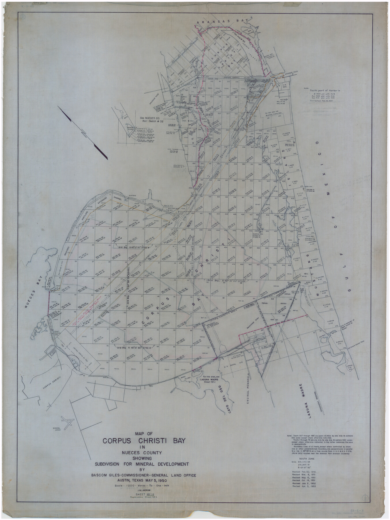
Map of Corpus Christi Bay in Nueces County Showing Subdivision for Mineral Development
K-3-42
-
Map/Doc
3129
-
Collection
General Map Collection
-
Object Dates
1950 (Creation Date)
-
People and Organizations
General Land Office (Publisher)
-
Counties
Nueces
-
Subjects
Energy Offshore Submerged Area
-
Height x Width
49.3 x 37.2 inches
125.2 x 94.5 cm
-
Comments
Sheet no. 1a, supercedes sheet no. 1
Part of: General Map Collection
Cass County Rolled Sketch 1

Print $20.00
- Digital $50.00
Cass County Rolled Sketch 1
1945
Size 22.1 x 23.7 inches
Map/Doc 5408
Uvalde County Working Sketch 56

Print $20.00
- Digital $50.00
Uvalde County Working Sketch 56
1985
Size 44.8 x 40.6 inches
Map/Doc 72126
Roberts County Boundary File 2c

Print $28.00
- Digital $50.00
Roberts County Boundary File 2c
Size 9.5 x 28.3 inches
Map/Doc 58363
Flight Mission No. BRA-7M, Frame 139, Jefferson County

Print $20.00
- Digital $50.00
Flight Mission No. BRA-7M, Frame 139, Jefferson County
1953
Size 18.7 x 22.4 inches
Map/Doc 85533

Sutton County

Print $40.00
- Digital $50.00
Sutton County
1898
Size 39.1 x 56.5 inches
Map/Doc 63051
San Jacinto County Sketch File 24

Print $18.00
San Jacinto County Sketch File 24
2001
Size 14.5 x 8.9 inches
Map/Doc 35816
Atascosa County Working Sketch 30

Print $20.00
- Digital $50.00
Atascosa County Working Sketch 30
1980
Size 16.4 x 20.6 inches
Map/Doc 67226
Sutton County Sketch File 41

Print $4.00
- Digital $50.00
Sutton County Sketch File 41
1940
Size 14.4 x 8.6 inches
Map/Doc 37507
Goliad County Sketch File 4

Print $6.00
- Digital $50.00
Goliad County Sketch File 4
1857
Size 7.7 x 12.3 inches
Map/Doc 24216

[Surveys in the Milam District along the Leon River]
![272, [Surveys in the Milam District along the Leon River], General Map Collection](https://historictexasmaps.com/wmedia_w700/maps/272.tif.jpg)
Print $20.00
- Digital $50.00
[Surveys in the Milam District along the Leon River]
1845
Size 12.0 x 15.4 inches
Map/Doc 272
You may also like
1988 Land Use - El Paso, Ciudad Juarez and Vicinity

Print $20.00
- Digital $50.00
1988 Land Use - El Paso, Ciudad Juarez and Vicinity
1988
Size 34.1 x 25.0 inches
Map/Doc 87370
Flight Mission No. DQO-8K, Frame 57, Galveston County

Print $20.00
- Digital $50.00
Flight Mission No. DQO-8K, Frame 57, Galveston County
1952
Size 18.9 x 22.6 inches
Map/Doc 85164
Uvalde County Sketch File 20

Print $40.00
- Digital $50.00
Uvalde County Sketch File 20
1882
Size 15.0 x 13.2 inches
Map/Doc 39002
[H. & T. C. Blocks 46 and A along Canadian River]
![91797, [H. & T. C. Blocks 46 and A along Canadian River], Twichell Survey Records](https://historictexasmaps.com/wmedia_w700/maps/91797-1.tif.jpg)
Print $3.00
- Digital $50.00
[H. & T. C. Blocks 46 and A along Canadian River]
Size 13.2 x 9.4 inches
Map/Doc 91797
Burnet County Working Sketch 16

Print $20.00
- Digital $50.00
Burnet County Working Sketch 16
1979
Size 22.8 x 32.5 inches
Map/Doc 67859

Jackson County Working Sketch 1

Print $20.00
- Digital $50.00
Jackson County Working Sketch 1
1911
Size 20.6 x 13.0 inches
Map/Doc 66449
Red River County Working Sketch 79

Print $40.00
- Digital $50.00
Red River County Working Sketch 79
1986
Size 43.8 x 61.1 inches
Map/Doc 72062
Flight Mission No. DAG-23K, Frame 150, Matagorda County

Print $20.00
- Digital $50.00
Flight Mission No. DAG-23K, Frame 150, Matagorda County
1953
Size 18.6 x 22.4 inches
Map/Doc 86498
Travis County Rolled Sketch 11

Print $20.00
- Digital $50.00
Travis County Rolled Sketch 11
Size 23.3 x 37.9 inches
Map/Doc 8014
Morris County Rolled Sketch 2A

Print $20.00
- Digital $50.00
Morris County Rolled Sketch 2A
Size 24.3 x 19.2 inches
Map/Doc 10255
Palo Pinto County Sketch File 25

Print $26.00
- Digital $50.00
Palo Pinto County Sketch File 25
1874
Size 10.1 x 8.9 inches
Map/Doc 33404