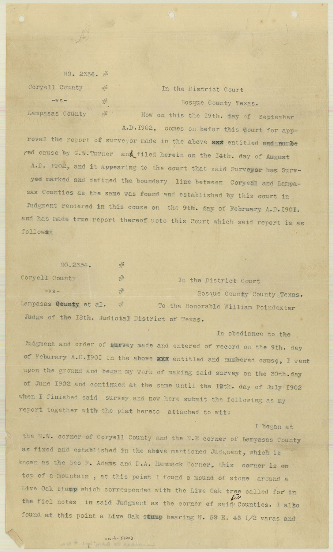
Lampasas County Boundary File 16a
Report of Surveyor G. W. Turner in cause No. 2354 Coryell County vs. Lampasas County
-
Map/Doc
56223
-
Collection
General Map Collection
-
Counties
Lampasas
-
Subjects
County Boundaries
-
Height x Width
13.9 x 8.4 inches
35.3 x 21.3 cm
Part of: General Map Collection
[McMullen and Live Oak County]
![10789, [McMullen and Live Oak County], General Map Collection](https://historictexasmaps.com/wmedia_w700/maps/10789.tif.jpg)
Print $20.00
- Digital $50.00
[McMullen and Live Oak County]
1870
Size 34.3 x 36.0 inches
Map/Doc 10789
Flight Mission No. BRA-7M, Frame 197, Jefferson County

Print $20.00
- Digital $50.00
Flight Mission No. BRA-7M, Frame 197, Jefferson County
1953
Size 18.6 x 22.4 inches
Map/Doc 85565
[Neches River Bed, Plat and Calculations]
![77100, [Neches River Bed, Plat and Calculations], General Map Collection](https://historictexasmaps.com/wmedia_w700/maps/77100.tif.jpg)
Print $20.00
- Digital $50.00
[Neches River Bed, Plat and Calculations]
1928
Size 25.6 x 37.2 inches
Map/Doc 77100
Harris County Historic Topographic 3

Print $20.00
- Digital $50.00
Harris County Historic Topographic 3
1916
Size 29.4 x 22.5 inches
Map/Doc 65813
Brewster County Rolled Sketch 101

Print $40.00
- Digital $50.00
Brewster County Rolled Sketch 101
1927
Size 55.0 x 40.0 inches
Map/Doc 8509
Burnet County Boundary File 7a

Print $30.00
- Digital $50.00
Burnet County Boundary File 7a
Size 14.1 x 8.5 inches
Map/Doc 50902
Tom Green County Rolled Sketch 16

Print $20.00
- Digital $50.00
Tom Green County Rolled Sketch 16
1954
Size 38.2 x 44.6 inches
Map/Doc 10004
Red River County Working Sketch 18

Print $20.00
- Digital $50.00
Red River County Working Sketch 18
1955
Size 31.1 x 34.3 inches
Map/Doc 72001
Montgomery County Rolled Sketch 18

Print $40.00
- Digital $50.00
Montgomery County Rolled Sketch 18
Size 51.4 x 25.3 inches
Map/Doc 9528
Rains County Working Sketch 8

Print $20.00
- Digital $50.00
Rains County Working Sketch 8
1965
Size 24.3 x 28.1 inches
Map/Doc 71834
Brazos County Working Sketch 4

Print $20.00
- Digital $50.00
Brazos County Working Sketch 4
1976
Size 22.5 x 20.6 inches
Map/Doc 67479
Refugio County Working Sketch 16

Print $20.00
- Digital $50.00
Refugio County Working Sketch 16
1965
Size 34.0 x 31.8 inches
Map/Doc 63525
You may also like
San Augustine County

Print $20.00
- Digital $50.00
San Augustine County
1895
Size 23.7 x 17.2 inches
Map/Doc 4015
Rhoades Heights, North Part of West Half, Section 8, Block E

Print $20.00
- Digital $50.00
Rhoades Heights, North Part of West Half, Section 8, Block E
Size 29.2 x 13.5 inches
Map/Doc 92759
Township 4 South Ranges 12 and 13 West, South Western District, Louisiana

Print $20.00
- Digital $50.00
Township 4 South Ranges 12 and 13 West, South Western District, Louisiana
1879
Size 18.3 x 24.1 inches
Map/Doc 65890
Denton County Working Sketch 11

Print $20.00
- Digital $50.00
Denton County Working Sketch 11
1960
Size 26.2 x 20.4 inches
Map/Doc 68616
Zapata County Sketch File 5

Print $20.00
- Digital $50.00
Zapata County Sketch File 5
1886
Size 15.4 x 16.9 inches
Map/Doc 12719
Atascosa County Sketch File 26

Print $4.00
- Digital $50.00
Atascosa County Sketch File 26
Size 8.2 x 12.7 inches
Map/Doc 13794
The Mexican Department of Bexar. On the Eve of Texas Independence, 1836

Print $20.00
The Mexican Department of Bexar. On the Eve of Texas Independence, 1836
2020
Size 16.0 x 21.7 inches
Map/Doc 95971
Aransas Pass to Baffin Bay

Print $20.00
- Digital $50.00
Aransas Pass to Baffin Bay
1992
Size 45.0 x 36.0 inches
Map/Doc 73423
[Garza, Blanco, Uvalde and Crosby County School Land]
![90250, [Garza, Blanco, Uvalde and Crosby County School Land], Twichell Survey Records](https://historictexasmaps.com/wmedia_w700/maps/90250-1.tif.jpg)
Print $3.00
- Digital $50.00
[Garza, Blanco, Uvalde and Crosby County School Land]
1913
Size 14.6 x 11.8 inches
Map/Doc 90250
Potter County Sketch File 10

Print $40.00
- Digital $50.00
Potter County Sketch File 10
Size 58.9 x 37.7 inches
Map/Doc 10576
[Sketch for Mineral Application 33721 - 33725 Incl. - Padre and Mustang Island]
![2874, [Sketch for Mineral Application 33721 - 33725 Incl. - Padre and Mustang Island], General Map Collection](https://historictexasmaps.com/wmedia_w700/maps/2874.tif.jpg)
Print $20.00
- Digital $50.00
[Sketch for Mineral Application 33721 - 33725 Incl. - Padre and Mustang Island]
1941
Size 40.2 x 22.8 inches
Map/Doc 2874
Reagan County Sketch File 29

Print $20.00
- Digital $50.00
Reagan County Sketch File 29
1951
Size 21.3 x 30.5 inches
Map/Doc 12225