Hidalgo County Sketch File 10
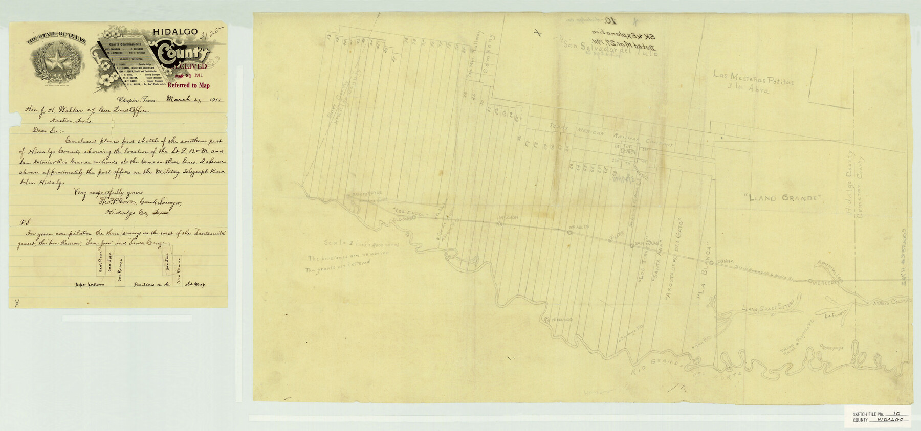
[Sketch of the southern part of the county showing porciones along the Rio Grande and the locations of the railroads and towns on those lines]
-
Map/Doc
11762
-
Collection
General Map Collection
-
Object Dates
3/27/1911 (Creation Date)
3/31/1911 (File Date)
-
People and Organizations
Thomas P. Gore (Surveyor/Engineer)
-
Counties
Hidalgo Starr Cameron
-
Subjects
Surveying Sketch File
-
Height x Width
16.3 x 34.8 inches
41.4 x 88.4 cm
-
Medium
paper, manuscript
-
Scale
1" = 4000 varas
-
Features
Havana Ranch
Run Post Office
Rio Grande del Norte
Toluca Ranch
Relampago
Progreso Post Office
Anacijittas Lake
Mercedes
Arroyo Colorado
La Fuesta
Llano Grade Estero
Savage Post Office
Hidalgo
SLB&M
Sam Fordyce
Closner
Ojo de Agua
Chihuahua
Abram Post Office
Mission
McAllen
Pharr
San Juan
Donna
Military Telegraph Road
SA&RG
Part of: General Map Collection

Bee County Working Sketch 14

Print $20.00
- Digital $50.00
Bee County Working Sketch 14
1948
Size 22.2 x 17.7 inches
Map/Doc 67264
Fort Bend County Working Sketch 1

Print $20.00
- Digital $50.00
Fort Bend County Working Sketch 1
Size 16.0 x 27.4 inches
Map/Doc 69207
Kerr County Sketch File 25

Print $4.00
- Digital $50.00
Kerr County Sketch File 25
1873
Size 10.0 x 8.0 inches
Map/Doc 28905
Jackson County Boundary File 4

Print $4.00
- Digital $50.00
Jackson County Boundary File 4
Size 10.2 x 7.9 inches
Map/Doc 55460
Ellis County Sketch File 21

Print $24.00
- Digital $50.00
Ellis County Sketch File 21
1879
Size 7.6 x 12.4 inches
Map/Doc 21878
Map of Shelby County

Print $20.00
- Digital $50.00
Map of Shelby County
1863
Size 18.6 x 22.3 inches
Map/Doc 4031
Shelby County Working Sketch 2

Print $20.00
- Digital $50.00
Shelby County Working Sketch 2
Size 32.9 x 37.3 inches
Map/Doc 63855
Cottle County Working Sketch 6

Print $20.00
- Digital $50.00
Cottle County Working Sketch 6
1927
Size 23.0 x 29.3 inches
Map/Doc 68316
Navarro County Sketch File 14

Print $4.00
- Digital $50.00
Navarro County Sketch File 14
1873
Size 8.4 x 10.2 inches
Map/Doc 32326
San Augustine County Working Sketch 11a

Print $20.00
- Digital $50.00
San Augustine County Working Sketch 11a
Size 18.8 x 24.4 inches
Map/Doc 63698
Hockley County Sketch File 19

Print $20.00
- Digital $50.00
Hockley County Sketch File 19
1944
Size 14.9 x 25.8 inches
Map/Doc 11775
You may also like
Motley County Sketch File DD (S)

Print $22.00
- Digital $50.00
Motley County Sketch File DD (S)
Size 10.9 x 7.1 inches
Map/Doc 32159
[John Gibbs and surrounding surveys]
![91161, [John Gibbs and surrounding surveys], Twichell Survey Records](https://historictexasmaps.com/wmedia_w700/maps/91161-1.tif.jpg)
Print $20.00
- Digital $50.00
[John Gibbs and surrounding surveys]
Size 18.8 x 22.8 inches
Map/Doc 91161
Map of Grimes Co.

Print $20.00
- Digital $50.00
Map of Grimes Co.
1881
Size 32.6 x 17.5 inches
Map/Doc 66843
Lavaca County Working Sketch 11

Print $20.00
- Digital $50.00
Lavaca County Working Sketch 11
1954
Size 34.0 x 28.3 inches
Map/Doc 70364
Kleberg County Rolled Sketch 10-34

Print $20.00
- Digital $50.00
Kleberg County Rolled Sketch 10-34
1952
Size 38.2 x 32.3 inches
Map/Doc 9384
[H. & G. N. Block 1]
![90943, [H. & G. N. Block 1], Twichell Survey Records](https://historictexasmaps.com/wmedia_w700/maps/90943-1.tif.jpg)
Print $20.00
- Digital $50.00
[H. & G. N. Block 1]
1873
Size 14.3 x 17.6 inches
Map/Doc 90943
Louisiana and Texas Intracoastal Waterway

Print $20.00
- Digital $50.00
Louisiana and Texas Intracoastal Waterway
1929
Size 13.9 x 19.3 inches
Map/Doc 83343
Crockett County Rolled Sketch 59

Print $20.00
- Digital $50.00
Crockett County Rolled Sketch 59
1946
Size 30.1 x 20.9 inches
Map/Doc 5602
General Highway Map. Detail of Cities and Towns in Milam County, Texas [Rockdale and Cameron and vicinities]
![79598, General Highway Map. Detail of Cities and Towns in Milam County, Texas [Rockdale and Cameron and vicinities], Texas State Library and Archives](https://historictexasmaps.com/wmedia_w700/maps/79598.tif.jpg)
Print $20.00
General Highway Map. Detail of Cities and Towns in Milam County, Texas [Rockdale and Cameron and vicinities]
1961
Size 18.1 x 24.6 inches
Map/Doc 79598
Rusk County Sketch File 13

Print $4.00
Rusk County Sketch File 13
Size 8.6 x 6.4 inches
Map/Doc 35514
Live Oak County Sketch File 2

Print $4.00
- Digital $50.00
Live Oak County Sketch File 2
1856
Size 11.4 x 7.6 inches
Map/Doc 30253
Potter County

Print $20.00
- Digital $50.00
Potter County
1960
Size 42.6 x 34.6 inches
Map/Doc 66985