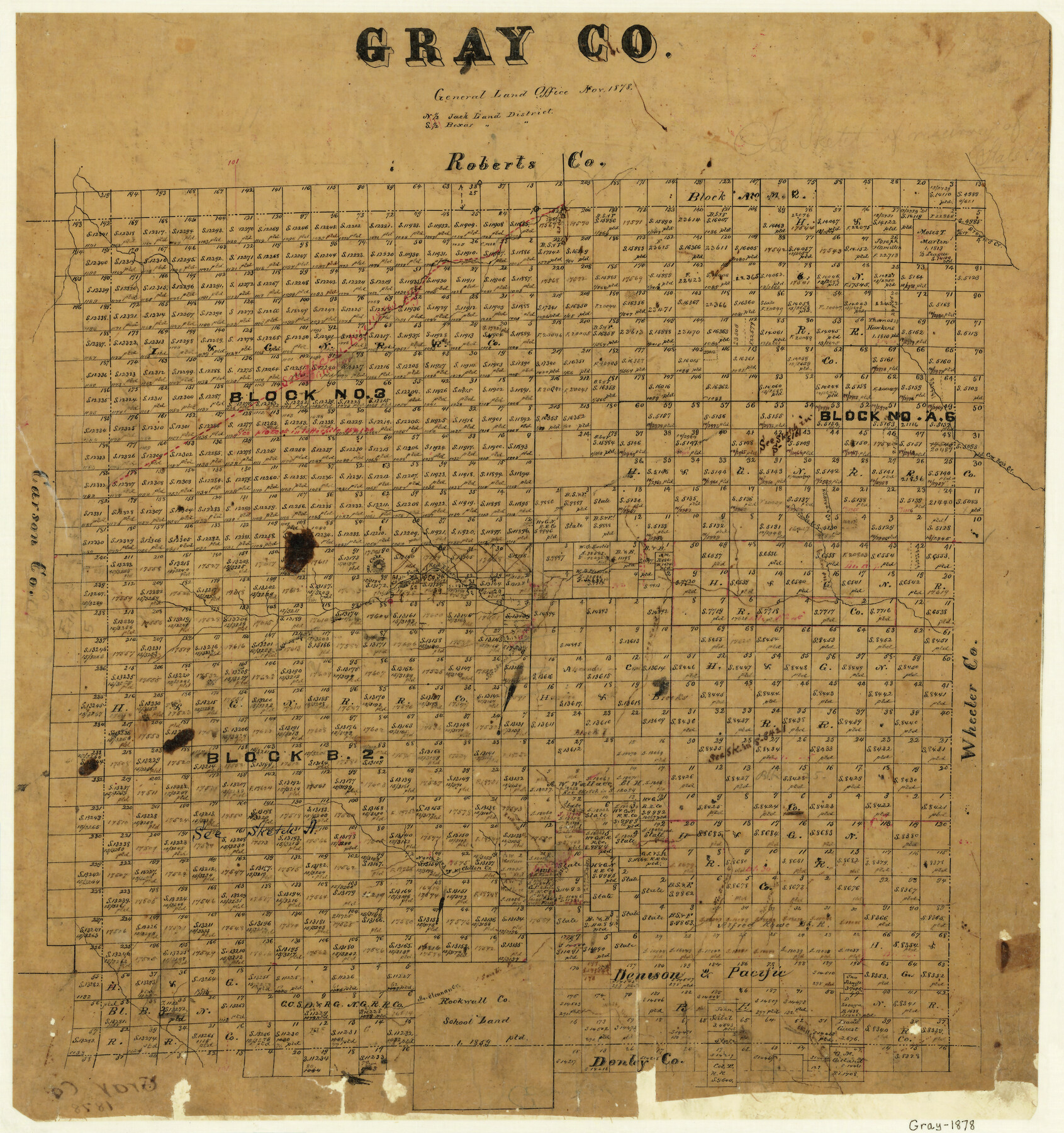
Gray County
-
Map/Doc
3596
-
Collection
General Map Collection
-
Object Dates
11/1878 (Creation Date)
-
Counties
Gray
-
Subjects
County
-
Height x Width
19.4 x 18.0 inches
49.3 x 45.7 cm
-
Comments
Note on map: "North part, Jack Land District; South part, Bexar Land District".
-
Features
Rockwall Creek
Skillet Creek
South Fork of McClellen Creek
McClellen Creek
White Fish Creek
Nic Baron Creek [sic]
North Fork of McClellen Creek
Peterson's Creek
Long Sandy Creek
SKR
Mount Coke
James Creek
Mildred's Creek
Cow Boy's [sic] Creek
Brown's Creek
Glascow [sic]
North Fork of Red River
Part of: General Map Collection
Sketch of a portion of the Texas Coast showing the relative positions of different harbours with the interior Military Posts, and the roads communicating with them, also two new routes from Black Point and Lamar to San Antonio

Print $20.00
- Digital $50.00
Sketch of a portion of the Texas Coast showing the relative positions of different harbours with the interior Military Posts, and the roads communicating with them, also two new routes from Black Point and Lamar to San Antonio
1855
Size 27.3 x 18.3 inches
Map/Doc 72709
Presidio County Rolled Sketch 120

Print $49.00
- Digital $50.00
Presidio County Rolled Sketch 120
Size 9.9 x 15.0 inches
Map/Doc 48816
Ochiltree County Boundary File 1c

Print $2.00
- Digital $50.00
Ochiltree County Boundary File 1c
Size 10.6 x 8.1 inches
Map/Doc 57674
Flight Mission No. DIX-10P, Frame 144, Aransas County

Print $20.00
- Digital $50.00
Flight Mission No. DIX-10P, Frame 144, Aransas County
1956
Size 18.6 x 22.3 inches
Map/Doc 83946
Flight Mission No. DCL-7C, Frame 78, Kenedy County

Print $20.00
- Digital $50.00
Flight Mission No. DCL-7C, Frame 78, Kenedy County
1943
Size 15.3 x 15.2 inches
Map/Doc 86064
Montgomery County Rolled Sketch 24

Print $20.00
- Digital $50.00
Montgomery County Rolled Sketch 24
Size 30.0 x 31.9 inches
Map/Doc 9534
Flight Mission No. DQN-7K, Frame 40, Calhoun County

Print $20.00
- Digital $50.00
Flight Mission No. DQN-7K, Frame 40, Calhoun County
1953
Size 18.5 x 22.2 inches
Map/Doc 84478
Nueces County Rolled Sketch 110A

Print $20.00
- Digital $50.00
Nueces County Rolled Sketch 110A
1990
Size 24.3 x 37.5 inches
Map/Doc 7118
Mitchell County Boundary File 2

Print $4.00
- Digital $50.00
Mitchell County Boundary File 2
Size 8.9 x 7.3 inches
Map/Doc 57367
Burnet County Sketch File 19

Print $4.00
- Digital $50.00
Burnet County Sketch File 19
1859
Size 11.6 x 8.2 inches
Map/Doc 16710
Orange County Working Sketch 39

Print $20.00
- Digital $50.00
Orange County Working Sketch 39
1966
Size 20.5 x 27.8 inches
Map/Doc 71371
Outer Continental Shelf Leasing Maps (Louisiana Offshore Operations)

Print $20.00
- Digital $50.00
Outer Continental Shelf Leasing Maps (Louisiana Offshore Operations)
1971
Size 20.2 x 15.0 inches
Map/Doc 76092
You may also like
Houston Ship Channel, Alexander Island to Carpenter Bayou

Print $40.00
- Digital $50.00
Houston Ship Channel, Alexander Island to Carpenter Bayou
1982
Size 36.0 x 49.5 inches
Map/Doc 69913
Red River County Sketch File 14

Print $8.00
- Digital $50.00
Red River County Sketch File 14
Size 13.7 x 9.0 inches
Map/Doc 35133
Fisher County Working Sketch 18

Print $20.00
- Digital $50.00
Fisher County Working Sketch 18
1941
Size 24.7 x 16.6 inches
Map/Doc 69152
Galveston County NRC Article 33.136 Sketch 30

Print $20.00
- Digital $50.00
Galveston County NRC Article 33.136 Sketch 30
2005
Size 12.1 x 15.5 inches
Map/Doc 82997
[Surveys in Milam's Colony between the Colorado River and northwest of the San Antonio Road]
![29, [Surveys in Milam's Colony between the Colorado River and northwest of the San Antonio Road], General Map Collection](https://historictexasmaps.com/wmedia_w700/maps/29-1.tif.jpg)
Print $20.00
- Digital $50.00
[Surveys in Milam's Colony between the Colorado River and northwest of the San Antonio Road]
Size 22.0 x 27.4 inches
Map/Doc 29
Flight Mission No. DQN-5K, Frame 48, Calhoun County

Print $20.00
- Digital $50.00
Flight Mission No. DQN-5K, Frame 48, Calhoun County
1953
Size 18.7 x 22.2 inches
Map/Doc 84393
Chambers County Rolled Sketch CL

Print $40.00
- Digital $50.00
Chambers County Rolled Sketch CL
1909
Size 56.2 x 21.0 inches
Map/Doc 8610
Reagan County Sketch File 16

Print $8.00
- Digital $50.00
Reagan County Sketch File 16
1932
Size 11.1 x 7.7 inches
Map/Doc 35002
Map of Upton County

Print $20.00
- Digital $50.00
Map of Upton County
1889
Size 23.4 x 21.4 inches
Map/Doc 4104
Coleman County Working Sketch 15

Print $20.00
- Digital $50.00
Coleman County Working Sketch 15
1952
Size 24.3 x 18.1 inches
Map/Doc 68081
Wood County Working Sketch 19

Print $20.00
- Digital $50.00
Wood County Working Sketch 19
1982
Size 25.8 x 24.8 inches
Map/Doc 62019
Flight Mission No. CUG-3P, Frame 77, Kleberg County

Print $20.00
- Digital $50.00
Flight Mission No. CUG-3P, Frame 77, Kleberg County
1956
Size 18.7 x 22.4 inches
Map/Doc 86252