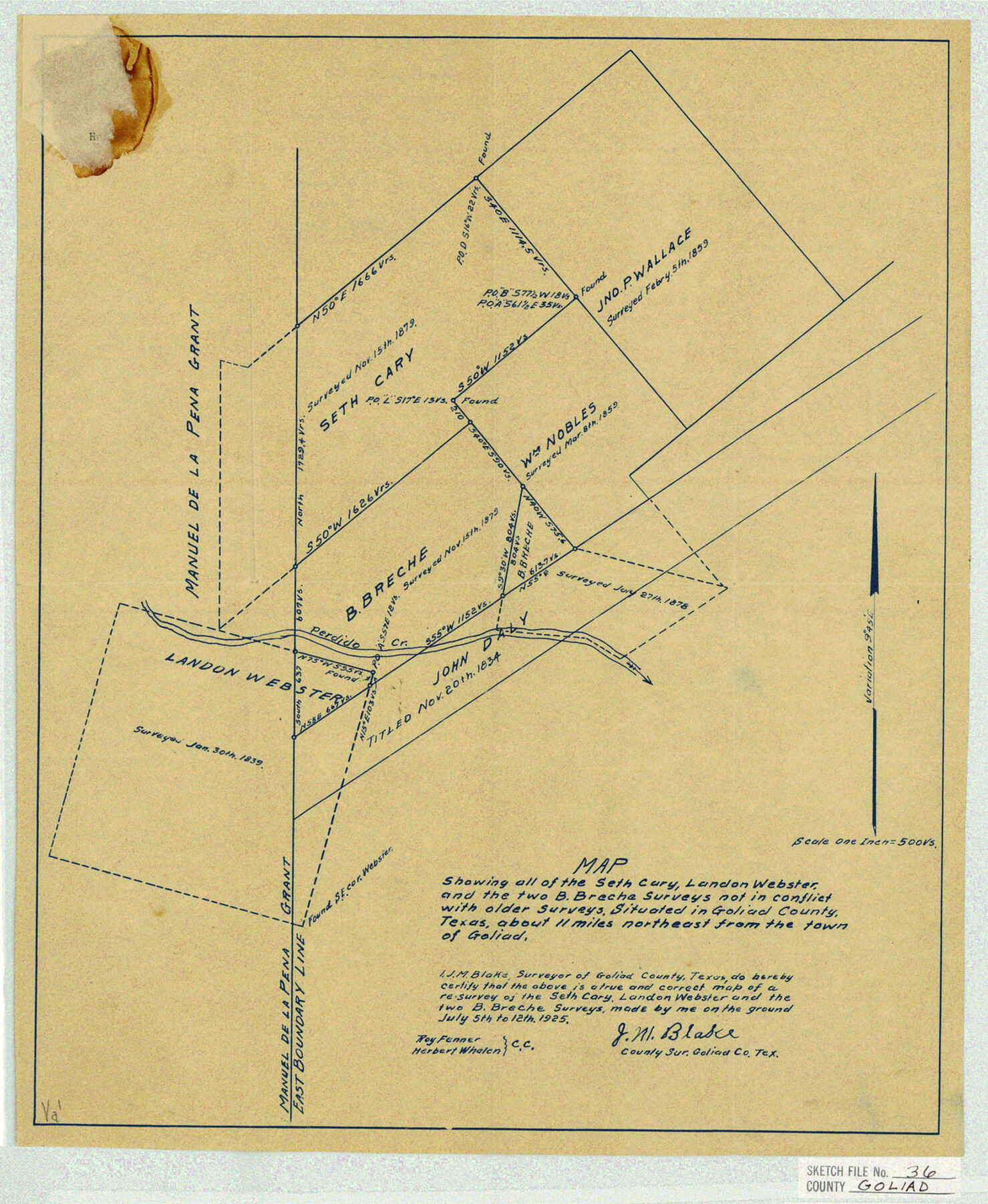
Goliad County Sketch File 36
Map showing all of the Seth Cury, Landon Webster, and the two B. Breche Surveys not in conflict with older surveys
-
Map/Doc
11571
-
Collection
General Map Collection
-
Object Dates
1925/7/13 (Creation Date)
1925/8/5 (File Date)
-
People and Organizations
J.M. Blake (Surveyor/Engineer)
Roy Fenner (Chainman)
Herbert Whalen (Chainman)
-
Counties
Goliad
-
Subjects
Surveying Sketch File
-
Height x Width
17.1 x 14.1 inches
43.4 x 35.8 cm
-
Medium
blueprint/diazo
-
Features
Peridio Creek
Part of: General Map Collection
Rusk County Working Sketch 5

Print $20.00
- Digital $50.00
Rusk County Working Sketch 5
1983
Size 33.1 x 25.7 inches
Map/Doc 63640
Live Oak County Working Sketch 6

Print $20.00
- Digital $50.00
Live Oak County Working Sketch 6
1930
Size 17.6 x 21.6 inches
Map/Doc 70591
Flight Mission No. CLL-1N, Frame 17, Willacy County

Print $20.00
- Digital $50.00
Flight Mission No. CLL-1N, Frame 17, Willacy County
1954
Size 18.5 x 22.1 inches
Map/Doc 87004
Grayson County Working Sketch 19

Print $20.00
- Digital $50.00
Grayson County Working Sketch 19
1956
Size 40.0 x 29.0 inches
Map/Doc 63258
Val Verde County Sketch File 51a

Print $8.00
- Digital $50.00
Val Verde County Sketch File 51a
1959
Size 11.4 x 8.8 inches
Map/Doc 39325
Flight Mission No. CGI-3N, Frame 43, Cameron County

Print $20.00
- Digital $50.00
Flight Mission No. CGI-3N, Frame 43, Cameron County
1954
Size 18.5 x 22.1 inches
Map/Doc 84549
Kimble County Rolled Sketch 42

Print $20.00
- Digital $50.00
Kimble County Rolled Sketch 42
1995
Size 37.7 x 47.8 inches
Map/Doc 9341
Webb County Working Sketch 97

Print $20.00
- Digital $50.00
Webb County Working Sketch 97
1994
Size 27.1 x 30.6 inches
Map/Doc 72464
Henderson County Rolled Sketch 5

Print $40.00
- Digital $50.00
Henderson County Rolled Sketch 5
1962
Size 62.7 x 43.9 inches
Map/Doc 49660
Madison County Working Sketch 2

Print $20.00
- Digital $50.00
Madison County Working Sketch 2
1933
Size 23.4 x 25.5 inches
Map/Doc 70764
Map of the L.I.T. Ranche situated in the Panhandle of Texas the property of the Prairie Cattle Co. L'd

Print $20.00
- Digital $50.00
Map of the L.I.T. Ranche situated in the Panhandle of Texas the property of the Prairie Cattle Co. L'd
1989
Size 21.0 x 12.6 inches
Map/Doc 2483
Edwards County Sketch File 22

Print $8.00
- Digital $50.00
Edwards County Sketch File 22
1890
Size 14.4 x 8.9 inches
Map/Doc 21743
You may also like
Schleicher County Rolled Sketch 24

Print $20.00
- Digital $50.00
Schleicher County Rolled Sketch 24
Size 29.1 x 15.9 inches
Map/Doc 7763
Amistad International Reservoir on Rio Grande 84

Print $20.00
- Digital $50.00
Amistad International Reservoir on Rio Grande 84
1949
Size 28.4 x 40.2 inches
Map/Doc 75513
Newton County Sketch File 18

Print $24.00
- Digital $50.00
Newton County Sketch File 18
1886
Size 12.1 x 8.3 inches
Map/Doc 32393
Jefferson County NRC Article 33.136 Sketch 7

Print $24.00
- Digital $50.00
Jefferson County NRC Article 33.136 Sketch 7
2009
Size 30.8 x 43.0 inches
Map/Doc 94711
[Beaumont, Sour Lake and Western Ry. Right of Way and Alignment - Frisco]
![64131, [Beaumont, Sour Lake and Western Ry. Right of Way and Alignment - Frisco], General Map Collection](https://historictexasmaps.com/wmedia_w700/maps/64131.tif.jpg)
Print $20.00
- Digital $50.00
[Beaumont, Sour Lake and Western Ry. Right of Way and Alignment - Frisco]
1910
Size 20.3 x 46.2 inches
Map/Doc 64131
Grayson County Sketch File 11

Print $4.00
- Digital $50.00
Grayson County Sketch File 11
1857
Size 13.0 x 8.0 inches
Map/Doc 24476
Jefferson County Working Sketch 12

Print $20.00
- Digital $50.00
Jefferson County Working Sketch 12
1947
Size 29.9 x 39.4 inches
Map/Doc 66555
Flight Mission No. CGI-4N, Frame 189, Cameron County

Print $20.00
- Digital $50.00
Flight Mission No. CGI-4N, Frame 189, Cameron County
1955
Size 18.5 x 22.2 inches
Map/Doc 84692
Milam County Rolled Sketch 5A

Print $20.00
- Digital $50.00
Milam County Rolled Sketch 5A
1997
Size 28.0 x 39.8 inches
Map/Doc 6778
Fort Bend County Working Sketch 26

Print $20.00
- Digital $50.00
Fort Bend County Working Sketch 26
1982
Size 18.5 x 23.6 inches
Map/Doc 69232
Hunt County Sketch File 35

Print $4.00
- Digital $50.00
Hunt County Sketch File 35
Size 5.3 x 8.3 inches
Map/Doc 27148
Bowie County Sketch File 6

Print $10.00
- Digital $50.00
Bowie County Sketch File 6
1927
Size 8.5 x 4.0 inches
Map/Doc 14839