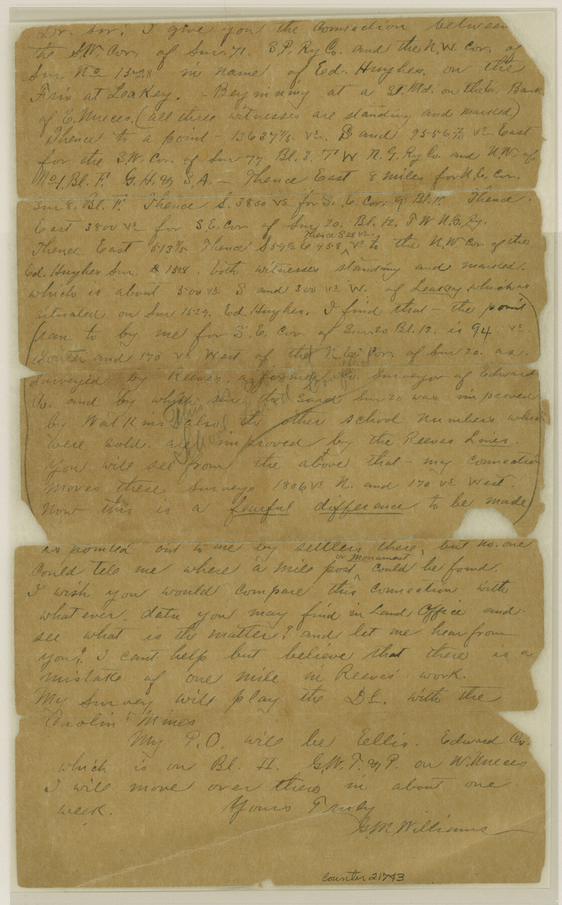
Edwards County Sketch File 22
[Connecting line between southwest corner of survey 71, S. P. RR. Co. and northwest corner of survey 1528]
-
Map/Doc
21743
-
Collection
General Map Collection
-
Object Dates
1890/4/11 (Creation Date)
1890/8/11 (File Date)
1889/8/1 (Survey Date)
-
People and Organizations
George M. Williams (Surveyor/Engineer)
-
Counties
Edwards Real
-
Subjects
Surveying Sketch File
-
Height x Width
14.4 x 8.9 inches
36.6 x 22.6 cm
-
Medium
paper, manuscript
-
Features
Frio River
Leakey
Nueces River
Part of: General Map Collection
St. Louis, Brownsville & Mexico Railway Location Map from Mile 100 to Mile 120

Print $40.00
- Digital $50.00
St. Louis, Brownsville & Mexico Railway Location Map from Mile 100 to Mile 120
1905
Size 20.0 x 61.2 inches
Map/Doc 64167
Travis County Boundary File 20

Print $6.00
- Digital $50.00
Travis County Boundary File 20
Size 14.4 x 9.2 inches
Map/Doc 59454
Sutton County Sketch File 53

Print $6.00
- Digital $50.00
Sutton County Sketch File 53
1948
Size 11.5 x 10.2 inches
Map/Doc 37532
Comanche County Sketch File 5

Print $4.00
- Digital $50.00
Comanche County Sketch File 5
1848
Size 8.6 x 8.3 inches
Map/Doc 19059
Eastland County Sketch File 9

Print $4.00
- Digital $50.00
Eastland County Sketch File 9
Size 10.5 x 8.2 inches
Map/Doc 21580
United States - Gulf Coast - Padre I. and Laguna Madre Lat. 27° 12' to Lat. 26° 33' Texas

Print $20.00
- Digital $50.00
United States - Gulf Coast - Padre I. and Laguna Madre Lat. 27° 12' to Lat. 26° 33' Texas
1913
Size 27.0 x 18.3 inches
Map/Doc 72819
Real County Working Sketch 20

Print $20.00
- Digital $50.00
Real County Working Sketch 20
1944
Size 19.0 x 24.9 inches
Map/Doc 71912
Marion County

Print $20.00
- Digital $50.00
Marion County
1943
Size 24.3 x 41.2 inches
Map/Doc 77365
Flight Mission No. BRA-7M, Frame 139, Jefferson County

Print $20.00
- Digital $50.00
Flight Mission No. BRA-7M, Frame 139, Jefferson County
1953
Size 18.7 x 22.4 inches
Map/Doc 85533
Wilbarger County Sketch File 23

Print $4.00
- Digital $50.00
Wilbarger County Sketch File 23
1887
Size 14.2 x 8.8 inches
Map/Doc 40223
Trinity River, Trinidad Sheet

Print $20.00
- Digital $50.00
Trinity River, Trinidad Sheet
1928
Size 39.0 x 46.3 inches
Map/Doc 65183
Travis County Sketch File 66

Print $12.00
- Digital $50.00
Travis County Sketch File 66
1950
Size 14.2 x 9.0 inches
Map/Doc 38440
You may also like
McCulloch County Working Sketch 4

Print $20.00
- Digital $50.00
McCulloch County Working Sketch 4
1956
Size 25.3 x 22.8 inches
Map/Doc 70679
Anderson County Working Sketch 25

Print $20.00
- Digital $50.00
Anderson County Working Sketch 25
1958
Size 33.1 x 36.6 inches
Map/Doc 67025
[Sketch between Collingsworth County and Oklahoma]
![89673, [Sketch between Collingsworth County and Oklahoma], Twichell Survey Records](https://historictexasmaps.com/wmedia_w700/maps/89673-1.tif.jpg)
Print $40.00
- Digital $50.00
[Sketch between Collingsworth County and Oklahoma]
Size 63.2 x 9.1 inches
Map/Doc 89673
[Aransas and Corpus Christi Bays]
![140, [Aransas and Corpus Christi Bays], General Map Collection](https://historictexasmaps.com/wmedia_w700/maps/140.tif.jpg)
Print $3.00
- Digital $50.00
[Aransas and Corpus Christi Bays]
1839
Size 11.4 x 16.5 inches
Map/Doc 140
Harris County NRC Article 33.136 Sketch 11

Print $28.00
- Digital $50.00
Harris County NRC Article 33.136 Sketch 11
2007
Size 24.0 x 36.0 inches
Map/Doc 94658
Wichita County Sketch File 11

Print $10.00
- Digital $50.00
Wichita County Sketch File 11
1880
Size 8.3 x 7.7 inches
Map/Doc 40056

Flight Mission No. DQO-2K, Frame 160, Galveston County

Print $20.00
- Digital $50.00
Flight Mission No. DQO-2K, Frame 160, Galveston County
1952
Size 18.7 x 22.4 inches
Map/Doc 85049
Travis County Working Sketch 54

Print $20.00
- Digital $50.00
Travis County Working Sketch 54
1976
Size 30.1 x 32.0 inches
Map/Doc 69438
San Saba County Working Sketch Graphic Index

Print $20.00
- Digital $50.00
San Saba County Working Sketch Graphic Index
1918
Size 46.5 x 41.1 inches
Map/Doc 76693
San Jacinto County Working Sketch 36

Print $40.00
- Digital $50.00
San Jacinto County Working Sketch 36
1964
Size 33.0 x 57.2 inches
Map/Doc 63749
Montgomery County Rolled Sketch 30

Print $40.00
- Digital $50.00
Montgomery County Rolled Sketch 30
1949
Size 34.6 x 51.3 inches
Map/Doc 9538