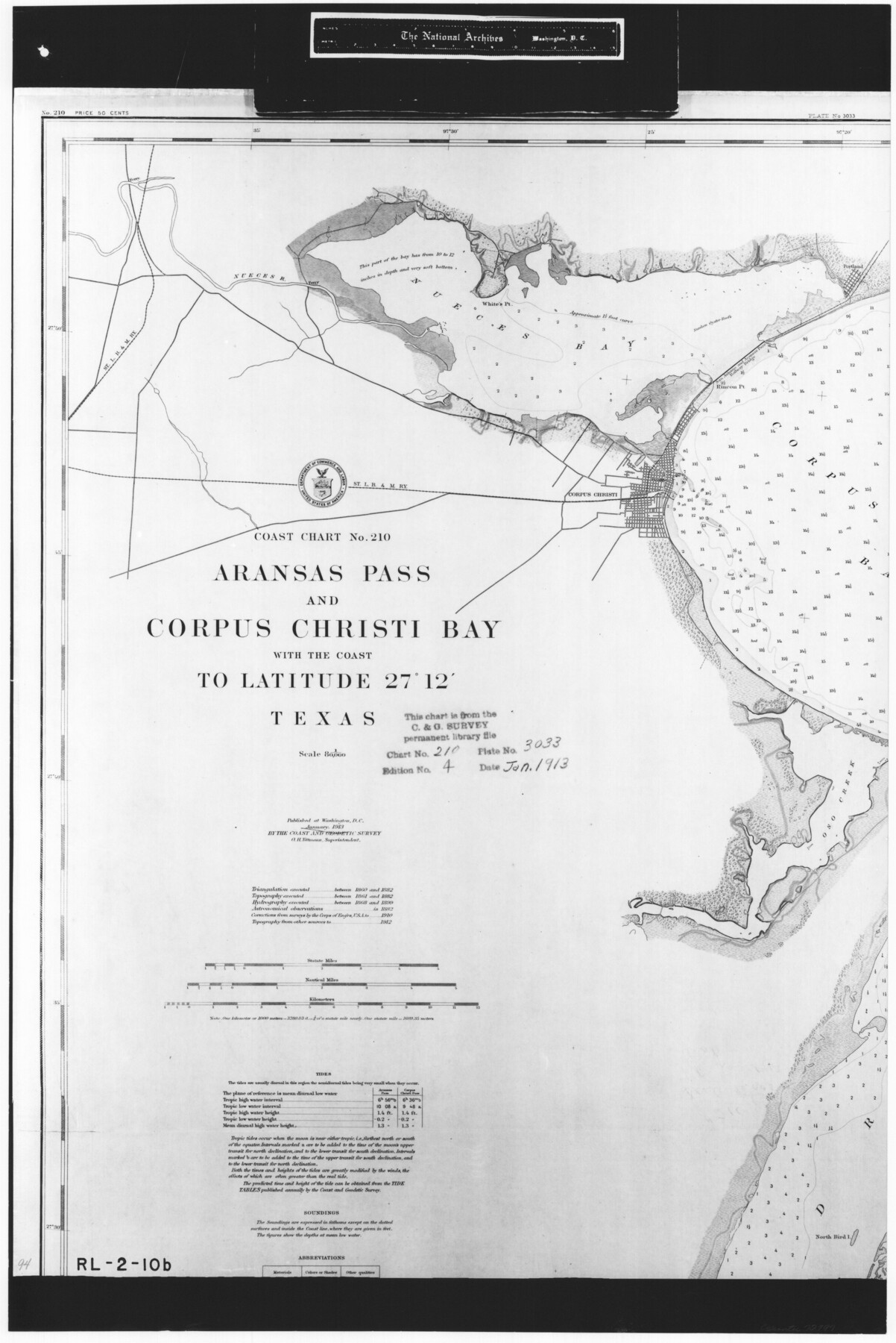
Coast Chart No. 210 Aransas Pass and Corpus Christi Bay with the coast to latitude 27° 12' Texas
RL-2-10b
-
Map/Doc
72797
-
Collection
General Map Collection
-
Object Dates
1913 (Creation Date)
-
People and Organizations
Coast and Geodetic Survey (Publisher)
-
Counties
Nueces
-
Subjects
Nautical Charts
-
Height x Width
27.4 x 18.3 inches
69.6 x 46.5 cm
-
Comments
B/W photostat copy from National Archives in multiple pieces.
Part of: General Map Collection
Knox County Rolled Sketch 19

Print $20.00
- Digital $50.00
Knox County Rolled Sketch 19
1952
Size 27.3 x 24.9 inches
Map/Doc 6559

Jeff Davis County Rolled Sketch 27

Print $20.00
- Digital $50.00
Jeff Davis County Rolled Sketch 27
1969
Size 29.3 x 36.8 inches
Map/Doc 6375
Controlled Mosaic by Jack Amman Photogrammetric Engineers, Inc - Sheet 32

Print $20.00
- Digital $50.00
Controlled Mosaic by Jack Amman Photogrammetric Engineers, Inc - Sheet 32
1954
Size 20.0 x 24.0 inches
Map/Doc 83485
Edwards County Sketch File VII

Print $8.00
- Digital $50.00
Edwards County Sketch File VII
1912
Size 8.8 x 4.1 inches
Map/Doc 21668
Wichita County Rolled Sketch 9A

Print $20.00
- Digital $50.00
Wichita County Rolled Sketch 9A
1917
Size 32.4 x 27.9 inches
Map/Doc 8247
Sutton County Sketch File 59

Print $20.00
- Digital $50.00
Sutton County Sketch File 59
Size 24.6 x 16.5 inches
Map/Doc 12394
[Surveys along the Leon River]
![20, [Surveys along the Leon River], General Map Collection](https://historictexasmaps.com/wmedia_w700/maps/20-1.tif.jpg)
Print $20.00
- Digital $50.00
[Surveys along the Leon River]
1840
Size 20.3 x 6.6 inches
Map/Doc 20
Tracing "A" [showing Rio Grande and settlements along river]
![72888, Tracing "A" [showing Rio Grande and settlements along river], General Map Collection](https://historictexasmaps.com/wmedia_w700/maps/72888.tif.jpg)
Print $20.00
- Digital $50.00
Tracing "A" [showing Rio Grande and settlements along river]
1881
Size 18.2 x 25.9 inches
Map/Doc 72888
Flight Mission No. CRC-4R, Frame 173, Chambers County

Print $20.00
- Digital $50.00
Flight Mission No. CRC-4R, Frame 173, Chambers County
1956
Size 18.7 x 22.3 inches
Map/Doc 84924
Sutton County Sketch File 18

Print $94.00
- Digital $50.00
Sutton County Sketch File 18
1893
Size 12.9 x 8.3 inches
Map/Doc 37410
Webb County Rolled Sketch 79

Print $20.00
- Digital $50.00
Webb County Rolled Sketch 79
2020
Size 35.7 x 24.9 inches
Map/Doc 95916
You may also like
Collingsworth County Working Sketch Graphic Index

Print $20.00
- Digital $50.00
Collingsworth County Working Sketch Graphic Index
1971
Size 41.0 x 34.8 inches
Map/Doc 76499
Lavaca County Rolled Sketch 6

Print $20.00
- Digital $50.00
Lavaca County Rolled Sketch 6
1986
Size 44.8 x 33.9 inches
Map/Doc 10290
Working Sketch in Dimmit Co.

Print $20.00
- Digital $50.00
Working Sketch in Dimmit Co.
1883
Size 14.9 x 14.6 inches
Map/Doc 436
Highland Place an Addition to City of Lubbock - Plat of Lots and Street

Print $20.00
- Digital $50.00
Highland Place an Addition to City of Lubbock - Plat of Lots and Street
Size 26.0 x 18.1 inches
Map/Doc 92843
Tom Green County Sketch File 79B

Print $20.00
- Digital $50.00
Tom Green County Sketch File 79B
1959
Size 18.5 x 23.8 inches
Map/Doc 12451
[Cotton Belt, St. Louis Southwestern Railway of Texas, Alignment through Smith County]
![64378, [Cotton Belt, St. Louis Southwestern Railway of Texas, Alignment through Smith County], General Map Collection](https://historictexasmaps.com/wmedia_w700/maps/64378.tif.jpg)
Print $20.00
- Digital $50.00
[Cotton Belt, St. Louis Southwestern Railway of Texas, Alignment through Smith County]
1903
Size 22.3 x 30.1 inches
Map/Doc 64378
Wichita County Rolled Sketch 13

Print $20.00
- Digital $50.00
Wichita County Rolled Sketch 13
Size 25.7 x 16.6 inches
Map/Doc 8250
Llano County Boundary File 2

Print $30.00
- Digital $50.00
Llano County Boundary File 2
Size 14.3 x 8.8 inches
Map/Doc 56443
Red River County

Print $20.00
- Digital $50.00
Red River County
1934
Size 45.0 x 38.6 inches
Map/Doc 77405
[River Secs. 55-79, Archer County School Land League 3 and surrounding surveys]
![90472, [River Secs. 55-79, Archer County School Land League 3 and surrounding surveys], Twichell Survey Records](https://historictexasmaps.com/wmedia_w700/maps/90472-1.tif.jpg)
Print $20.00
- Digital $50.00
[River Secs. 55-79, Archer County School Land League 3 and surrounding surveys]
Size 28.3 x 20.4 inches
Map/Doc 90472
Tom Green County Boundary File 6

Print $42.00
- Digital $50.00
Tom Green County Boundary File 6
Size 14.5 x 9.0 inches
Map/Doc 59376
Southern Pacific Lines in Texas and Louisiana (G. H. & S. A. Ry.) Circuit Plan of Automatic Block Signals, Automatic Train Control and Flatonia Interlocking Plant No. 3

Print $40.00
- Digital $50.00
Southern Pacific Lines in Texas and Louisiana (G. H. & S. A. Ry.) Circuit Plan of Automatic Block Signals, Automatic Train Control and Flatonia Interlocking Plant No. 3
1927
Size 43.5 x 215.5 inches
Map/Doc 90044