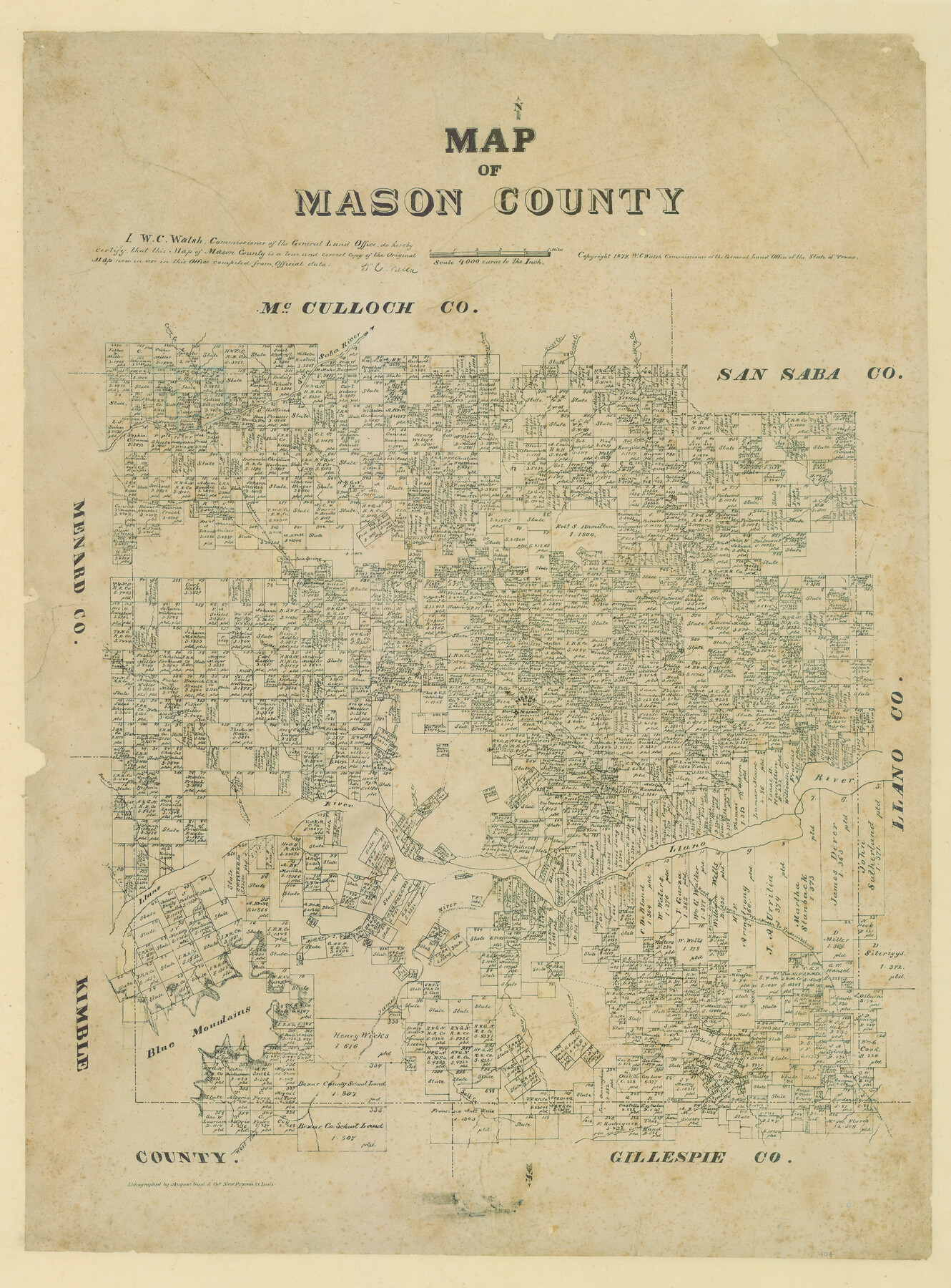
Map of Mason County, Texas
-
Map/Doc
404
-
Collection
Maddox Collection
-
Object Dates
1879 (Copyright Date)
-
People and Organizations
Charles Bierschwale (Publisher)
W.C. Walsh (GLO Commissioner)
-
Counties
Mason
-
Subjects
County
-
Height x Width
26.0 x 19.2 inches
66.0 x 48.8 cm
-
Medium
paper, etching/engraving/lithograph
-
Scale
1:4000
-
Comments
Conservation funded in 2008 by Friends of the Texas General Land Office.
-
Features
Llano River
West Ford [of James River]
Mesquite Creek
Salt Creek
Blue Mountains
James River
Schep Creek
Panther Creek
Willow Creek
Fredericksburg Road
Fort Mason Road
Road from Fort Mason to Fredericksburg
Honey Creek
Camp Creek
Donia Creek
Bear Creek
Salinas Creek
Middle Fork
Mason
Iron Mound
Fort Chadburn Road
Ranch Creek
Hackberry Creek
Tiger Creek
Kalemsy's Creek
San Saba River
Part of: Maddox Collection
Map of Shackelford County, Texas

Print $20.00
- Digital $50.00
Map of Shackelford County, Texas
1879
Size 28.7 x 23.4 inches
Map/Doc 616
Winkler County, Texas

Print $20.00
- Digital $50.00
Winkler County, Texas
1889
Size 24.6 x 19.0 inches
Map/Doc 658
Jasper County

Print $20.00
- Digital $50.00
Jasper County
1882
Size 17.6 x 14.0 inches
Map/Doc 75779
Map of Kinney County, Texas

Print $20.00
- Digital $50.00
Map of Kinney County, Texas
1879
Size 21.2 x 33.1 inches
Map/Doc 548
Map of the Western Part of Travis County, Texas

Print $20.00
- Digital $50.00
Map of the Western Part of Travis County, Texas
1919
Size 36.2 x 29.9 inches
Map/Doc 10754
Karnes County, Texas

Print $20.00
- Digital $50.00
Karnes County, Texas
1880
Size 28.9 x 23.0 inches
Map/Doc 524
Official Copy of the Map of Williamson County made for the International and G. N. R. R. Co.

Print $20.00
- Digital $50.00
Official Copy of the Map of Williamson County made for the International and G. N. R. R. Co.
1877
Size 23.3 x 28.4 inches
Map/Doc 672
Map of Kerr County, Texas

Print $20.00
- Digital $50.00
Map of Kerr County, Texas
1879
Size 21.7 x 28.5 inches
Map/Doc 526
Oldham County, Texas

Print $20.00
- Digital $50.00
Oldham County, Texas
1880
Size 21.2 x 26.8 inches
Map/Doc 745
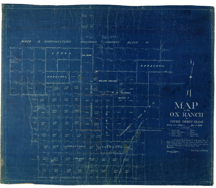
Map of the O-X Ranch in Cottle County, Texas
Print $20.00
- Digital $50.00
Map of the O-X Ranch in Cottle County, Texas
1916
Size 30.4 x 35.0 inches
Map/Doc 4438
Map of Lampasas County, Texas

Print $20.00
- Digital $50.00
Map of Lampasas County, Texas
1879
Size 23.4 x 28.4 inches
Map/Doc 560
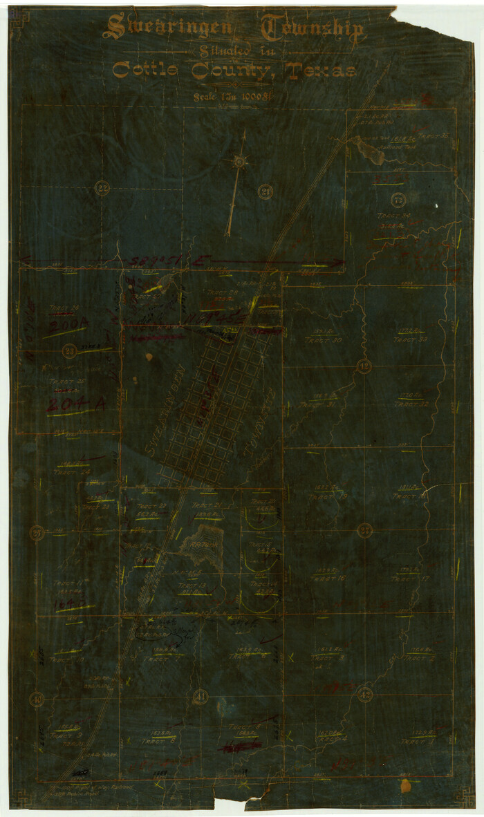
Swearingen Township situated in Cottle County, Texas
Print $20.00
- Digital $50.00
Swearingen Township situated in Cottle County, Texas
Size 26.4 x 15.7 inches
Map/Doc 4437
You may also like
Chambers County Working Sketch 29

Print $20.00
- Digital $50.00
Chambers County Working Sketch 29
2009
Size 25.2 x 18.6 inches
Map/Doc 89232

[Southwest corner of Runnels County School Land League 3]
![91586, [Southwest corner of Runnels County School Land League 3], Twichell Survey Records](https://historictexasmaps.com/wmedia_w700/maps/91586-1.tif.jpg)
Print $2.00
- Digital $50.00
[Southwest corner of Runnels County School Land League 3]
1927
Size 14.2 x 8.7 inches
Map/Doc 91586
Flight Mission No. DAG-26K, Frame 64, Matagorda County

Print $20.00
- Digital $50.00
Flight Mission No. DAG-26K, Frame 64, Matagorda County
1953
Size 18.5 x 22.2 inches
Map/Doc 86584
Harris County Working Sketch 22

Print $20.00
- Digital $50.00
Harris County Working Sketch 22
Size 17.5 x 22.0 inches
Map/Doc 65914
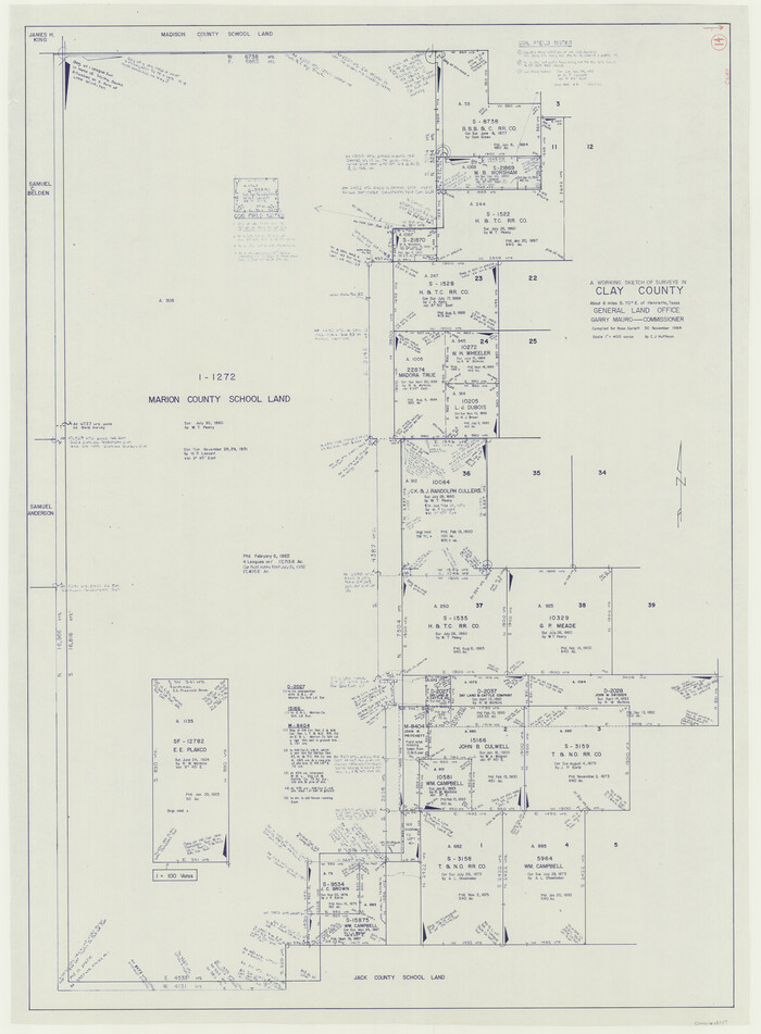
Clay County Working Sketch 14
Print $20.00
- Digital $50.00
Clay County Working Sketch 14
1984
Size 46.9 x 34.5 inches
Map/Doc 68037
Reeves County Working Sketch 30

Print $20.00
- Digital $50.00
Reeves County Working Sketch 30
1969
Size 31.1 x 36.5 inches
Map/Doc 63473
General Highway Map. Detail of Cities and Towns in Bell County, Texas [Belton and Rogers and vicinity]
![79369, General Highway Map. Detail of Cities and Towns in Bell County, Texas [Belton and Rogers and vicinity], Texas State Library and Archives](https://historictexasmaps.com/wmedia_w700/maps/79369.tif.jpg)
Print $20.00
General Highway Map. Detail of Cities and Towns in Bell County, Texas [Belton and Rogers and vicinity]
1961
Size 25.0 x 18.3 inches
Map/Doc 79369
Kendall County Working Sketch 18

Print $20.00
- Digital $50.00
Kendall County Working Sketch 18
1970
Size 43.2 x 33.3 inches
Map/Doc 66690
[Surveys on San Antonio River and Aransas Bay area]
![141, [Surveys on San Antonio River and Aransas Bay area], General Map Collection](https://historictexasmaps.com/wmedia_w700/maps/141.tif.jpg)
Print $20.00
- Digital $50.00
[Surveys on San Antonio River and Aransas Bay area]
1840
Size 24.1 x 33.0 inches
Map/Doc 141
Foard County Sketch File 33

Print $26.00
- Digital $50.00
Foard County Sketch File 33
1958
Size 11.4 x 8.9 inches
Map/Doc 22866
Dickens County Sketch File 2

Print $20.00
- Digital $50.00
Dickens County Sketch File 2
1913
Size 22.0 x 32.3 inches
Map/Doc 11316