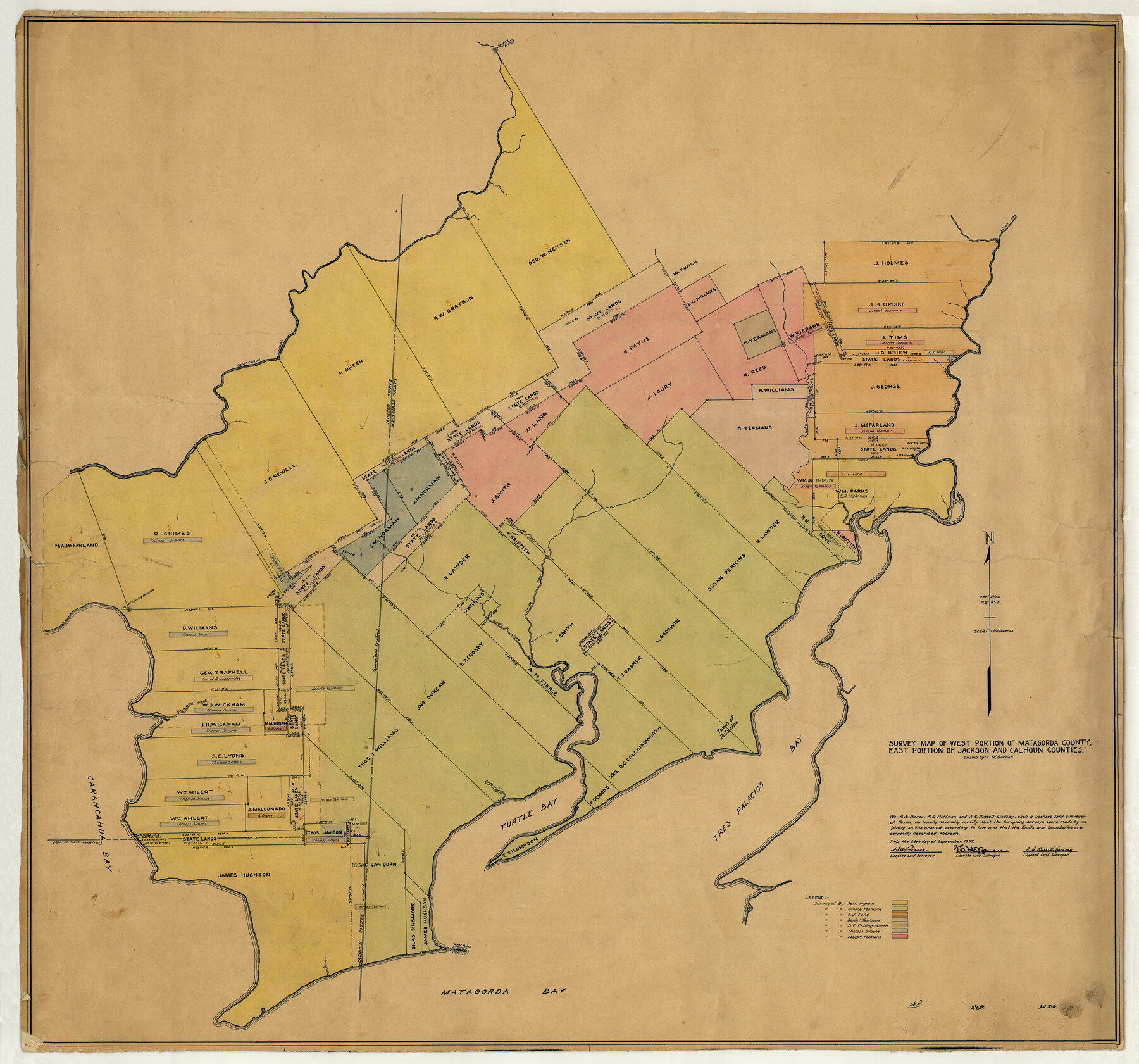
Matagorda County Rolled Sketch PHL1
Survey map of west portion of Matagorda County, east portion of Jackson and Calhoun Counties
-
Map/Doc
9477
-
Collection
General Map Collection
-
Object Dates
1937/10/26 (File Date)
-
People and Organizations
F.G. Hoffman (Surveyor/Engineer)
H.A. Pierce (Surveyor/Engineer)
A.C. Russell-Lindsay (Surveyor/Engineer)
C.M. Garner (Draftsman)
-
Counties
Matagorda
-
Subjects
Surveying Rolled Sketch
-
Height x Width
36.5 x 39.1 inches
92.7 x 99.3 cm
-
Medium
paper, manuscript
Part of: General Map Collection
Texas, San Bernard River, Cedar Lakes

Print $40.00
- Digital $50.00
Texas, San Bernard River, Cedar Lakes
1933
Size 26.7 x 48.6 inches
Map/Doc 69993
Refugio County Sketch File 27

Print $18.00
- Digital $50.00
Refugio County Sketch File 27
1993
Size 11.4 x 8.8 inches
Map/Doc 35294
[Surveys in the Jefferson District along Big Sandy Creek]
![100, [Surveys in the Jefferson District along Big Sandy Creek], General Map Collection](https://historictexasmaps.com/wmedia_w700/maps/100.tif.jpg)
Print $2.00
- Digital $50.00
[Surveys in the Jefferson District along Big Sandy Creek]
1841
Size 9.5 x 8.1 inches
Map/Doc 100
Loving County Rolled Sketch 15

Print $20.00
- Digital $50.00
Loving County Rolled Sketch 15
2015
Size 36.2 x 24.4 inches
Map/Doc 93793
[Map showing the location of the Pecos Valley Railway through H. &. G. N. R.R. Co. Land in Reeves Co., Texas]
![64707, [Map showing the location of the Pecos Valley Railway through H. &. G. N. R.R. Co. Land in Reeves Co., Texas], General Map Collection](https://historictexasmaps.com/wmedia_w700/maps/64707.tif.jpg)
Print $40.00
- Digital $50.00
[Map showing the location of the Pecos Valley Railway through H. &. G. N. R.R. Co. Land in Reeves Co., Texas]
1891
Size 39.1 x 123.6 inches
Map/Doc 64707
Capitol Land Reservation

Print $20.00
- Digital $50.00
Capitol Land Reservation
1880
Size 43.7 x 34.2 inches
Map/Doc 10745
Throckmorton County Working Sketch 6

Print $20.00
- Digital $50.00
Throckmorton County Working Sketch 6
1952
Size 24.7 x 21.7 inches
Map/Doc 62115
Irion County Working Sketch 7

Print $20.00
- Digital $50.00
Irion County Working Sketch 7
1936
Size 14.4 x 42.7 inches
Map/Doc 66416
Fractional Township No. 6 South Range No. 4 West of the Indian Meridian, Indian Territory

Print $20.00
- Digital $50.00
Fractional Township No. 6 South Range No. 4 West of the Indian Meridian, Indian Territory
1898
Size 19.2 x 24.4 inches
Map/Doc 75191
Culberson County Working Sketch 11

Print $20.00
- Digital $50.00
Culberson County Working Sketch 11
1920
Size 29.6 x 22.9 inches
Map/Doc 68463
Limestone County Sketch File 15

Print $8.00
- Digital $50.00
Limestone County Sketch File 15
1883
Size 12.7 x 8.0 inches
Map/Doc 30181
Flight Mission No. CON-2R, Frame 114, Stonewall County

Print $20.00
- Digital $50.00
Flight Mission No. CON-2R, Frame 114, Stonewall County
1957
Size 18.3 x 22.0 inches
Map/Doc 86989
You may also like
Culberson County Working Sketch 23

Print $20.00
- Digital $50.00
Culberson County Working Sketch 23
1945
Size 38.3 x 44.7 inches
Map/Doc 68476

Delta County Sketch File 1

Print $4.00
- Digital $50.00
Delta County Sketch File 1
1871
Size 12.7 x 8.1 inches
Map/Doc 20666
Galveston County NRC Article 33.136 Sketch 5

Print $20.00
- Digital $50.00
Galveston County NRC Article 33.136 Sketch 5
2001
Size 23.5 x 19.1 inches
Map/Doc 61587
Terrell County Working Sketch 29

Print $20.00
- Digital $50.00
Terrell County Working Sketch 29
1944
Size 28.6 x 35.5 inches
Map/Doc 62121
Smith County Rolled Sketch 6E2

Print $20.00
- Digital $50.00
Smith County Rolled Sketch 6E2
1960
Size 27.6 x 22.7 inches
Map/Doc 10613
Kent County Sketch File 8

Print $20.00
- Digital $50.00
Kent County Sketch File 8
Size 19.0 x 40.8 inches
Map/Doc 10515
[Sketch showing Blocks C-11, C-13, C-14, C-16, C-10]
![93123, [Sketch showing Blocks C-11, C-13, C-14, C-16, C-10], Twichell Survey Records](https://historictexasmaps.com/wmedia_w700/maps/93123-1.tif.jpg)
Print $40.00
- Digital $50.00
[Sketch showing Blocks C-11, C-13, C-14, C-16, C-10]
Size 69.9 x 22.5 inches
Map/Doc 93123
Anderson County Working Sketch 19

Print $20.00
- Digital $50.00
Anderson County Working Sketch 19
1951
Size 15.5 x 29.2 inches
Map/Doc 67019
[Texas Department of Corrections Prison Farm Locations]
![78638, [Texas Department of Corrections Prison Farm Locations], General Map Collection](https://historictexasmaps.com/wmedia_w700/maps/78638.tif.jpg)
Print $40.00
- Digital $50.00
[Texas Department of Corrections Prison Farm Locations]
Size 43.0 x 54.0 inches
Map/Doc 78638
Gray County Sketch File 1

Print $4.00
- Digital $50.00
Gray County Sketch File 1
1882
Size 10.4 x 7.2 inches
Map/Doc 24396
[Surveys along the Brazos River]
![39, [Surveys along the Brazos River], General Map Collection](https://historictexasmaps.com/wmedia_w700/maps/39.tif.jpg)
Print $3.00
- Digital $50.00
[Surveys along the Brazos River]
1840
Size 9.5 x 10.9 inches
Map/Doc 39