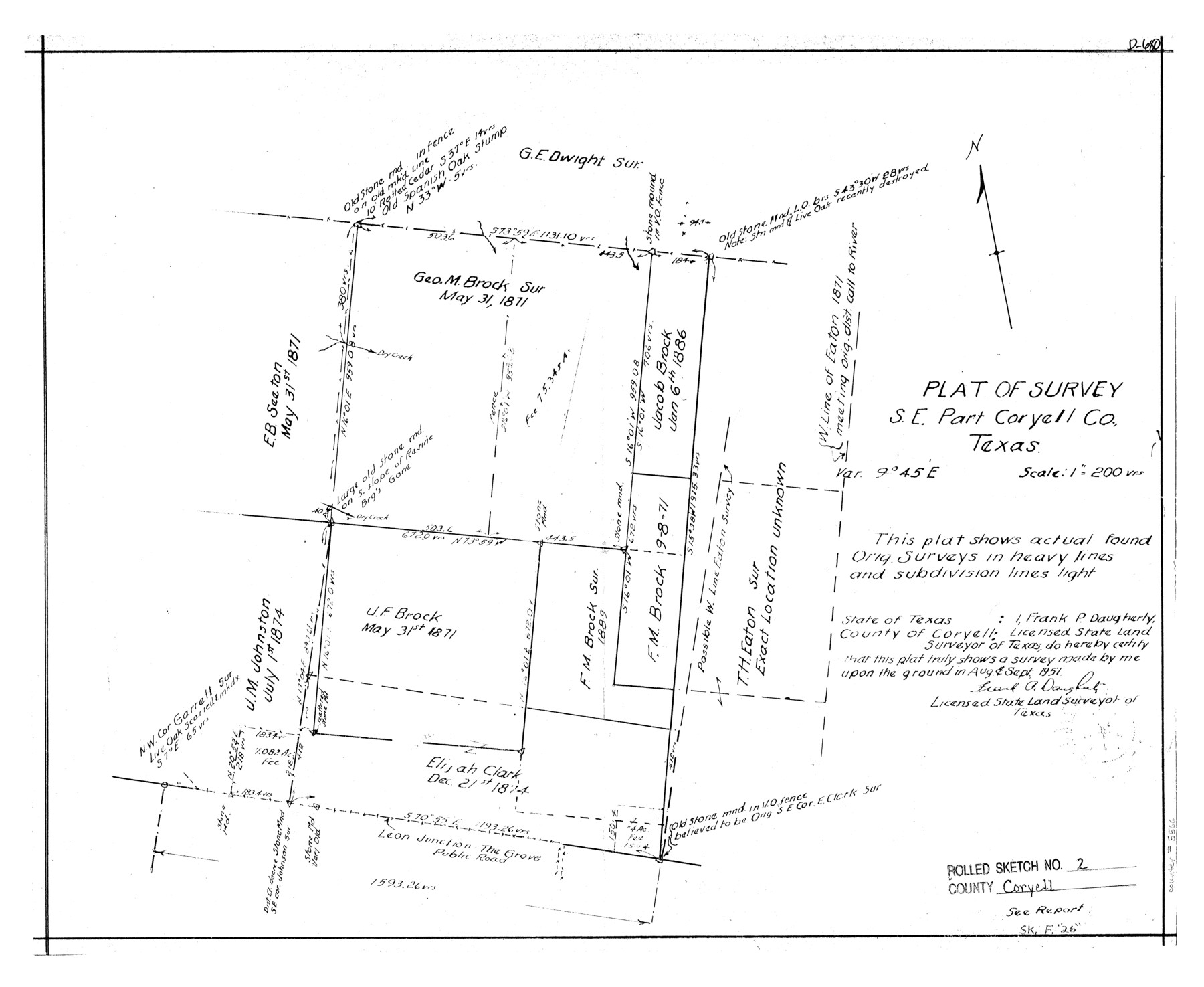
Coryell County Rolled Sketch 2
Plat of survey, S.E. part Coryell Co.
-
Map/Doc
5566
-
Collection
General Map Collection
-
Object Dates
1951/9/24 (Creation Date)
1951/9/29 (File Date)
-
People and Organizations
Frank P. Daugherty (Surveyor/Engineer)
-
Counties
Coryell
-
Subjects
Surveying Rolled Sketch
-
Height x Width
15.7 x 19.1 inches
39.9 x 48.5 cm
-
Scale
1" = 200 varas
-
Comments
See Coryell County Sketch File 26 (19393) for surveyor’s report.
Related maps
Coryell County Sketch File 26

Print $10.00
- Digital $50.00
Coryell County Sketch File 26
1951
Size 11.1 x 8.5 inches
Map/Doc 19393
Part of: General Map Collection
Reeves County

Print $20.00
- Digital $50.00
Reeves County
1945
Size 46.4 x 37.3 inches
Map/Doc 77406
Hopkins County Sketch File 15

Print $4.00
- Digital $50.00
Hopkins County Sketch File 15
Size 10.6 x 7.3 inches
Map/Doc 26711
The Land of Open Sky - Southwest U.S.A.

The Land of Open Sky - Southwest U.S.A.
Size 20.2 x 15.6 inches
Map/Doc 95945
Hays County Sketch File 33

Print $40.00
- Digital $50.00
Hays County Sketch File 33
1944
Size 16.4 x 15.1 inches
Map/Doc 26268
Eastland County Boundary File 13

Print $68.00
- Digital $50.00
Eastland County Boundary File 13
Size 8.0 x 3.7 inches
Map/Doc 52785
Dickens County Sketch File L

Print $22.00
- Digital $50.00
Dickens County Sketch File L
1909
Size 7.7 x 9.0 inches
Map/Doc 20892
Chambers County Rolled Sketch FD

Print $20.00
- Digital $50.00
Chambers County Rolled Sketch FD
1935
Size 32.7 x 26.5 inches
Map/Doc 5433
Parker County Sketch File 50

Print $68.00
- Digital $50.00
Parker County Sketch File 50
2022
Size 11.0 x 8.5 inches
Map/Doc 96679
J No. 5 - Reconnaissance of San Pedro Harbor, California

Print $20.00
- Digital $50.00
J No. 5 - Reconnaissance of San Pedro Harbor, California
1852
Size 12.3 x 15.5 inches
Map/Doc 97232
Fannin County Working Sketch 8

Print $20.00
- Digital $50.00
Fannin County Working Sketch 8
1955
Size 27.2 x 16.0 inches
Map/Doc 69162
McCulloch County Sketch File 6

Print $20.00
- Digital $50.00
McCulloch County Sketch File 6
1893
Size 44.2 x 19.3 inches
Map/Doc 10539
Jefferson County NRC Article 33.136 Sketch 11

Print $46.00
- Digital $50.00
Jefferson County NRC Article 33.136 Sketch 11
2012
Size 24.0 x 36.0 inches
Map/Doc 95011
You may also like
Mason County Rolled Sketch 4

Print $20.00
- Digital $50.00
Mason County Rolled Sketch 4
1983
Size 23.3 x 26.9 inches
Map/Doc 6677
Harris County Historic Topographic 21

Print $20.00
- Digital $50.00
Harris County Historic Topographic 21
1915
Size 29.2 x 22.5 inches
Map/Doc 65832
Trinity County Sketch File 24

Print $4.00
- Digital $50.00
Trinity County Sketch File 24
Size 7.5 x 10.5 inches
Map/Doc 38556
Zapata County Working Sketch 1

Print $20.00
- Digital $50.00
Zapata County Working Sketch 1
1912
Size 26.2 x 25.7 inches
Map/Doc 62052
Rail Road Map of the Southern States shewing the Southern & Southwestern Railway Connections with Philadelphia

Print $40.00
- Digital $50.00
Rail Road Map of the Southern States shewing the Southern & Southwestern Railway Connections with Philadelphia
1862
Size 31.6 x 54.1 inches
Map/Doc 97482

Webb County Working Sketch 48

Print $20.00
- Digital $50.00
Webb County Working Sketch 48
1948
Size 28.5 x 41.4 inches
Map/Doc 72413
Lamar County Working Sketch 10

Print $20.00
- Digital $50.00
Lamar County Working Sketch 10
1980
Size 18.6 x 15.4 inches
Map/Doc 70271
Reagan County

Print $20.00
- Digital $50.00
Reagan County
1903
Size 45.6 x 36.2 inches
Map/Doc 16794
Travis County Working Sketch Graphic Index - south part

Print $40.00
- Digital $50.00
Travis County Working Sketch Graphic Index - south part
1936
Size 42.6 x 52.8 inches
Map/Doc 76716
Llano County Working Sketch 11

Print $40.00
- Digital $50.00
Llano County Working Sketch 11
1983
Size 38.0 x 48.2 inches
Map/Doc 70629
Cass County Rolled Sketch BRR

Print $40.00
- Digital $50.00
Cass County Rolled Sketch BRR
1936
Size 67.3 x 28.0 inches
Map/Doc 8581