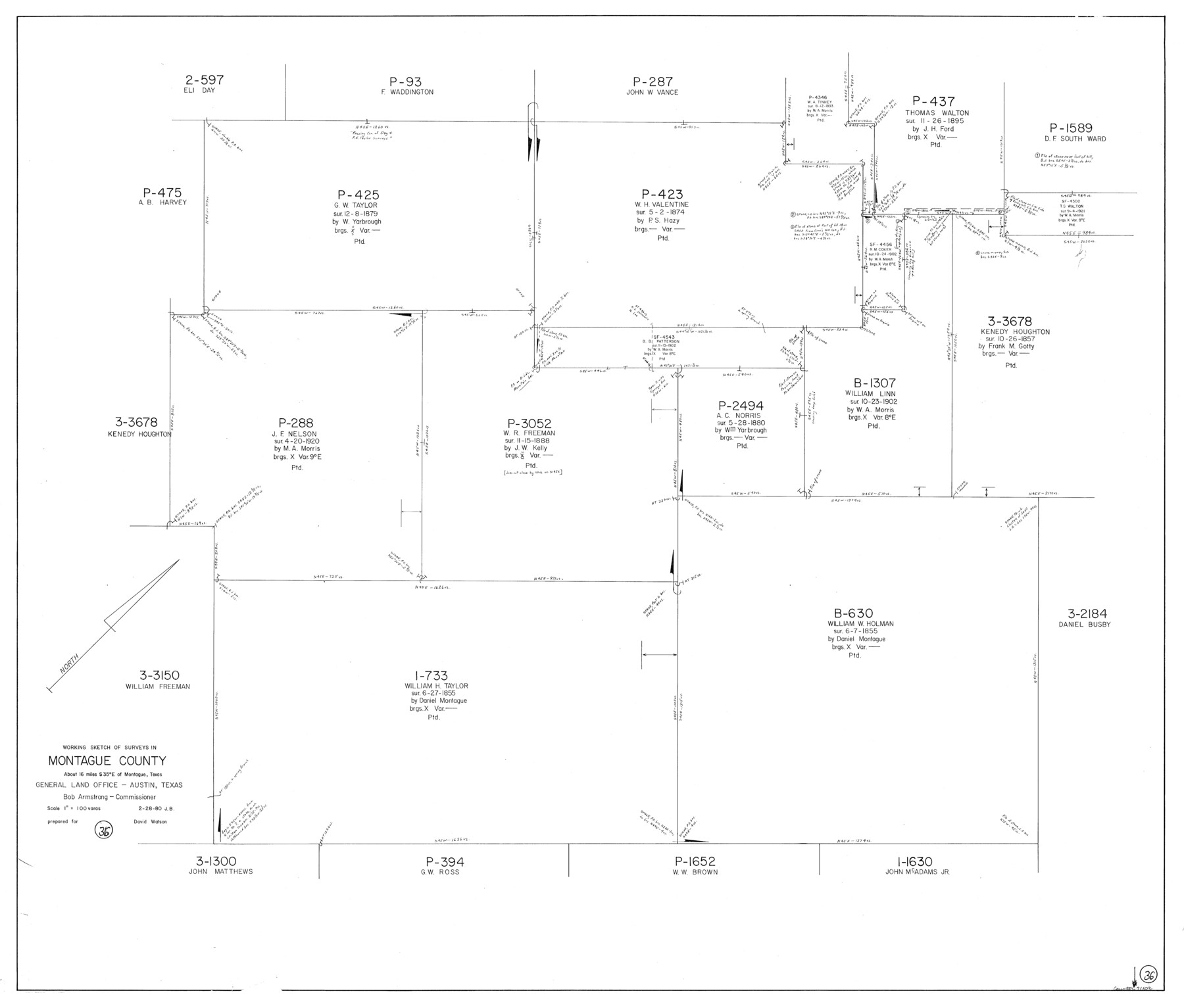
Montague County Working Sketch 36
-
Map/Doc
71102
-
Collection
General Map Collection
-
Object Dates
2/28/1980 (Creation Date)
-
People and Organizations
Jana Brod (Draftsman)
-
Counties
Montague
-
Subjects
Surveying Working Sketch
-
Height x Width
38.4 x 45.1 inches
97.5 x 114.6 cm
-
Scale
1" = 100 varas
Part of: General Map Collection

Coke County Sketch File 9

Print $4.00
- Digital $50.00
Coke County Sketch File 9
Size 12.6 x 7.9 inches
Map/Doc 18585
Loving County State of Texas

Print $20.00
- Digital $50.00
Loving County State of Texas
1889
Size 20.5 x 24.5 inches
Map/Doc 4581
Crockett County Working Sketch 43

Print $20.00
- Digital $50.00
Crockett County Working Sketch 43
1931
Size 26.1 x 21.7 inches
Map/Doc 68376
Montgomery County Working Sketch 48

Print $20.00
- Digital $50.00
Montgomery County Working Sketch 48
1958
Size 24.4 x 32.1 inches
Map/Doc 71155
Flight Mission No. DCL-7C, Frame 114, Kenedy County

Print $20.00
- Digital $50.00
Flight Mission No. DCL-7C, Frame 114, Kenedy County
1943
Size 18.6 x 22.2 inches
Map/Doc 86079
Flight Mission No. BQR-16K, Frame 35, Brazoria County

Print $20.00
- Digital $50.00
Flight Mission No. BQR-16K, Frame 35, Brazoria County
1952
Size 18.5 x 22.2 inches
Map/Doc 84102
Flight Mission No. DAH-9M, Frame 206, Orange County

Print $20.00
- Digital $50.00
Flight Mission No. DAH-9M, Frame 206, Orange County
1953
Size 18.7 x 22.7 inches
Map/Doc 86874
La Salle County Sketch File 25

Print $4.00
- Digital $50.00
La Salle County Sketch File 25
Size 7.5 x 14.2 inches
Map/Doc 29549
Lubbock County Working Sketch 3

Print $20.00
- Digital $50.00
Lubbock County Working Sketch 3
1904
Size 13.9 x 20.5 inches
Map/Doc 70663
Tyler County Sketch File 6-1

Print $6.00
- Digital $50.00
Tyler County Sketch File 6-1
1861
Size 13.3 x 9.3 inches
Map/Doc 38633
Navigation Maps of Gulf Intracoastal Waterway, Port Arthur to Brownsville, Texas

Print $20.00
- Digital $50.00
Navigation Maps of Gulf Intracoastal Waterway, Port Arthur to Brownsville, Texas
1951
Size 16.7 x 21.4 inches
Map/Doc 65417
You may also like
[Surveys along the Colorado and Navidad Rivers]
![60, [Surveys along the Colorado and Navidad Rivers], General Map Collection](https://historictexasmaps.com/wmedia_w700/maps/60.tif.jpg)
Print $20.00
- Digital $50.00
[Surveys along the Colorado and Navidad Rivers]
1840
Size 28.6 x 22.5 inches
Map/Doc 60
Montgomery County Sketch File 38

Print $8.00
- Digital $50.00
Montgomery County Sketch File 38
1899
Size 13.6 x 8.6 inches
Map/Doc 31919
Map of the City of Galveston Situated on the East end of Galveston Island

Print $20.00
- Digital $50.00
Map of the City of Galveston Situated on the East end of Galveston Island
1838
Size 22.0 x 38.1 inches
Map/Doc 2170
[Right of Way Map, Belton Branch of the M.K.&T. RR.]
![64715, [Right of Way Map, Belton Branch of the M.K.&T. RR.], General Map Collection](https://historictexasmaps.com/wmedia_w700/maps/64715-1.tif.jpg)
Print $2.00
- Digital $50.00
[Right of Way Map, Belton Branch of the M.K.&T. RR.]
1896
Size 11.1 x 8.3 inches
Map/Doc 64715
Atascosa County Sketch File 41a

Print $10.00
- Digital $50.00
Atascosa County Sketch File 41a
1956
Size 9.3 x 7.4 inches
Map/Doc 13841
Dallam County Boundary File 3

Print $40.00
- Digital $50.00
Dallam County Boundary File 3
Size 9.3 x 4.1 inches
Map/Doc 52062
Presidio County Sketch File 109

Print $6.00
- Digital $50.00
Presidio County Sketch File 109
Size 9.0 x 6.1 inches
Map/Doc 34815
Chambers County Rolled Sketch 17

Print $20.00
- Digital $50.00
Chambers County Rolled Sketch 17
1936
Size 38.0 x 32.8 inches
Map/Doc 5425
United States and Additions, 1820

Print $20.00
- Digital $50.00
United States and Additions, 1820
1820
Size 21.8 x 27.0 inches
Map/Doc 93798
Calhoun County NRC Article 33.136 Sketch 5

Print $34.00
- Digital $50.00
Calhoun County NRC Article 33.136 Sketch 5
2012
Size 24.0 x 36.0 inches
Map/Doc 94633
Wise County Sketch File 23

Print $4.00
- Digital $50.00
Wise County Sketch File 23
1859
Size 7.9 x 12.9 inches
Map/Doc 40568
Right of Way and Track Map, the Missouri, Kansas and Texas Ry. of Texas - Henrietta Division

Print $20.00
- Digital $50.00
Right of Way and Track Map, the Missouri, Kansas and Texas Ry. of Texas - Henrietta Division
1918
Size 11.8 x 26.8 inches
Map/Doc 64755