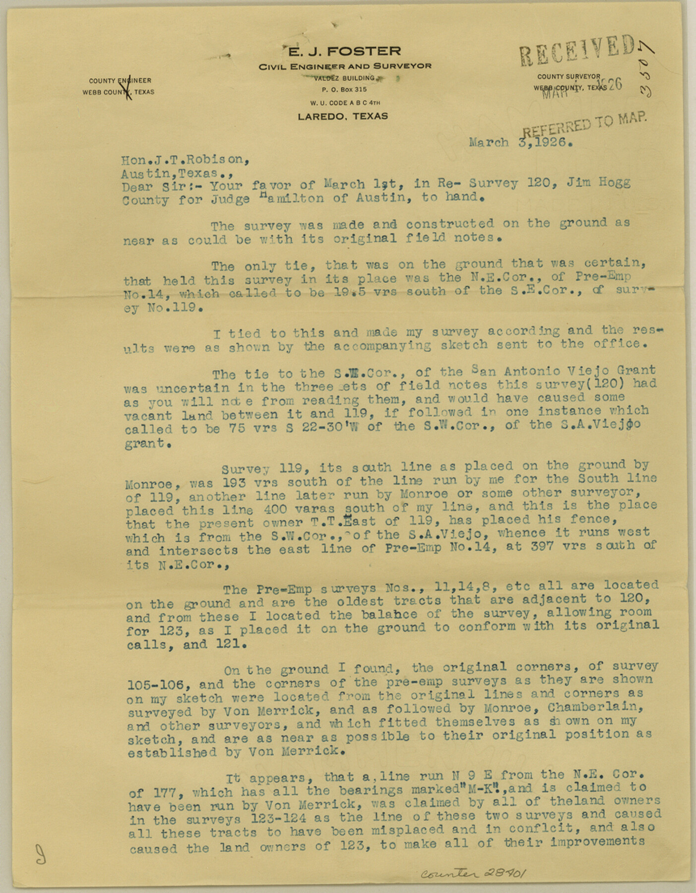
Jim Hogg County Sketch File 3
[Regarding corrections of no. 120, A. B. & M. in the southwest part of county]
-
Map/Doc
28401
-
Collection
General Map Collection
-
Object Dates
3/3/1926 (Creation Date)
3/4/1926 (File Date)
3/3/1926 (Correspondence Date)
-
People and Organizations
E.J. Foster (Surveyor/Engineer)
-
Counties
Jim Hogg
-
Subjects
Surveying Sketch File
-
Height x Width
11.0 x 8.6 inches
27.9 x 21.8 cm
-
Medium
paper, print
Part of: General Map Collection
Matagorda County Sketch File 39

Print $20.00
- Digital $50.00
Matagorda County Sketch File 39
Size 31.1 x 24.3 inches
Map/Doc 12047
Reconnaissance of the Coast of Texas between Matagorda and Corpus Christi Bays

Print $20.00
- Digital $50.00
Reconnaissance of the Coast of Texas between Matagorda and Corpus Christi Bays
1858
Size 25.2 x 21.4 inches
Map/Doc 75987
Bastrop County Sketch File 3

Print $4.00
- Digital $50.00
Bastrop County Sketch File 3
1860
Size 8.9 x 9.2 inches
Map/Doc 14044
Flight Mission No. CGI-1N, Frame 178, Cameron County

Print $20.00
- Digital $50.00
Flight Mission No. CGI-1N, Frame 178, Cameron County
1955
Size 18.6 x 22.3 inches
Map/Doc 84513
Flight Mission No. CRC-5R, Frame 19, Chambers County

Print $20.00
- Digital $50.00
Flight Mission No. CRC-5R, Frame 19, Chambers County
1956
Size 18.8 x 22.4 inches
Map/Doc 84941
Lavaca County Working Sketch 7

Print $20.00
- Digital $50.00
Lavaca County Working Sketch 7
1945
Size 23.6 x 26.2 inches
Map/Doc 70360
Supreme Court of the United States, October Term, 1924, No. 13, Original - The State of Oklahoma, Complainant vs. The State of Texas, Defendant, The United States, Intervener

Print $20.00
- Digital $50.00
Supreme Court of the United States, October Term, 1924, No. 13, Original - The State of Oklahoma, Complainant vs. The State of Texas, Defendant, The United States, Intervener
1924
Size 32.0 x 32.8 inches
Map/Doc 75132
Pecos County Working Sketch 98

Print $20.00
- Digital $50.00
Pecos County Working Sketch 98
1970
Size 42.8 x 31.8 inches
Map/Doc 71571
Galveston County Rolled Sketch 34D

Print $71.00
- Digital $50.00
Galveston County Rolled Sketch 34D
1981
Size 9.9 x 15.1 inches
Map/Doc 45171
Cameron County Working Sketch 3

Print $20.00
- Digital $50.00
Cameron County Working Sketch 3
1964
Size 40.8 x 38.6 inches
Map/Doc 67882
Northeast Part of Crockett County

Print $20.00
- Digital $50.00
Northeast Part of Crockett County
1976
Size 31.4 x 41.0 inches
Map/Doc 77253

You may also like
Wilbarger County Sketch File 26

Print $4.00
- Digital $50.00
Wilbarger County Sketch File 26
1885
Size 14.3 x 8.6 inches
Map/Doc 40227
Caldwell County

Print $20.00
- Digital $50.00
Caldwell County
1935
Size 37.8 x 42.0 inches
Map/Doc 73095
Flight Mission No. DCL-6C, Frame 65, Kenedy County

Print $20.00
- Digital $50.00
Flight Mission No. DCL-6C, Frame 65, Kenedy County
1943
Size 18.5 x 22.3 inches
Map/Doc 85907
Galveston County Sketch File 32

Print $20.00
- Digital $50.00
Galveston County Sketch File 32
1916
Size 15.2 x 34.3 inches
Map/Doc 11535
Hudspeth County Rolled Sketch 17

Print $40.00
- Digital $50.00
Hudspeth County Rolled Sketch 17
1886
Size 22.3 x 118.5 inches
Map/Doc 9203
Lynn County Working Sketch 3

Print $20.00
- Digital $50.00
Lynn County Working Sketch 3
1953
Size 30.8 x 30.9 inches
Map/Doc 70673
Flight Mission No. BRA-16M, Frame 62, Jefferson County

Print $20.00
- Digital $50.00
Flight Mission No. BRA-16M, Frame 62, Jefferson County
1953
Size 18.7 x 22.4 inches
Map/Doc 85679
McCulloch County Sketch File 5

Print $11.00
- Digital $50.00
McCulloch County Sketch File 5
1899
Size 17.5 x 9.2 inches
Map/Doc 31177
Duval County Sketch File 68

Print $20.00
- Digital $50.00
Duval County Sketch File 68
Size 23.9 x 19.6 inches
Map/Doc 11407
[Blocks 34-36, Township 1N]
![92031, [Blocks 34-36, Township 1N], Twichell Survey Records](https://historictexasmaps.com/wmedia_w700/maps/92031-1.tif.jpg)
Print $20.00
- Digital $50.00
[Blocks 34-36, Township 1N]
Size 36.8 x 23.8 inches
Map/Doc 92031
Cherokee County Sketch File 35

Print $42.00
- Digital $50.00
Cherokee County Sketch File 35
1955
Size 11.5 x 8.8 inches
Map/Doc 18204
Angelina County Sketch File 29

Print $4.00
- Digital $50.00
Angelina County Sketch File 29
1911
Size 8.0 x 8.4 inches
Map/Doc 13087