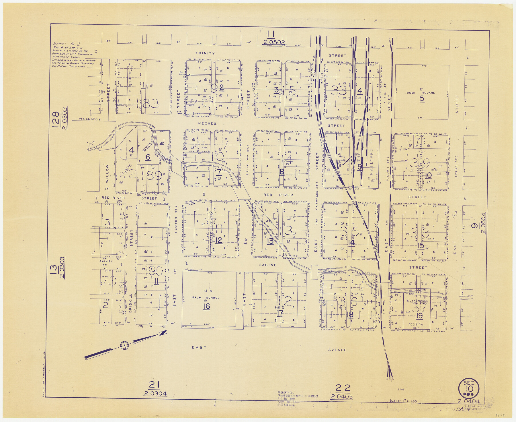
Travis County Appraisal District Plat Map 2_0404
Section 10
-
Map/Doc
94229
-
Collection
General Map Collection
-
Object Dates
1952 (Copy/Tracing Date)
1986 (Edition Date)
-
People and Organizations
Travis County Appraisal District (Publisher)
D. Redburn (Tracer)
-
Counties
Travis
-
Subjects
City
-
Height x Width
21.5 x 26.4 inches
54.6 x 67.1 cm
-
Medium
blueprint/diazo
-
Scale
1" = 100'
Part of: General Map Collection
Maverick County Sketch File 24

Print $36.00
- Digital $50.00
Maverick County Sketch File 24
1890
Size 9.1 x 8.7 inches
Map/Doc 31145
Louisiana and Texas Intracoastal Waterway - Dredging from Freeport Harbor to Caney Creek - Sheet 2

Print $20.00
- Digital $50.00
Louisiana and Texas Intracoastal Waterway - Dredging from Freeport Harbor to Caney Creek - Sheet 2
1940
Size 31.2 x 41.3 inches
Map/Doc 61817
Lynn County Rolled Sketch S

Print $20.00
- Digital $50.00
Lynn County Rolled Sketch S
Size 21.1 x 38.7 inches
Map/Doc 6654
Duval County Working Sketch 42

Print $20.00
- Digital $50.00
Duval County Working Sketch 42
1976
Size 24.9 x 31.1 inches
Map/Doc 68766
[The S.K. Ry. of Texas, State Line to Pecos, Reeves Co., Texas]
![64160, [The S.K. Ry. of Texas, State Line to Pecos, Reeves Co., Texas], General Map Collection](https://historictexasmaps.com/wmedia_w700/maps/64160.tif.jpg)
Print $40.00
- Digital $50.00
[The S.K. Ry. of Texas, State Line to Pecos, Reeves Co., Texas]
1910
Size 19.5 x 119.7 inches
Map/Doc 64160
Maps & Lists Showing Prison Lands (Oil & Gas) Leased as of June 1955

Digital $50.00
Maps & Lists Showing Prison Lands (Oil & Gas) Leased as of June 1955
Size 11.4 x 7.1 inches
Map/Doc 62866
Tarrant County Working Sketch 15

Print $20.00
- Digital $50.00
Tarrant County Working Sketch 15
1989
Size 33.0 x 38.3 inches
Map/Doc 62432

Harris County Sketch File 58

Print $20.00
- Digital $50.00
Harris County Sketch File 58
1920
Size 27.6 x 21.4 inches
Map/Doc 11657
Flight Mission No. BRA-6M, Frame 142, Jefferson County

Print $20.00
- Digital $50.00
Flight Mission No. BRA-6M, Frame 142, Jefferson County
1953
Size 18.6 x 22.3 inches
Map/Doc 85443
Schleicher County Working Sketch 8

Print $20.00
- Digital $50.00
Schleicher County Working Sketch 8
1923
Size 21.6 x 18.6 inches
Map/Doc 63810
Flight Mission No. CRC-4R, Frame 172, Chambers County

Print $20.00
- Digital $50.00
Flight Mission No. CRC-4R, Frame 172, Chambers County
1956
Size 18.6 x 22.3 inches
Map/Doc 84923
You may also like
Map of the country in the vicinity of San Antonio de Bexar reduced in part from the county map of Bexar with additions by J. Edmd. Blake, 1st Lieut Topl. Engs.

Print $20.00
- Digital $50.00
Map of the country in the vicinity of San Antonio de Bexar reduced in part from the county map of Bexar with additions by J. Edmd. Blake, 1st Lieut Topl. Engs.
1845
Size 18.3 x 26.1 inches
Map/Doc 72720
Comanche County Sketch File 1

Print $6.00
- Digital $50.00
Comanche County Sketch File 1
1847
Size 15.4 x 11.8 inches
Map/Doc 19051
County and Railroad Map of Texas

Print $20.00
- Digital $50.00
County and Railroad Map of Texas
1876
Size 17.0 x 16.0 inches
Map/Doc 93623
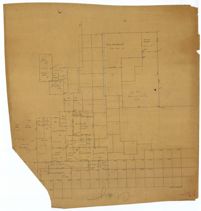
Clay County Working Sketch 1
Print $20.00
- Digital $50.00
Clay County Working Sketch 1
Size 30.7 x 29.3 inches
Map/Doc 68024
Johnson County Sketch File 3

Print $4.00
- Digital $50.00
Johnson County Sketch File 3
Size 10.1 x 8.0 inches
Map/Doc 28433
Menard County Sketch File 15

Print $8.00
- Digital $50.00
Menard County Sketch File 15
1892
Size 12.9 x 8.3 inches
Map/Doc 31510
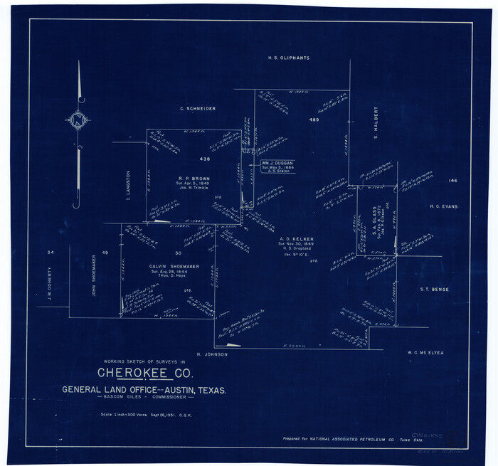
Cherokee County Working Sketch 5
Print $20.00
- Digital $50.00
Cherokee County Working Sketch 5
1951
Size 22.0 x 23.5 inches
Map/Doc 67960
Live Oak County Working Sketch 36

Print $20.00
- Digital $50.00
Live Oak County Working Sketch 36
2008
Size 33.5 x 35.8 inches
Map/Doc 88879
Kerr County Working Sketch 4

Print $20.00
- Digital $50.00
Kerr County Working Sketch 4
1946
Size 37.6 x 26.2 inches
Map/Doc 70035
Angelina County Sketch File 25

Print $8.00
- Digital $50.00
Angelina County Sketch File 25
1894
Size 7.0 x 10.2 inches
Map/Doc 13069
General Highway Map. Detail of Cities and Towns in Harris County, Texas. City Map [of] Houston, Pasadena, West University Place, Bellaire, Galena Park, Jacinto City, South Houston, South Side Place, Deer Park, and vicinity, Harris County, Texas
![79505, General Highway Map. Detail of Cities and Towns in Harris County, Texas. City Map [of] Houston, Pasadena, West University Place, Bellaire, Galena Park, Jacinto City, South Houston, South Side Place, Deer Park, and vicinity, Harris County, Texas, Texas State Library and Archives](https://historictexasmaps.com/wmedia_w700/maps/79505.tif.jpg)
Print $20.00
General Highway Map. Detail of Cities and Towns in Harris County, Texas. City Map [of] Houston, Pasadena, West University Place, Bellaire, Galena Park, Jacinto City, South Houston, South Side Place, Deer Park, and vicinity, Harris County, Texas
1961
Size 18.0 x 25.0 inches
Map/Doc 79505
Parker County Sketch File 18

Print $4.00
- Digital $50.00
Parker County Sketch File 18
1876
Size 8.9 x 6.3 inches
Map/Doc 33554