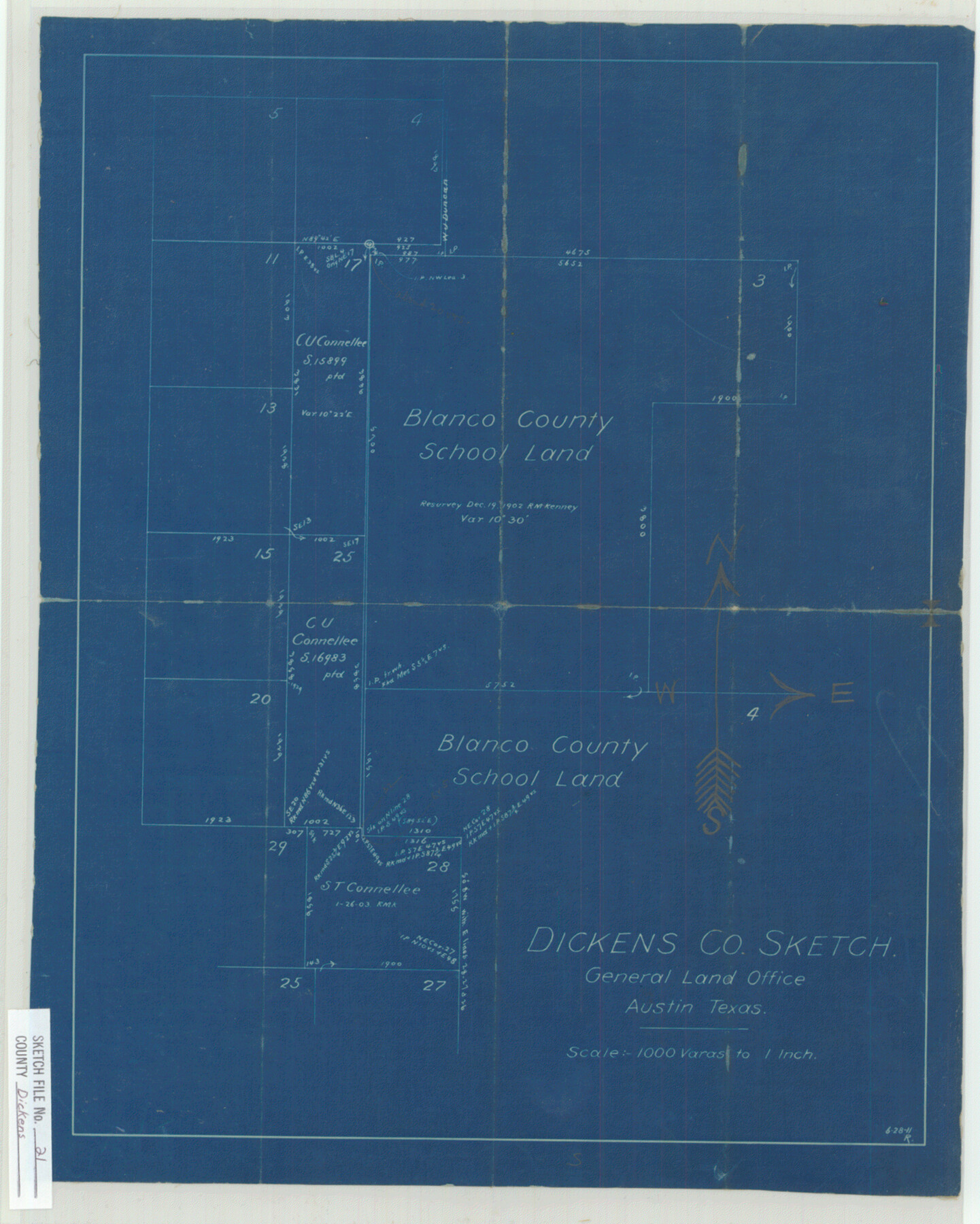
Dickens County Sketch File 21
NW pt. of County
-
Map/Doc
11324
-
Collection
General Map Collection
-
Object Dates
1911/6/28 (Creation Date)
1902/12/19 (Survey Date)
-
People and Organizations
Russell (Surveyor/Engineer)
R.M. Kenney (Surveyor/Engineer)
-
Counties
Dickens
-
Subjects
Surveying Sketch File
-
Height x Width
16.0 x 12.8 inches
40.6 x 32.5 cm
-
Medium
blueprint/diazo
-
Scale
1" = 1000 varas
Part of: General Map Collection
East Part of Edwards County

Print $20.00
- Digital $50.00
East Part of Edwards County
1975
Size 39.7 x 28.5 inches
Map/Doc 77270
Supreme Court of the United States, October Term, 1930, No.2, Original - The State of New Mexico, Complainant vs. The State of Texas, Defendant

Print $138.00
- Digital $50.00
Supreme Court of the United States, October Term, 1930, No.2, Original - The State of New Mexico, Complainant vs. The State of Texas, Defendant
Size 9.2 x 6.0 inches
Map/Doc 95287
St. Louis, Brownsville & Mexico

Print $40.00
- Digital $50.00
St. Louis, Brownsville & Mexico
1906
Size 20.0 x 127.8 inches
Map/Doc 89281
Flight Mission No. BQR-22K, Frame 42, Brazoria County

Print $20.00
- Digital $50.00
Flight Mission No. BQR-22K, Frame 42, Brazoria County
1953
Size 18.9 x 22.7 inches
Map/Doc 84126
Neches River, City of Lufkin

Print $20.00
- Digital $50.00
Neches River, City of Lufkin
1940
Size 37.5 x 29.7 inches
Map/Doc 65081
Clay County Boundary File 7

Print $14.00
- Digital $50.00
Clay County Boundary File 7
Size 14.3 x 8.8 inches
Map/Doc 51377
Flight Mission No. BRE-2P, Frame 41, Nueces County

Print $20.00
- Digital $50.00
Flight Mission No. BRE-2P, Frame 41, Nueces County
1956
Size 18.5 x 22.4 inches
Map/Doc 86743
Blanco County Sketch File 18

Print $4.00
- Digital $50.00
Blanco County Sketch File 18
1877
Size 12.6 x 8.5 inches
Map/Doc 14594
Eastland County Rolled Sketch 19

Print $20.00
- Digital $50.00
Eastland County Rolled Sketch 19
1980
Size 28.9 x 30.9 inches
Map/Doc 8825

Wise County Working Sketch 1

Print $20.00
- Digital $50.00
Wise County Working Sketch 1
1929
Size 22.4 x 19.4 inches
Map/Doc 72615
Coke County Rolled Sketch 18

Print $20.00
- Digital $50.00
Coke County Rolled Sketch 18
Size 43.4 x 34.4 inches
Map/Doc 8632
You may also like
[King, Knox & Stonewall Counties]
![92917, [King, Knox & Stonewall Counties], Twichell Survey Records](https://historictexasmaps.com/wmedia_w700/maps/92917-1.tif.jpg)
Print $20.00
- Digital $50.00
[King, Knox & Stonewall Counties]
1902
Size 19.6 x 28.2 inches
Map/Doc 92917
Map of Schleicher Co.

Print $20.00
- Digital $50.00
Map of Schleicher Co.
1891
Size 24.4 x 32.5 inches
Map/Doc 63024
Montague County Working Sketch 11

Print $20.00
- Digital $50.00
Montague County Working Sketch 11
1936
Size 33.8 x 21.3 inches
Map/Doc 71077
Flight Mission No. BRE-2P, Frame 54, Nueces County

Print $20.00
- Digital $50.00
Flight Mission No. BRE-2P, Frame 54, Nueces County
1956
Size 18.5 x 22.4 inches
Map/Doc 86756
Hill County Working Sketch Graphic Index

Print $20.00
- Digital $50.00
Hill County Working Sketch Graphic Index
1983
Size 39.8 x 46.9 inches
Map/Doc 76578
Newton County Sketch File 7

Print $4.00
- Digital $50.00
Newton County Sketch File 7
1872
Size 6.1 x 8.3 inches
Map/Doc 32374
Austin County Sketch File 10

Print $40.00
- Digital $50.00
Austin County Sketch File 10
1895
Size 25.5 x 21.0 inches
Map/Doc 10875
Randall County

Print $20.00
- Digital $50.00
Randall County
1958
Size 41.0 x 33.0 inches
Map/Doc 77402
Hudspeth County Working Sketch 56

Print $20.00
- Digital $50.00
Hudspeth County Working Sketch 56
1992
Size 40.7 x 31.1 inches
Map/Doc 66341
Young County Boundary File 1

Print $8.00
- Digital $50.00
Young County Boundary File 1
Size 10.3 x 8.2 inches
Map/Doc 60198
Matagorda County Sketch File 45

Print $206.00
- Digital $50.00
Matagorda County Sketch File 45
1967
Size 14.2 x 8.6 inches
Map/Doc 30876
[Sections 15, 16, 17, 18, Block B]
![92798, [Sections 15, 16, 17, 18, Block B], Twichell Survey Records](https://historictexasmaps.com/wmedia_w700/maps/92798-1.tif.jpg)
Print $20.00
- Digital $50.00
[Sections 15, 16, 17, 18, Block B]
Size 40.0 x 10.5 inches
Map/Doc 92798