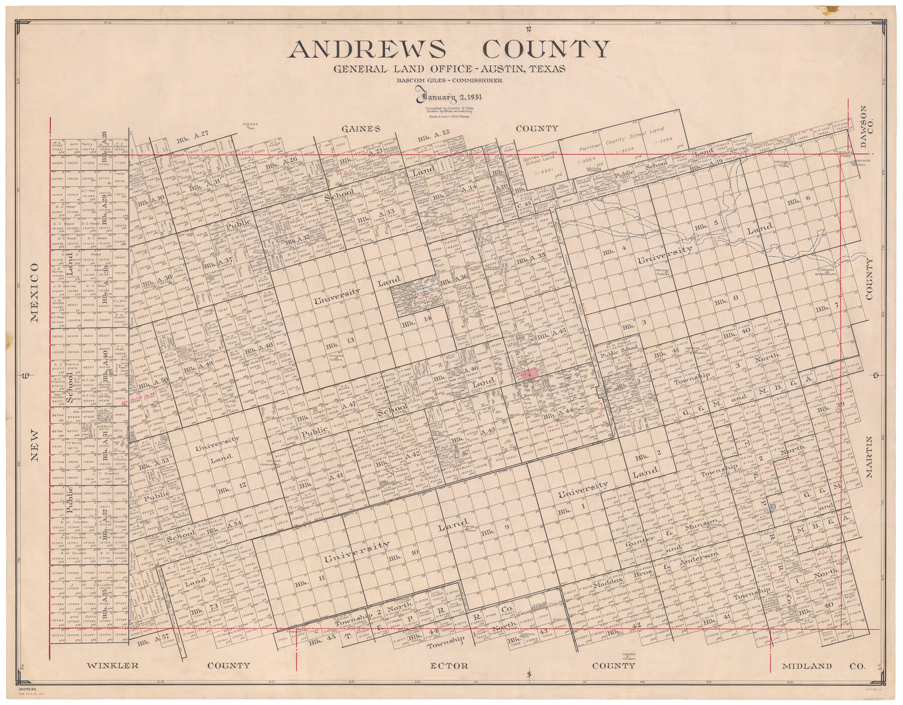
Andrews County
-
Map/Doc
73067
-
Collection
General Map Collection
-
Object Dates
1951/1/2 (Creation Date)
-
People and Organizations
Texas General Land Office (Publisher)
Eltea Armstrong (Draftsman)
Bascom Giles (GLO Commissioner)
Curtis R. Hale (Compiler)
-
Counties
Andrews
-
Subjects
County
-
Height x Width
42.7 x 54.4 inches
108.5 x 138.2 cm
-
Features
Shafters Lake
Andrews
Baird Lake
Part of: General Map Collection
[Sketch for Mineral Applications 26885-6 - Reagan and Crockett Cos., W. H. Bland]
![2854, [Sketch for Mineral Applications 26885-6 - Reagan and Crockett Cos., W. H. Bland], General Map Collection](https://historictexasmaps.com/wmedia_w700/maps/2854.tif.jpg)
Print $20.00
- Digital $50.00
[Sketch for Mineral Applications 26885-6 - Reagan and Crockett Cos., W. H. Bland]
1932
Size 41.5 x 36.6 inches
Map/Doc 2854
Van Zandt County Rolled Sketch 8

Print $20.00
- Digital $50.00
Van Zandt County Rolled Sketch 8
1948
Size 38.4 x 23.9 inches
Map/Doc 8148
Marion County Working Sketch 22

Print $20.00
- Digital $50.00
Marion County Working Sketch 22
1960
Size 34.3 x 27.5 inches
Map/Doc 70798
Starr County Sketch File 50

Print $40.00
- Digital $50.00
Starr County Sketch File 50
1963
Size 12.4 x 15.5 inches
Map/Doc 37007
Upton County Boundary File 2

Print $6.00
- Digital $50.00
Upton County Boundary File 2
Size 14.4 x 8.9 inches
Map/Doc 59517
Milam County Boundary File 6c

Print $2.00
- Digital $50.00
Milam County Boundary File 6c
Size 11.2 x 8.5 inches
Map/Doc 57250
Flight Mission No. DCL-6C, Frame 68, Kenedy County

Print $20.00
- Digital $50.00
Flight Mission No. DCL-6C, Frame 68, Kenedy County
1943
Size 18.6 x 22.4 inches
Map/Doc 85910
Harris County Working Sketch 32

Print $20.00
- Digital $50.00
Harris County Working Sketch 32
1936
Size 34.7 x 41.8 inches
Map/Doc 65924
Presidio County Sketch File 91

Print $40.00
- Digital $50.00
Presidio County Sketch File 91
Size 12.3 x 15.9 inches
Map/Doc 34763
Flight Mission No. CGI-1N, Frame 182, Cameron County

Print $20.00
- Digital $50.00
Flight Mission No. CGI-1N, Frame 182, Cameron County
1955
Size 18.6 x 22.3 inches
Map/Doc 84517
Mills County Sketch File 26

Print $4.00
- Digital $50.00
Mills County Sketch File 26
1998
Size 14.3 x 8.8 inches
Map/Doc 31678
Current Miscellaneous File 56

Print $10.00
- Digital $50.00
Current Miscellaneous File 56
1954
Size 12.2 x 9.2 inches
Map/Doc 74045
You may also like
Clay County Sketch File 45

Print $20.00
- Digital $50.00
Clay County Sketch File 45
Size 23.5 x 35.4 inches
Map/Doc 11097
Wilbarger County Working Sketch 21

Print $20.00
- Digital $50.00
Wilbarger County Working Sketch 21
1979
Size 37.4 x 37.8 inches
Map/Doc 72559
North end of Brazos Island

Print $20.00
- Digital $50.00
North end of Brazos Island
Size 25.9 x 18.2 inches
Map/Doc 72917
Gaines County Working Sketch 16

Print $20.00
- Digital $50.00
Gaines County Working Sketch 16
1959
Size 42.4 x 37.3 inches
Map/Doc 69316

Crockett County Rolled Sketch 31

Print $40.00
- Digital $50.00
Crockett County Rolled Sketch 31
Size 58.1 x 50.0 inches
Map/Doc 8716
Sketch from Reeves and Pecos Co's.

Print $20.00
- Digital $50.00
Sketch from Reeves and Pecos Co's.
Size 35.1 x 26.1 inches
Map/Doc 91779
General Highway Map, Val Verde County, Texas

Print $20.00
General Highway Map, Val Verde County, Texas
1961
Size 24.9 x 18.1 inches
Map/Doc 79694
Kimble County Working Sketch 48

Print $20.00
- Digital $50.00
Kimble County Working Sketch 48
1951
Size 23.2 x 22.1 inches
Map/Doc 70116
Crockett County Working Sketch 39

Print $20.00
- Digital $50.00
Crockett County Working Sketch 39
1928
Size 14.7 x 22.2 inches
Map/Doc 68372
Harris County Boundary File 39 (15)

Print $8.00
- Digital $50.00
Harris County Boundary File 39 (15)
Size 7.2 x 8.3 inches
Map/Doc 54350
Zapata County

Print $40.00
- Digital $50.00
Zapata County
1935
Size 55.8 x 41.1 inches
Map/Doc 77467