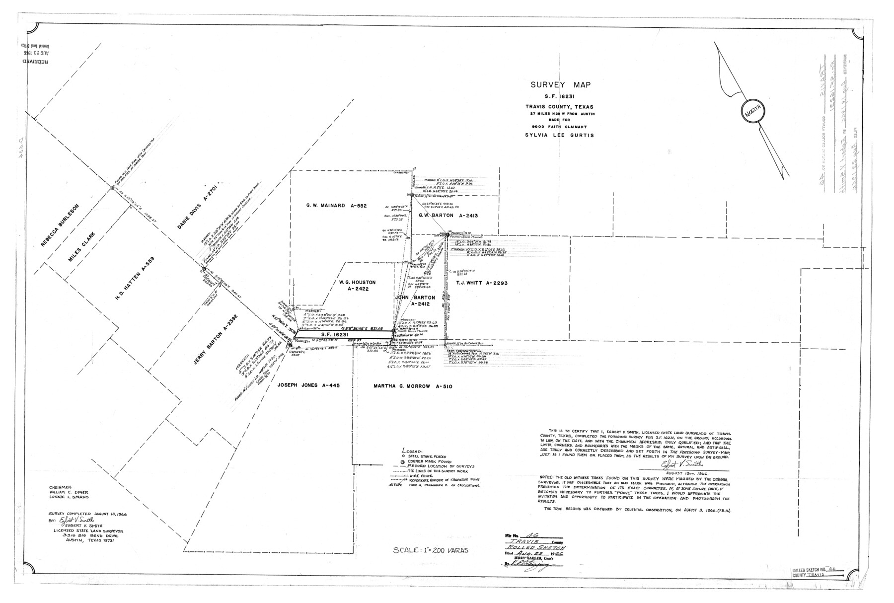
Travis County Rolled Sketch 46
Survey map, SF-16231, Travis County, Texas
-
Map/Doc
8043
-
Collection
General Map Collection
-
Object Dates
1966/8/13 (Survey Date)
1966/8/23 (File Date)
1966/8/19 (Creation Date)
-
People and Organizations
Egbert V. Smith (Surveyor/Engineer)
William E. Egger (Chainman/Field Personnel)
Lonnie L. Sparks (Chainman/Field Personnel)
-
Counties
Travis
-
Subjects
Surveying Rolled Sketch
-
Height x Width
25.4 x 37.6 inches
64.5 x 95.5 cm
-
Scale
1" = 200 varas
Part of: General Map Collection
Harbor of Brazos Santiago, Texas

Print $20.00
- Digital $50.00
Harbor of Brazos Santiago, Texas
1887
Size 27.1 x 18.3 inches
Map/Doc 72994
Flight Mission No. DAH-17M, Frame 29, Orange County

Print $20.00
- Digital $50.00
Flight Mission No. DAH-17M, Frame 29, Orange County
1953
Size 18.7 x 22.5 inches
Map/Doc 86892
[Maps of surveys in Reeves & Culberson Cos]
![61142, [Maps of surveys in Reeves & Culberson Cos], General Map Collection](https://historictexasmaps.com/wmedia_w700/maps/61142.tif.jpg)
Print $20.00
- Digital $50.00
[Maps of surveys in Reeves & Culberson Cos]
1937
Size 30.6 x 24.8 inches
Map/Doc 61142
Austin County

Print $20.00
- Digital $50.00
Austin County
1943
Size 40.1 x 42.5 inches
Map/Doc 73073

Travis County Rolled Sketch 16

Print $20.00
- Digital $50.00
Travis County Rolled Sketch 16
1940
Size 21.0 x 18.4 inches
Map/Doc 8018
Wichita County Boundary File 3

Print $40.00
- Digital $50.00
Wichita County Boundary File 3
Size 9.0 x 52.8 inches
Map/Doc 59913
Gillespie County Rolled Sketch O

Print $20.00
- Digital $50.00
Gillespie County Rolled Sketch O
1846
Size 42.6 x 20.0 inches
Map/Doc 6007
Flight Mission No. DCL-6C, Frame 4, Kenedy County

Print $20.00
- Digital $50.00
Flight Mission No. DCL-6C, Frame 4, Kenedy County
1943
Size 18.7 x 22.3 inches
Map/Doc 85864
Polk County Working Sketch 33b

Print $20.00
- Digital $50.00
Polk County Working Sketch 33b
1960
Size 14.9 x 24.8 inches
Map/Doc 71650
Sherman County Boundary File 4

Print $54.00
- Digital $50.00
Sherman County Boundary File 4
Size 8.9 x 8.5 inches
Map/Doc 58782
Duval County Boundary File 3g

Print $4.00
- Digital $50.00
Duval County Boundary File 3g
Size 9.9 x 7.8 inches
Map/Doc 52747
You may also like
Aransas County Rolled Sketch 4

Print $20.00
- Digital $50.00
Aransas County Rolled Sketch 4
1952
Size 28.9 x 26.4 inches
Map/Doc 77189
Farmer Subdivision of Wm. Baker Survey

Print $20.00
- Digital $50.00
Farmer Subdivision of Wm. Baker Survey
Size 16.1 x 15.5 inches
Map/Doc 90122
Dawson County Working Sketch Graphic Index

Print $20.00
- Digital $50.00
Dawson County Working Sketch Graphic Index
1959
Size 40.7 x 33.4 inches
Map/Doc 76518
Jack County Working Sketch 6

Print $20.00
- Digital $50.00
Jack County Working Sketch 6
1952
Size 29.1 x 24.3 inches
Map/Doc 66432
Young County Working Sketch 6

Print $20.00
- Digital $50.00
Young County Working Sketch 6
1919
Size 12.2 x 11.9 inches
Map/Doc 62029
Map of the Northern Part of Houston District

Print $20.00
- Digital $50.00
Map of the Northern Part of Houston District
1849
Size 26.4 x 26.7 inches
Map/Doc 3223
Newton County Working Sketch 36

Print $20.00
- Digital $50.00
Newton County Working Sketch 36
1960
Size 29.9 x 39.1 inches
Map/Doc 71282
Hood County Sketch File 1

Print $5.00
- Digital $50.00
Hood County Sketch File 1
Size 11.0 x 15.2 inches
Map/Doc 26569
Webb County Sketch File 5

Print $8.00
- Digital $50.00
Webb County Sketch File 5
1876
Size 12.8 x 8.1 inches
Map/Doc 39725
Outer Continental Shelf Leasing Maps (Texas Offshore Operations)

Print $20.00
- Digital $50.00
Outer Continental Shelf Leasing Maps (Texas Offshore Operations)
Size 17.6 x 13.6 inches
Map/Doc 75850
Hutchinson County Rolled Sketch 44-12

Print $20.00
- Digital $50.00
Hutchinson County Rolled Sketch 44-12
2002
Size 24.0 x 36.0 inches
Map/Doc 77548
Culberson County Working Sketch 39

Print $40.00
- Digital $50.00
Culberson County Working Sketch 39
1966
Size 37.9 x 82.7 inches
Map/Doc 68492