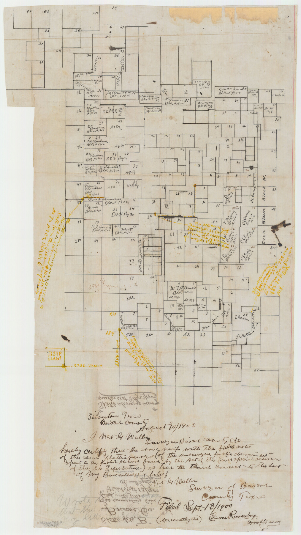
Briscoe County Sketch File B
[Connecting line and sketch of large area in central eastern portion of Briscoe County]
-
Map/Doc
10998
-
Collection
General Map Collection
-
Object Dates
1900/8/10 (Creation Date)
1900/9/13 (File Date)
-
People and Organizations
Nat G. Waller (Surveyor/Engineer)
-
Counties
Briscoe
-
Subjects
Surveying Sketch File
-
Height x Width
23.6 x 37.0 inches
59.9 x 94.0 cm
-
Medium
paper, manuscript
Part of: General Map Collection
Carte d'une partie des Côtes de l'Inde depuis Bombay jus'qu'a Surate, avec le détail des Habitations de cette Côte

Print $20.00
- Digital $50.00
Carte d'une partie des Côtes de l'Inde depuis Bombay jus'qu'a Surate, avec le détail des Habitations de cette Côte
1782
Size 13.2 x 18.2 inches
Map/Doc 97119
Chambers County Rolled Sketch 14

Print $20.00
- Digital $50.00
Chambers County Rolled Sketch 14
1935
Size 33.3 x 41.7 inches
Map/Doc 8616
Flight Mission No. DAG-24K, Frame 124, Matagorda County

Print $20.00
- Digital $50.00
Flight Mission No. DAG-24K, Frame 124, Matagorda County
1953
Size 18.4 x 22.3 inches
Map/Doc 86542
Eastland County Working Sketch 41

Print $20.00
- Digital $50.00
Eastland County Working Sketch 41
1975
Size 37.3 x 34.7 inches
Map/Doc 68822
San Patricio County Working Sketch 23

Print $20.00
- Digital $50.00
San Patricio County Working Sketch 23
1984
Size 43.5 x 43.8 inches
Map/Doc 63785
Jim Hogg Co. [and] Brooks Co.
![4756, Jim Hogg Co. [and] Brooks Co., General Map Collection](https://historictexasmaps.com/wmedia_w700/maps/4756.tif.jpg)
Print $20.00
- Digital $50.00
Jim Hogg Co. [and] Brooks Co.
1913
Size 31.8 x 41.8 inches
Map/Doc 4756
Armstrong County Working Sketch 11

Print $20.00
- Digital $50.00
Armstrong County Working Sketch 11
2025
Map/Doc 97507
[Right of Way & Track Map, The Texas & Pacific Ry. Co. Main Line]
![64665, [Right of Way & Track Map, The Texas & Pacific Ry. Co. Main Line], General Map Collection](https://historictexasmaps.com/wmedia_w700/maps/64665.tif.jpg)
Print $20.00
- Digital $50.00
[Right of Way & Track Map, The Texas & Pacific Ry. Co. Main Line]
Size 11.0 x 18.4 inches
Map/Doc 64665
Harris County Rolled Sketch 72

Print $40.00
- Digital $50.00
Harris County Rolled Sketch 72
1945
Size 23.0 x 48.3 inches
Map/Doc 9132
Sutton County

Print $40.00
- Digital $50.00
Sutton County
1898
Size 41.1 x 58.3 inches
Map/Doc 78392
Kent County Boundary File 5

Print $6.00
- Digital $50.00
Kent County Boundary File 5
Size 8.6 x 8.6 inches
Map/Doc 55865
Flight Mission No. BRE-2P, Frame 66, Nueces County

Print $20.00
- Digital $50.00
Flight Mission No. BRE-2P, Frame 66, Nueces County
1956
Size 18.6 x 22.5 inches
Map/Doc 86761
You may also like
Mills County Working Sketch 12

Print $20.00
- Digital $50.00
Mills County Working Sketch 12
1923
Size 22.1 x 26.3 inches
Map/Doc 71042
Crockett County Working Sketch 11

Print $40.00
- Digital $50.00
Crockett County Working Sketch 11
1913
Size 47.9 x 33.5 inches
Map/Doc 68344
Wharton County Sketch File 6

Print $4.00
- Digital $50.00
Wharton County Sketch File 6
1877
Size 8.6 x 14.2 inches
Map/Doc 39923
Flight Mission No. DQN-7K, Frame 91, Calhoun County

Print $20.00
- Digital $50.00
Flight Mission No. DQN-7K, Frame 91, Calhoun County
1953
Size 18.4 x 22.2 inches
Map/Doc 84482
Brooks County Working Sketch 4

Print $20.00
- Digital $50.00
Brooks County Working Sketch 4
1906
Size 28.6 x 24.9 inches
Map/Doc 67788
Carta Particular de la Parte sur del Seno Mexicano que comprehende las Cóstas de Yucatan y Sonda de Campeche, las de Tabasco, Veracruz y Tamaulipas

Carta Particular de la Parte sur del Seno Mexicano que comprehende las Cóstas de Yucatan y Sonda de Campeche, las de Tabasco, Veracruz y Tamaulipas
1825
Size 26.6 x 38.5 inches
Map/Doc 94567
Hood County Sketch File 7

Print $6.00
- Digital $50.00
Hood County Sketch File 7
Size 12.9 x 7.9 inches
Map/Doc 26581
Flight Mission No. DQO-3K, Frame 80, Galveston County

Print $20.00
- Digital $50.00
Flight Mission No. DQO-3K, Frame 80, Galveston County
1952
Size 18.7 x 22.5 inches
Map/Doc 85085
Kleberg County Aerial Photograph Index Sheet 4

Print $20.00
- Digital $50.00
Kleberg County Aerial Photograph Index Sheet 4
1956
Size 19.3 x 23.3 inches
Map/Doc 83721
Gregg County Rolled Sketch TMB

Print $20.00
- Digital $50.00
Gregg County Rolled Sketch TMB
1931
Size 20.9 x 20.8 inches
Map/Doc 6042
Dickens County Working Sketch Graphic Index

Print $20.00
- Digital $50.00
Dickens County Working Sketch Graphic Index
1963
Size 42.5 x 33.6 inches
Map/Doc 76523
Menard County Sketch File 5

Print $20.00
- Digital $50.00
Menard County Sketch File 5
Size 5.6 x 43.3 inches
Map/Doc 10542