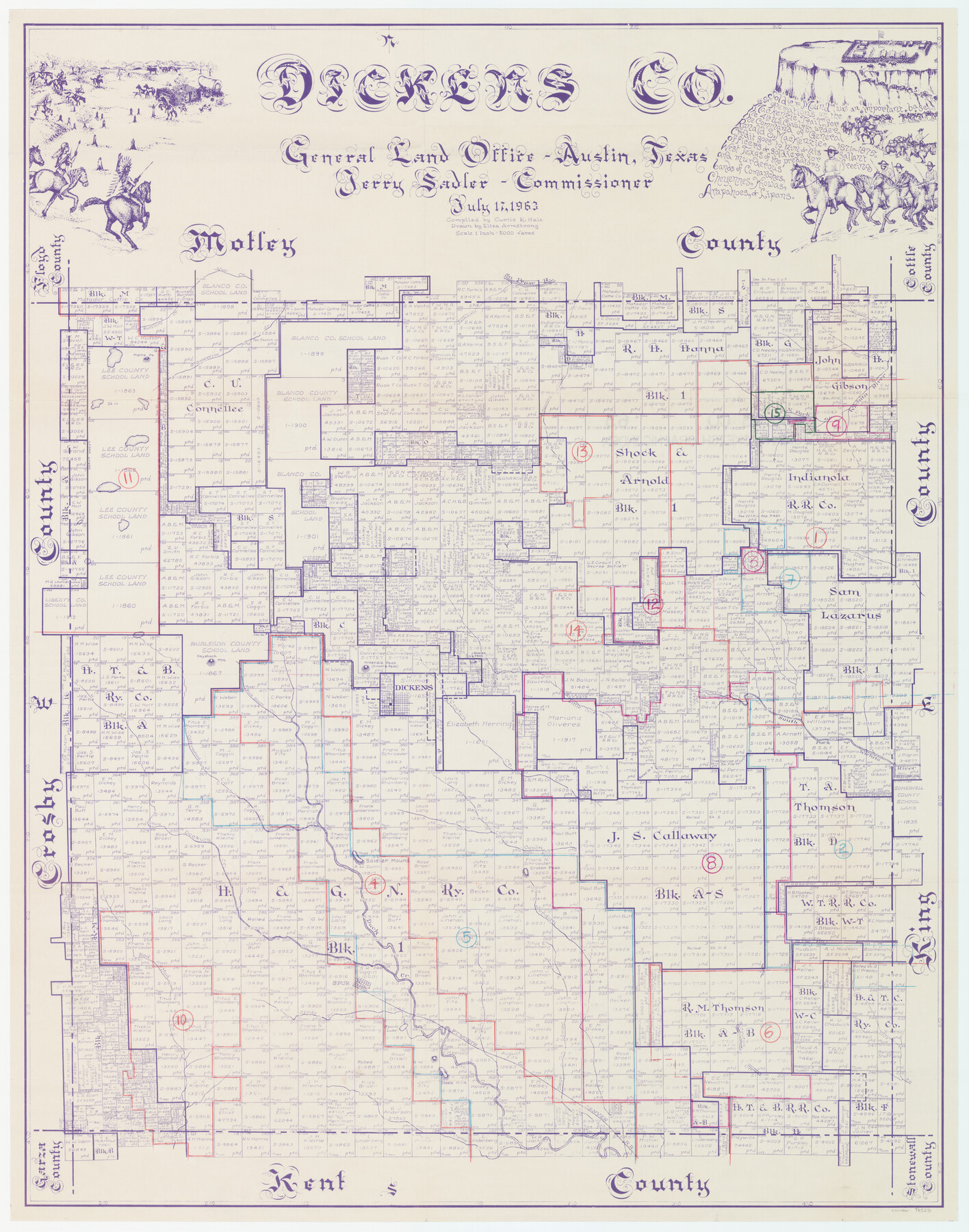
Dickens County Working Sketch Graphic Index
-
Map/Doc
76523
-
Collection
General Map Collection
-
Object Dates
7/17/1963 (Creation Date)
-
People and Organizations
Curtis R. Hale (Compiler)
Eltea Armstrong (Draftsman)
-
Counties
Dickens
-
Subjects
County Surveying Working Sketch
-
Height x Width
42.5 x 33.6 inches
108.0 x 85.3 cm
-
Scale
1" = 2000 varas
Part of: General Map Collection
Panola County Sketch File 14

Print $4.00
- Digital $50.00
Panola County Sketch File 14
1873
Size 12.2 x 5.2 inches
Map/Doc 33472
Crane County Working Sketch 28

Print $40.00
- Digital $50.00
Crane County Working Sketch 28
1972
Size 49.4 x 49.1 inches
Map/Doc 68305
Flight Mission No. BQY-4M, Frame 38, Harris County

Print $20.00
- Digital $50.00
Flight Mission No. BQY-4M, Frame 38, Harris County
1953
Size 18.6 x 22.4 inches
Map/Doc 85253
Crockett County Rolled Sketch 28

Print $20.00
- Digital $50.00
Crockett County Rolled Sketch 28
1884
Size 42.5 x 25.8 inches
Map/Doc 5587
Texas 1972 Official Highway Travel Map

Digital $50.00
Texas 1972 Official Highway Travel Map
Size 27.9 x 36.0 inches
Map/Doc 94313
Navarro County Sketch File 5

Print $6.00
- Digital $50.00
Navarro County Sketch File 5
1852
Size 5.5 x 8.1 inches
Map/Doc 32307
Hale County Boundary File 6

Print $40.00
- Digital $50.00
Hale County Boundary File 6
Size 37.9 x 6.8 inches
Map/Doc 54073
Denton County Working Sketch 28

Print $20.00
- Digital $50.00
Denton County Working Sketch 28
1995
Size 36.1 x 22.9 inches
Map/Doc 68633
Bandera County Boundary File 4a

Print $32.00
- Digital $50.00
Bandera County Boundary File 4a
Size 13.3 x 8.7 inches
Map/Doc 50276
Navigation Maps of Gulf Intracoastal Waterway, Port Arthur to Brownsville, Texas

Print $4.00
- Digital $50.00
Navigation Maps of Gulf Intracoastal Waterway, Port Arthur to Brownsville, Texas
1951
Size 16.7 x 21.5 inches
Map/Doc 65424
Flight Mission No. BQR-3K, Frame 83, Brazoria County

Print $20.00
- Digital $50.00
Flight Mission No. BQR-3K, Frame 83, Brazoria County
1952
Size 18.7 x 22.4 inches
Map/Doc 83975
Burnet County Working Sketch 13

Print $40.00
- Digital $50.00
Burnet County Working Sketch 13
1977
Size 40.5 x 49.2 inches
Map/Doc 67856
You may also like
Archer County Sketch File B

Print $18.00
- Digital $50.00
Archer County Sketch File B
1892
Size 14.2 x 8.8 inches
Map/Doc 13566
Bravo Deed, Instrument 24, Tract A and Tract B

Print $3.00
- Digital $50.00
Bravo Deed, Instrument 24, Tract A and Tract B
Size 10.6 x 13.2 inches
Map/Doc 91478
[Yates, just south of Runnels County School Land]
![91653, [Yates, just south of Runnels County School Land], Twichell Survey Records](https://historictexasmaps.com/wmedia_w700/maps/91653-1.tif.jpg)
Print $20.00
- Digital $50.00
[Yates, just south of Runnels County School Land]
1928
Size 17.7 x 22.7 inches
Map/Doc 91653
Duval County Working Sketch 14

Print $20.00
- Digital $50.00
Duval County Working Sketch 14
1938
Size 15.2 x 17.7 inches
Map/Doc 68727
Map of San Patricio District

Print $40.00
- Digital $50.00
Map of San Patricio District
1870
Size 43.8 x 51.4 inches
Map/Doc 1987

Gillespie County Rolled Sketch 7

Print $20.00
- Digital $50.00
Gillespie County Rolled Sketch 7
2008
Size 18.9 x 18.8 inches
Map/Doc 88818
Houston County Sketch File 5

Print $4.00
- Digital $50.00
Houston County Sketch File 5
1860
Size 8.5 x 12.7 inches
Map/Doc 26757
Liberty County Rolled Sketch E

Print $20.00
- Digital $50.00
Liberty County Rolled Sketch E
Size 20.8 x 31.0 inches
Map/Doc 9439
[Map of Oldham County]
![91456, [Map of Oldham County], Twichell Survey Records](https://historictexasmaps.com/wmedia_w700/maps/91456-1.tif.jpg)
Print $20.00
- Digital $50.00
[Map of Oldham County]
Size 28.4 x 20.5 inches
Map/Doc 91456
General Highway Map, Moore County, Texas

Print $20.00
General Highway Map, Moore County, Texas
1961
Size 18.1 x 24.5 inches
Map/Doc 79604
Wichita County

Print $20.00
- Digital $50.00
Wichita County
1924
Size 33.7 x 40.2 inches
Map/Doc 63123