Bexar County Sketch File 50
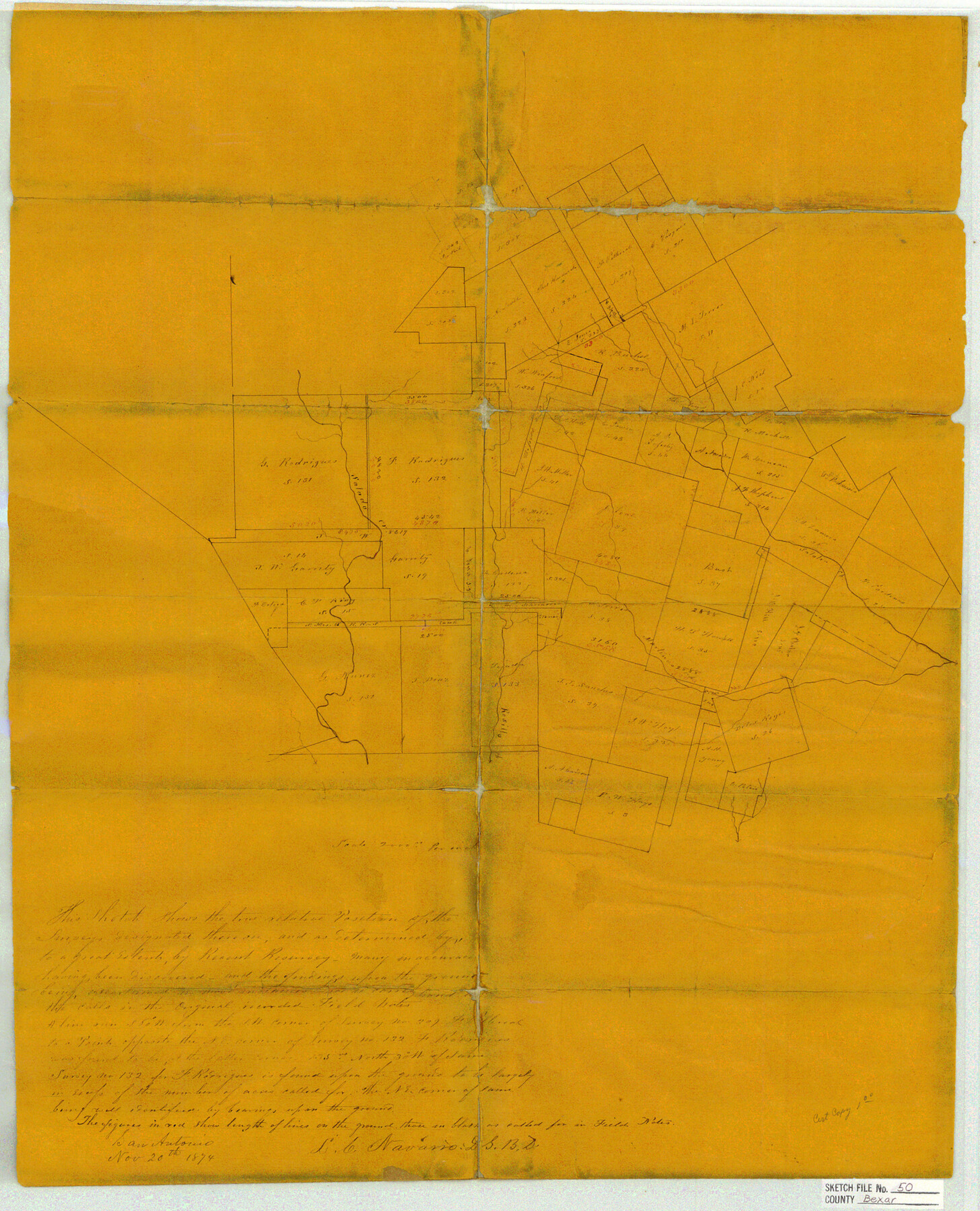
[Sketch of surveys near Salado, Martinez, and Salitrillo Creeks, east of San Antonio]
-
Map/Doc
10926
-
Collection
General Map Collection
-
Object Dates
1874/11/20 (Creation Date)
1874/11/28 (File Date)
-
People and Organizations
L.C. Navarro (Surveyor/Engineer)
-
Counties
Bexar
-
Subjects
Surveying Sketch File
-
Height x Width
22.5 x 18.2 inches
57.2 x 46.2 cm
-
Medium
paper, manuscript
-
Scale
1" = 2000 varas
-
Features
Salado Creek
Martinas [sic] Creek
Rosillo Creek
[Salatro Creek]
Part of: General Map Collection
Val Verde County Rolled Sketch 28

Print $20.00
- Digital $50.00
Val Verde County Rolled Sketch 28
Size 28.5 x 36.1 inches
Map/Doc 8110
Hays County Working Sketch 13

Print $20.00
- Digital $50.00
Hays County Working Sketch 13
1952
Size 24.2 x 35.0 inches
Map/Doc 66087

Young County Rolled Sketch 12

Print $20.00
- Digital $50.00
Young County Rolled Sketch 12
Size 24.2 x 17.9 inches
Map/Doc 8300
Ochiltree County Boundary File 1c

Print $2.00
- Digital $50.00
Ochiltree County Boundary File 1c
Size 10.6 x 8.1 inches
Map/Doc 57674
Matagorda County Sketch File 16

Print $4.00
- Digital $50.00
Matagorda County Sketch File 16
Size 8.4 x 10.3 inches
Map/Doc 30780
Val Verde County Sketch File 35A

Print $18.00
- Digital $50.00
Val Verde County Sketch File 35A
1936
Size 4.4 x 7.4 inches
Map/Doc 39253
Culberson County Sketch File 1c

Print $4.00
- Digital $50.00
Culberson County Sketch File 1c
1859
Size 7.4 x 8.0 inches
Map/Doc 20111
Cameron County

Print $20.00
- Digital $50.00
Cameron County
1976
Size 32.2 x 39.0 inches
Map/Doc 73098
Palo Pinto County

Print $20.00
- Digital $50.00
Palo Pinto County
1898
Size 46.3 x 39.1 inches
Map/Doc 66965
Schleicher County Working Sketch 17

Print $20.00
- Digital $50.00
Schleicher County Working Sketch 17
1946
Size 21.8 x 23.1 inches
Map/Doc 63819
Nacogdoches County Sketch File 7

Print $6.00
- Digital $50.00
Nacogdoches County Sketch File 7
1875
Size 10.4 x 15.0 inches
Map/Doc 32250
You may also like
Galveston County Rolled Sketch WF

Print $20.00
- Digital $50.00
Galveston County Rolled Sketch WF
Size 25.2 x 34.1 inches
Map/Doc 5991
Camp County Sketch File 1

Print $4.00
- Digital $50.00
Camp County Sketch File 1
Size 10.4 x 8.1 inches
Map/Doc 17333
Current Miscellaneous File 99

Print $32.00
- Digital $50.00
Current Miscellaneous File 99
1984
Size 11.2 x 8.7 inches
Map/Doc 74340
Northern Part of Laguna Madre

Print $20.00
- Digital $50.00
Northern Part of Laguna Madre
1949
Size 44.6 x 34.9 inches
Map/Doc 73524
General Highway Map, Potter County, Texas

Print $20.00
General Highway Map, Potter County, Texas
1961
Size 24.5 x 18.2 inches
Map/Doc 79631
Newton County Working Sketch 34

Print $20.00
- Digital $50.00
Newton County Working Sketch 34
1959
Size 27.0 x 32.6 inches
Map/Doc 71280
General Highway Map, Zapata County, Texas

Print $20.00
General Highway Map, Zapata County, Texas
1961
Size 18.2 x 24.8 inches
Map/Doc 79721
Leon County Working Sketch 29

Print $20.00
- Digital $50.00
Leon County Working Sketch 29
1971
Size 25.8 x 33.1 inches
Map/Doc 70428
Culberson County Working Sketch 69

Print $40.00
- Digital $50.00
Culberson County Working Sketch 69
1975
Size 49.4 x 32.2 inches
Map/Doc 68523
Runnels County Rolled Sketch 39

Print $20.00
- Digital $50.00
Runnels County Rolled Sketch 39
Size 34.3 x 31.6 inches
Map/Doc 7526
Working Sketch in Archer, Clay & Wichita Co's.

Print $40.00
- Digital $50.00
Working Sketch in Archer, Clay & Wichita Co's.
Size 68.5 x 43.5 inches
Map/Doc 89719
Andrews County Rolled Sketch 24

Print $20.00
- Digital $50.00
Andrews County Rolled Sketch 24
1946
Size 43.0 x 35.8 inches
Map/Doc 8397