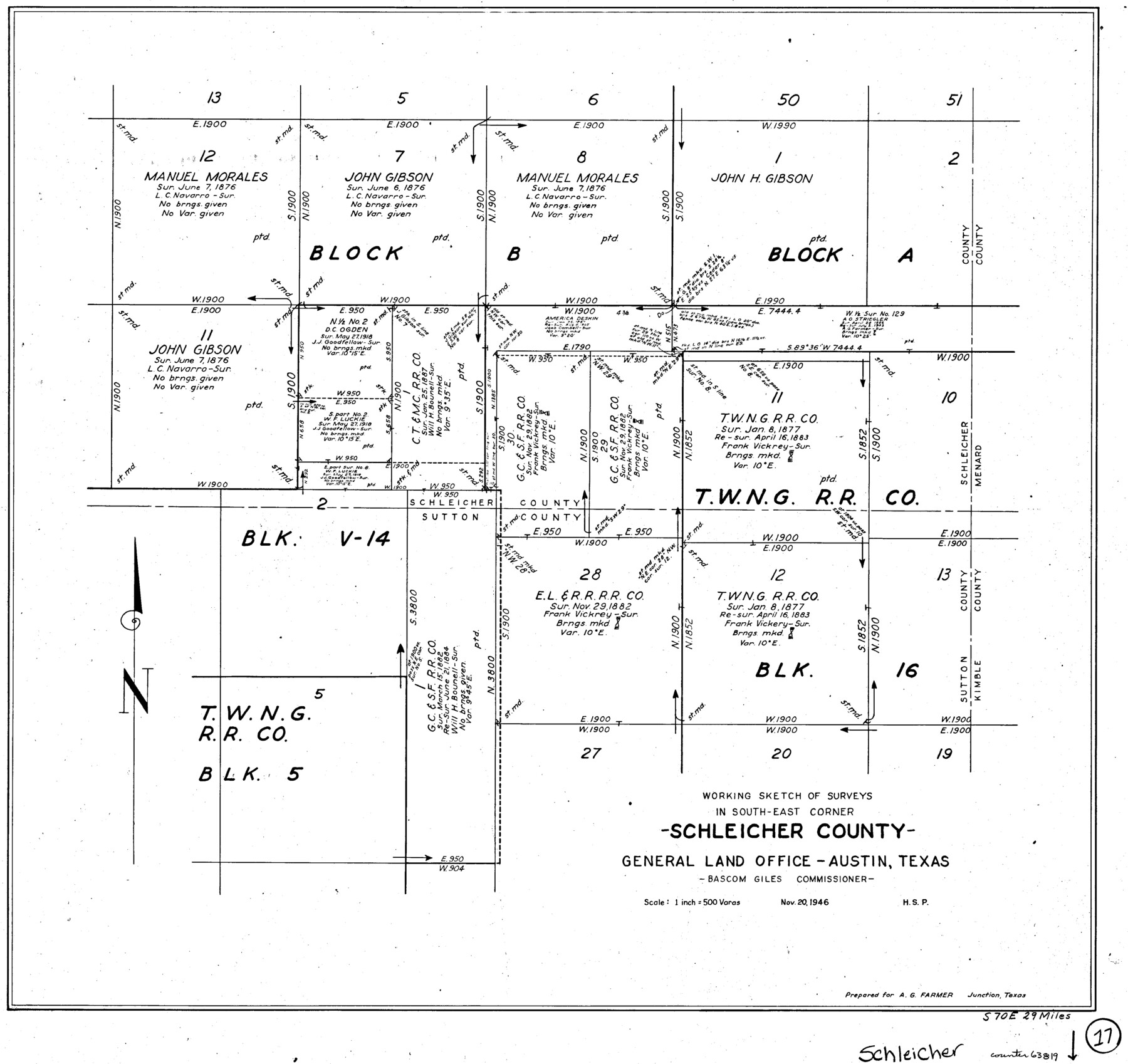
Schleicher County Working Sketch 17
-
Map/Doc
63819
-
Collection
General Map Collection
-
Object Dates
11/20/1946 (Creation Date)
-
Counties
Schleicher Sutton
-
Subjects
Surveying Working Sketch
-
Height x Width
21.8 x 23.1 inches
55.4 x 58.7 cm
-
Scale
1" = 500 varas
Part of: General Map Collection

Hudspeth County Working Sketch 37

Print $20.00
- Digital $50.00
Hudspeth County Working Sketch 37
1978
Size 32.8 x 46.8 inches
Map/Doc 66322
Section IX, Galveston Harbor and Bar

Print $20.00
- Digital $50.00
Section IX, Galveston Harbor and Bar
1850
Size 30.0 x 45.7 inches
Map/Doc 69855
Sterling County Working Sketch 6

Print $40.00
- Digital $50.00
Sterling County Working Sketch 6
1955
Size 38.1 x 121.6 inches
Map/Doc 63988
[Sketch for Mineral Application 31137 - Colorado River, W. A. Wagner]
![65634, [Sketch for Mineral Application 31137 - Colorado River, W. A. Wagner], General Map Collection](https://historictexasmaps.com/wmedia_w700/maps/65634.tif.jpg)
Print $40.00
- Digital $50.00
[Sketch for Mineral Application 31137 - Colorado River, W. A. Wagner]
1928
Size 39.6 x 126.2 inches
Map/Doc 65634
Brewster County Rolled Sketch 28

Print $20.00
- Digital $50.00
Brewster County Rolled Sketch 28
1910
Size 25.6 x 29.4 inches
Map/Doc 5215
Parker County Working Sketch 21

Print $20.00
- Digital $50.00
Parker County Working Sketch 21
2006
Map/Doc 83655
Burnet County Working Sketch 19

Print $20.00
- Digital $50.00
Burnet County Working Sketch 19
1982
Size 38.2 x 36.7 inches
Map/Doc 67862
Flight Mission No. BRA-6M, Frame 75, Jefferson County

Print $20.00
- Digital $50.00
Flight Mission No. BRA-6M, Frame 75, Jefferson County
1953
Size 18.8 x 22.5 inches
Map/Doc 85419
Map of the City of Beaumont, Texas

Print $20.00
- Digital $50.00
Map of the City of Beaumont, Texas
1897
Size 31.7 x 30.9 inches
Map/Doc 64146
University Lands as resurveyed by Frank F. Friend, Special Surveyor, San Angelo, Texas projected on a map of the State of Texas

Print $40.00
- Digital $50.00
University Lands as resurveyed by Frank F. Friend, Special Surveyor, San Angelo, Texas projected on a map of the State of Texas
1936
Size 31.0 x 55.8 inches
Map/Doc 2418
San Saba County

Print $20.00
- Digital $50.00
San Saba County
1918
Size 46.8 x 41.2 inches
Map/Doc 63022
You may also like
Refugio County Working Sketch 1

Print $20.00
- Digital $50.00
Refugio County Working Sketch 1
1917
Size 18.8 x 18.0 inches
Map/Doc 63510
Working Sketch in Kaufman County

Print $40.00
- Digital $50.00
Working Sketch in Kaufman County
1922
Size 36.5 x 52.2 inches
Map/Doc 89702
Culberson County Sketch File 10

Print $4.00
- Digital $50.00
Culberson County Sketch File 10
1911
Size 14.6 x 9.0 inches
Map/Doc 20144
Flight Mission No. DCL-7C, Frame 61, Kenedy County

Print $20.00
- Digital $50.00
Flight Mission No. DCL-7C, Frame 61, Kenedy County
1943
Size 15.4 x 15.2 inches
Map/Doc 86049
Controlled Mosaic by Jack Amman Photogrammetric Engineers, Inc - Sheet 23

Print $20.00
- Digital $50.00
Controlled Mosaic by Jack Amman Photogrammetric Engineers, Inc - Sheet 23
1954
Size 20.0 x 24.0 inches
Map/Doc 83474
Zapata County Sketch File 9

Print $40.00
- Digital $50.00
Zapata County Sketch File 9
1917
Size 31.8 x 49.4 inches
Map/Doc 10439
Travis County Working Sketch 15

Print $20.00
- Digital $50.00
Travis County Working Sketch 15
1939
Size 16.1 x 19.7 inches
Map/Doc 69399
San Jacinto County Working Sketch 41

Print $20.00
- Digital $50.00
San Jacinto County Working Sketch 41
1979
Size 44.6 x 35.2 inches
Map/Doc 63754
Flight Mission No. DQN-1K, Frame 155, Calhoun County

Print $20.00
- Digital $50.00
Flight Mission No. DQN-1K, Frame 155, Calhoun County
1953
Size 18.5 x 22.2 inches
Map/Doc 84214
Ward County Working Sketch 35

Print $20.00
- Digital $50.00
Ward County Working Sketch 35
1968
Size 46.4 x 43.0 inches
Map/Doc 72341
[Plat of Trinity River w/ Midstream Profile in Liberty County by US Government 1899]
![65335, [Plat of Trinity River w/ Midstream Profile in Liberty County by US Government 1899], General Map Collection](https://historictexasmaps.com/wmedia_w700/maps/65335.tif.jpg)
Print $20.00
- Digital $50.00
[Plat of Trinity River w/ Midstream Profile in Liberty County by US Government 1899]
1899
Size 11.5 x 18.3 inches
Map/Doc 65335
Spade Ranch Hockley County, Texas

Print $20.00
- Digital $50.00
Spade Ranch Hockley County, Texas
1948
Size 14.2 x 19.0 inches
Map/Doc 92225