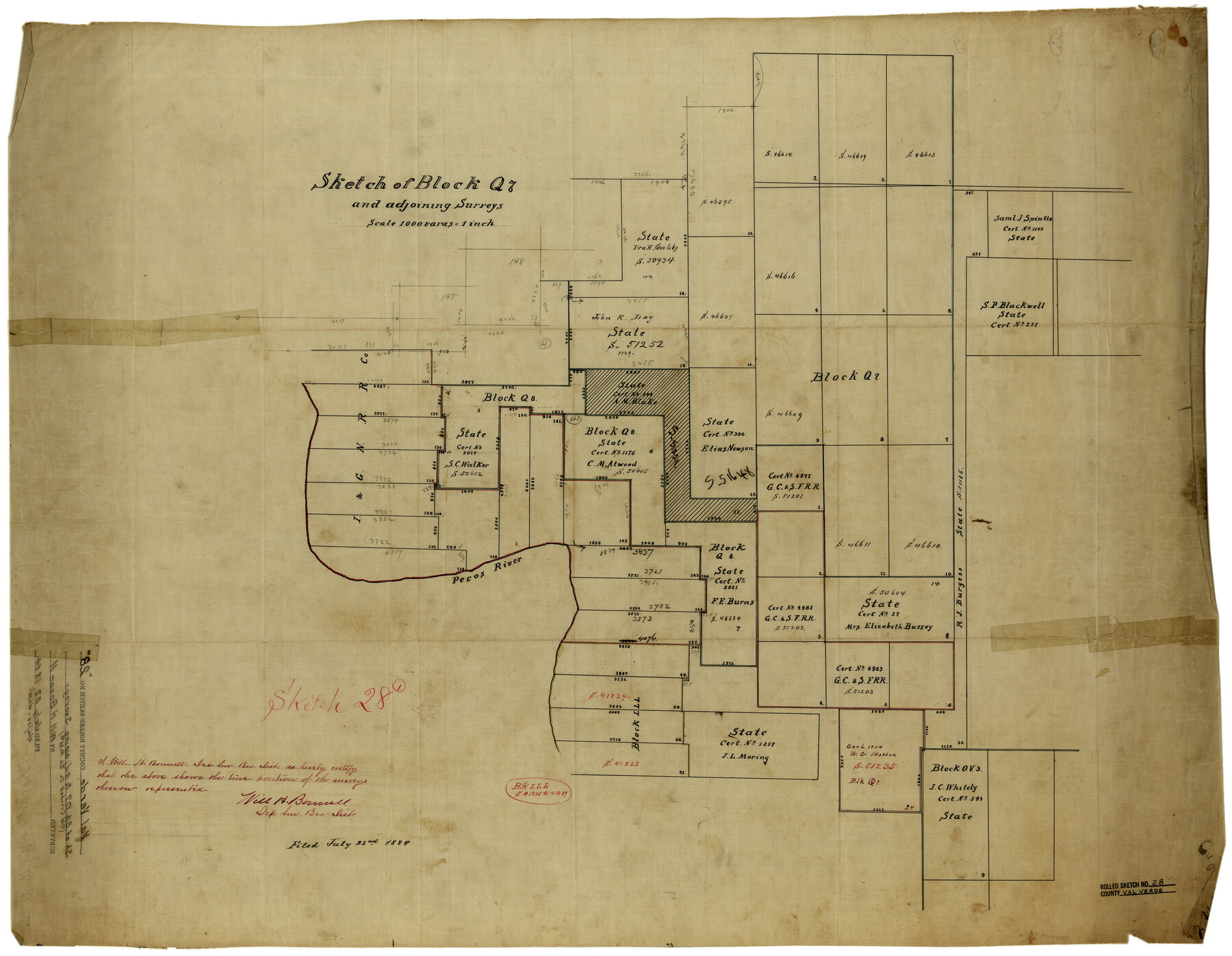
Val Verde County Rolled Sketch 28
Sketch of Block Q7 and adjoining surveys
- 
                          Map/Doc
8110
 - 
                            Collection
General Map Collection
 - 
                            Object Dates
7/22/1884 (File Date)
 - 
                            People and Organizations
Will H. Bonnell (Surveyor/Engineer)
 - 
                            Counties
Val Verde
 - 
                            Subjects
Surveying Rolled Sketch
 - 
                            Height x Width
28.5 x 36.1 inches
72.4 x 91.7 cm
 - 
                            Medium
linen, manuscript
 - 
                            Scale
1" = 1000 varas
 
Part of: General Map Collection
            Blanco County Sketch File 20


                                            Print $4.00                    
                                             -                         Digital $50.00                                    
                Blanco County Sketch File 20
1879
Size 8.7 x 6.9 inches
                                Map/Doc 14598
            
            Foard County Sketch File 15


                                            Print $8.00                    
                                             -                         Digital $50.00                                    
                Foard County Sketch File 15
1883
Size 13.0 x 8.5 inches
                                Map/Doc 22821
            
            Fractional Township No. 8 South Range No. 18 East of the Indian Meridian, Indian Territory


                                            Print $20.00                    
                                             -                         Digital $50.00                                    
                Fractional Township No. 8 South Range No. 18 East of the Indian Meridian, Indian Territory
1897
Size 19.2 x 24.3 inches
                                Map/Doc 75233
            
            Index sheet to accompany map of survey for connecting the inland waters along margin of the Gulf of Mexico from Donaldsonville in Louisiana to the Rio Grande River in Texas


                                            Print $20.00                    
                                             -                         Digital $50.00                                    
                Index sheet to accompany map of survey for connecting the inland waters along margin of the Gulf of Mexico from Donaldsonville in Louisiana to the Rio Grande River in Texas
1873
Size 18.2 x 28.1 inches
                                Map/Doc 72692
            
            Brooks County Working Sketch 3


                                            Print $20.00                    
                                             -                         Digital $50.00                                    
                Brooks County Working Sketch 3
Size 16.2 x 21.3 inches
                                Map/Doc 67787
            
            Webb County Sketch File 12d


                                            Print $20.00                    
                                             -                         Digital $50.00                                    
                Webb County Sketch File 12d
1886
Size 17.0 x 17.9 inches
                                Map/Doc 12629
            
            Henderson County


                                            Print $40.00                    
                                             -                         Digital $50.00                                    
                Henderson County
1922
Size 33.0 x 62.7 inches
                                Map/Doc 66861
            
            Flight Mission No. DQO-12K, Frame 43, Galveston County


                                            Print $20.00                    
                                             -                         Digital $50.00                                    
                Flight Mission No. DQO-12K, Frame 43, Galveston County
1952
Size 18.6 x 22.4 inches
                                Map/Doc 85233
            
            Collin County Rolled Sketch 1


                                            Print $20.00                    
                                             -                         Digital $50.00                                    
                Collin County Rolled Sketch 1
1953
Size 34.9 x 35.6 inches
                                Map/Doc 8635
            
            McMullen County Sketch File 4


                                            Print $4.00                    
                                             -                         Digital $50.00                                    
                McMullen County Sketch File 4
Size 7.9 x 10.1 inches
                                Map/Doc 31341
            
            Bosque County Sketch File 33


                                            Print $40.00                    
                                             -                         Digital $50.00                                    
                Bosque County Sketch File 33
Size 16.9 x 33.9 inches
                                Map/Doc 10939
            You may also like
            General Highway Map, Garza County, Texas


                                            Print $20.00                    
                                    
                General Highway Map, Garza County, Texas
1961
Size 18.2 x 24.6 inches
                                Map/Doc 79478
            
            Reagan County Working Sketch 27


                                            Print $20.00                    
                                             -                         Digital $50.00                                    
                Reagan County Working Sketch 27
1960
Size 33.0 x 42.5 inches
                                Map/Doc 71869
            
            General Highway Map, Waller County, Texas


                                            Print $20.00                    
                                    
                General Highway Map, Waller County, Texas
1939
Size 25.1 x 18.5 inches
                                Map/Doc 79270
            
            Chapman and McFarlin Production Co. Cogdell Ranch Kent County, Texas


                                            Print $2.00                    
                                             -                         Digital $50.00                                    
                Chapman and McFarlin Production Co. Cogdell Ranch Kent County, Texas
1952
Size 9.0 x 8.9 inches
                                Map/Doc 92190
            
            Edwards County Working Sketch 25


                                            Print $20.00                    
                                             -                         Digital $50.00                                    
                Edwards County Working Sketch 25
1942
Size 22.6 x 20.8 inches
                                Map/Doc 68901
            
            Archer County Working Sketch 18


                                            Print $20.00                    
                                             -                         Digital $50.00                                    
                Archer County Working Sketch 18
1957
Size 20.2 x 22.9 inches
                                Map/Doc 67159
            
            Knox County Sketch File 24


                                            Print $6.00                    
                                             -                         Digital $50.00                                    
                Knox County Sketch File 24
1945
Size 14.2 x 9.0 inches
                                Map/Doc 29254
            
            K&E Compensating Polar Planimeter


            K&E Compensating Polar Planimeter
1972
Size 2.1 x 11.6 inches
                                Map/Doc 97302
            
            Edwards County Rolled Sketch 32


                                            Print $20.00                    
                                             -                         Digital $50.00                                    
                Edwards County Rolled Sketch 32
1986
Size 36.7 x 24.3 inches
                                Map/Doc 8850
            
            Callahan County Rolled Sketch 1


                                            Print $20.00                    
                                             -                         Digital $50.00                                    
                Callahan County Rolled Sketch 1
1944
Size 26.9 x 26.3 inches
                                Map/Doc 5379
            
            Matagorda County Working Sketch 15


                                            Print $40.00                    
                                             -                         Digital $50.00                                    
                Matagorda County Working Sketch 15
1954
Size 49.3 x 44.5 inches
                                Map/Doc 70873
            
            Frio County Rolled Sketch 23


                                            Print $20.00                    
                                             -                         Digital $50.00                                    
                Frio County Rolled Sketch 23
1962
Size 39.4 x 40.8 inches
                                Map/Doc 8912