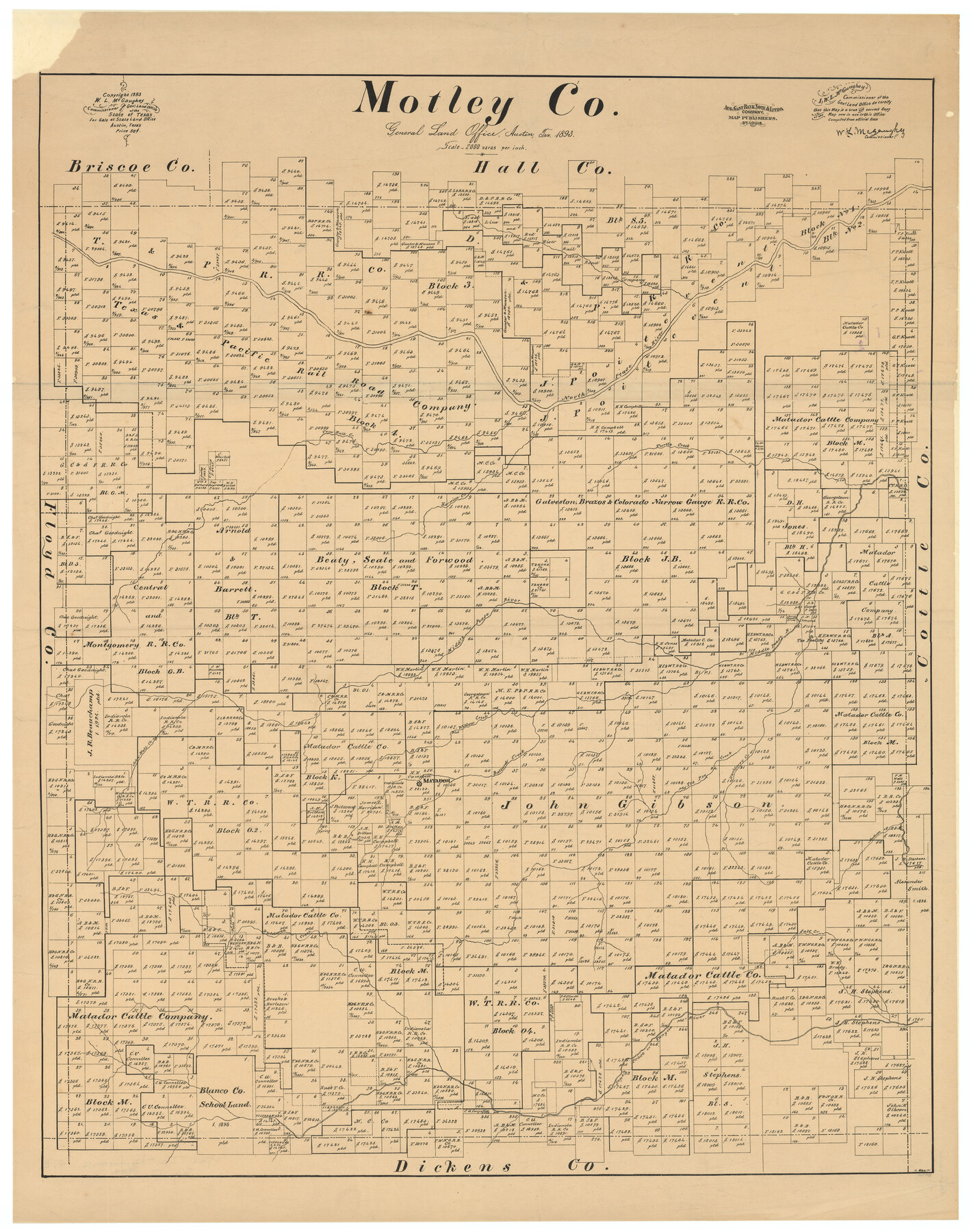
Motley Co.
-
Map/Doc
10798
-
Collection
General Map Collection
-
Object Dates
1893 (Creation Date)
-
People and Organizations
Texas General Land Office (Publisher)
W.L. McGaughey (GLO Commissioner)
F.G. Blau (Compiler)
F.G. Blau (Draftsman)
August Gast Bank Note & Lithograph Company (Lithographer)
-
Counties
Motley
-
Subjects
County
-
Height x Width
40.9 x 32.9 inches
103.9 x 83.6 cm
-
Comments
Copyrighted 1893.
Help Save Texas History - Adopt Me! -
Features
Hackberry Creek
T&P
Tongue River
Tangue [sic] River
Matador
Pease River
South Pease River
Salt Creek
Dutchman Creek
Autum [sic] A[rroyo]
Tee Pee City
Tee Pee Creek
Ballard Creek
Willow Creek
John Hall Creek
Middle Pease River
Hornica Creek
Tom Ball Creek
Turtle Creek
North Pease River
Part of: General Map Collection
Pecos County Working Sketch 33

Print $20.00
- Digital $50.00
Pecos County Working Sketch 33
1937
Size 26.7 x 35.6 inches
Map/Doc 71505
Webb County Sketch File 25

Print $20.00
- Digital $50.00
Webb County Sketch File 25
1936
Size 18.2 x 30.7 inches
Map/Doc 12639
Typus Orbis Terrarum

Print $20.00
- Digital $50.00
Typus Orbis Terrarum
1575
Size 15.2 x 20.8 inches
Map/Doc 96579
Somervell County

Print $20.00
- Digital $50.00
Somervell County
1941
Size 25.1 x 24.1 inches
Map/Doc 77424
[Rio Grande & Eagle Pass - Stockdale to Cuero]
![64047, [Rio Grande & Eagle Pass - Stockdale to Cuero], General Map Collection](https://historictexasmaps.com/wmedia_w700/maps/64047.tif.jpg)
Print $40.00
- Digital $50.00
[Rio Grande & Eagle Pass - Stockdale to Cuero]
Size 20.6 x 121.5 inches
Map/Doc 64047
Donley County Sketch File 10

Print $8.00
- Digital $50.00
Donley County Sketch File 10
1889
Size 9.6 x 6.1 inches
Map/Doc 21240
Young County Working Sketch 4

Print $20.00
- Digital $50.00
Young County Working Sketch 4
1919
Size 14.8 x 13.4 inches
Map/Doc 62027
Dimmit County Rolled Sketch 22A

Print $20.00
- Digital $50.00
Dimmit County Rolled Sketch 22A
2012
Size 23.2 x 34.0 inches
Map/Doc 93630
Jefferson County Rolled Sketch 20

Print $60.00
- Digital $50.00
Jefferson County Rolled Sketch 20
1935
Size 29.2 x 36.2 inches
Map/Doc 9285
Terrell County

Print $20.00
- Digital $50.00
Terrell County
1905
Size 41.6 x 30.9 inches
Map/Doc 63061
Map of Navarro County

Print $20.00
- Digital $50.00
Map of Navarro County
1858
Size 19.3 x 25.8 inches
Map/Doc 3912
Anderson County Sketch File 25

Print $40.00
- Digital $50.00
Anderson County Sketch File 25
1969
Size 40.9 x 21.9 inches
Map/Doc 10316
You may also like
Armstrong County Boundary File 2

Print $8.00
- Digital $50.00
Armstrong County Boundary File 2
Size 14.1 x 8.7 inches
Map/Doc 50137
[Connecting lines from west corner of S. K. & K. Block M6 to northwest corner section 1, J. G. & S. M. Blk. 2Z]
![90399, [Connecting lines from west corner of S. K. & K. Block M6 to northwest corner section 1, J. G. & S. M. Blk. 2Z], Twichell Survey Records](https://historictexasmaps.com/wmedia_w700/maps/90399-1.tif.jpg)
Print $20.00
- Digital $50.00
[Connecting lines from west corner of S. K. & K. Block M6 to northwest corner section 1, J. G. & S. M. Blk. 2Z]
Size 25.1 x 17.0 inches
Map/Doc 90399
Hardin County Rolled Sketch 13

Print $20.00
- Digital $50.00
Hardin County Rolled Sketch 13
1950
Size 29.8 x 27.4 inches
Map/Doc 9188
Fort Bend County Working Sketch 32

Print $20.00
- Digital $50.00
Fort Bend County Working Sketch 32
2000
Size 36.5 x 42.5 inches
Map/Doc 69238
Presidio County Rolled Sketch 131A

Print $20.00
- Digital $50.00
Presidio County Rolled Sketch 131A
Size 25.5 x 26.3 inches
Map/Doc 10712
Terrell County Working Sketch 19

Print $20.00
- Digital $50.00
Terrell County Working Sketch 19
1932
Size 18.6 x 25.6 inches
Map/Doc 69801
Nueces County Sketch File 6

Print $20.00
- Digital $50.00
Nueces County Sketch File 6
Size 15.0 x 22.2 inches
Map/Doc 42175
Zapata County Rolled Sketch 14

Print $20.00
- Digital $50.00
Zapata County Rolled Sketch 14
1925
Size 19.2 x 43.7 inches
Map/Doc 10168
Brewster County Sketch File N-23

Print $6.00
- Digital $50.00
Brewster County Sketch File N-23
1951
Size 14.4 x 9.0 inches
Map/Doc 15697
Brazoria County Sketch File 20

Print $40.00
- Digital $50.00
Brazoria County Sketch File 20
1853
Size 22.3 x 15.0 inches
Map/Doc 10953
Working Sketch in Bastrop County

Print $20.00
- Digital $50.00
Working Sketch in Bastrop County
1923
Size 18.4 x 14.6 inches
Map/Doc 90203
Coast Chart No. 211 - Padre I. and Laguna Madre, Lat. 27° 12' to Lat. 26° 33', Texas

Print $20.00
- Digital $50.00
Coast Chart No. 211 - Padre I. and Laguna Madre, Lat. 27° 12' to Lat. 26° 33', Texas
1890
Size 30.5 x 24.1 inches
Map/Doc 73502