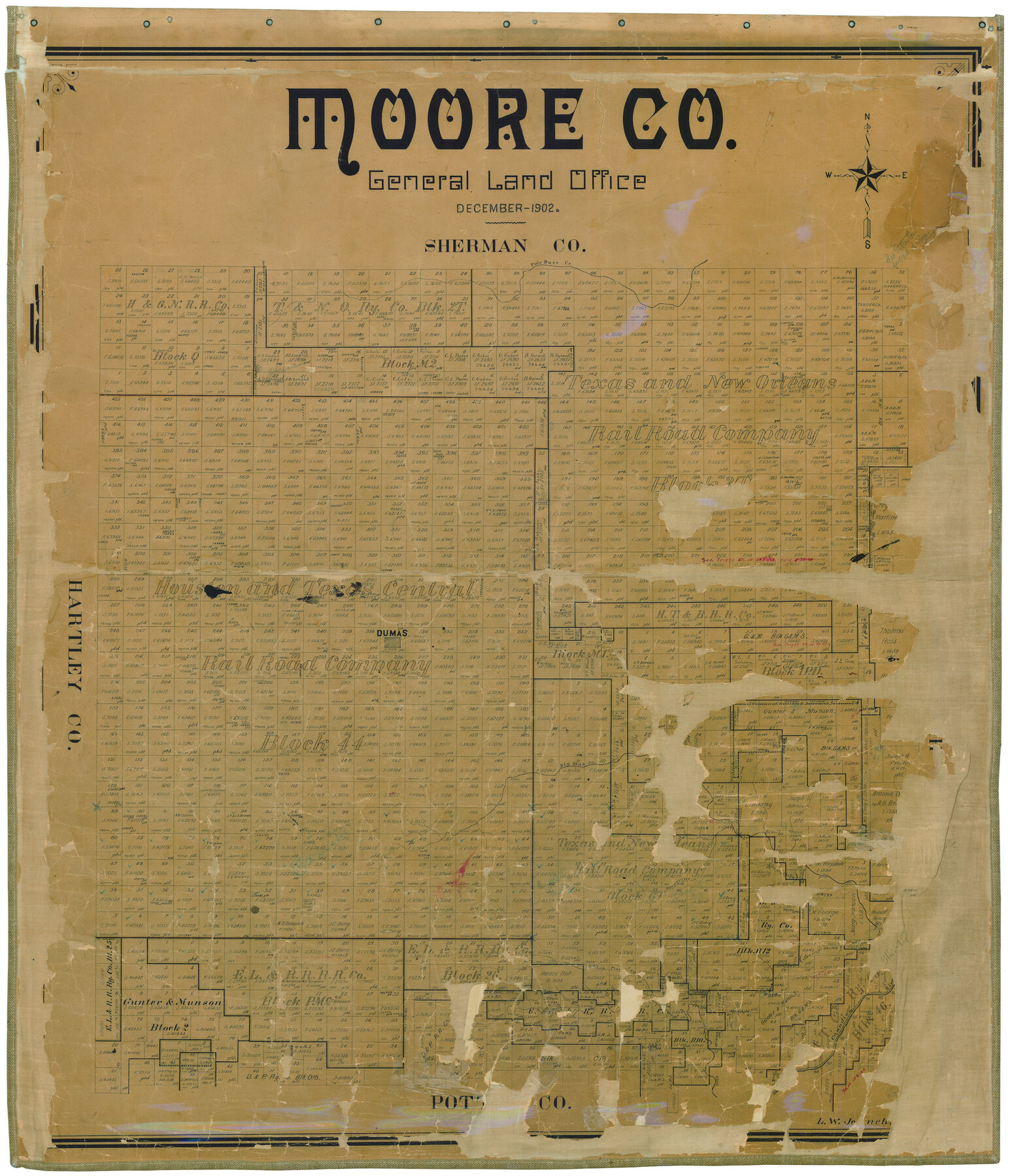
Moore Co.
-
Map/Doc
10795
-
Collection
General Map Collection
-
Object Dates
12/1902 (Creation Date)
-
People and Organizations
Texas General Land Office (Publisher)
L.W. Jelinek (Compiler)
L.W. Jelinek (Draftsman)
-
Counties
Moore
-
Subjects
County
-
Height x Width
43.4 x 37.1 inches
110.2 x 94.2 cm
-
Comments
Help Save Texas History - Adopt Me!
-
Features
Dumas
Paladora Creek
Big Blue Creek
Grapevine Creek
South Plum Creek
Canadian River
North Plum Creek
South Paladora Creek
Little Blue Creek
Tascosa Road
Dodge Road
Tascosa to Dodge Road
Part of: General Map Collection
Crockett County Sketch File 10 and 11

Print $8.00
- Digital $50.00
Crockett County Sketch File 10 and 11
Size 12.6 x 7.3 inches
Map/Doc 19661

Waller County Sketch File 1a

Print $20.00
- Digital $50.00
Waller County Sketch File 1a
Size 25.4 x 16.6 inches
Map/Doc 12598
Live Oak County Working Sketch 19

Print $20.00
- Digital $50.00
Live Oak County Working Sketch 19
1962
Size 27.4 x 34.5 inches
Map/Doc 70604
La Salle County Working Sketch 31

Print $20.00
- Digital $50.00
La Salle County Working Sketch 31
1955
Size 25.0 x 27.8 inches
Map/Doc 70332
Red River County Sketch File 28

Print $22.00
- Digital $50.00
Red River County Sketch File 28
1995
Size 11.3 x 8.9 inches
Map/Doc 35165
[Texas Gulf Coast from Rio Grande to Sabine Lake]
![72686, [Texas Gulf Coast from Rio Grande to Sabine Lake], General Map Collection](https://historictexasmaps.com/wmedia_w700/maps/72686.tif.jpg)
Print $20.00
- Digital $50.00
[Texas Gulf Coast from Rio Grande to Sabine Lake]
Size 28.0 x 18.3 inches
Map/Doc 72686
Williamson County Rolled Sketch 7

Print $40.00
- Digital $50.00
Williamson County Rolled Sketch 7
1924
Size 38.4 x 54.5 inches
Map/Doc 10146
Medina County Working Sketch 29

Print $20.00
- Digital $50.00
Medina County Working Sketch 29
Size 40.1 x 25.0 inches
Map/Doc 70944

Webb County Rolled Sketch 48

Print $20.00
- Digital $50.00
Webb County Rolled Sketch 48
1943
Size 20.1 x 37.3 inches
Map/Doc 8204

You may also like
Hudspeth County Rolled Sketch 77

Print $20.00
- Digital $50.00
Hudspeth County Rolled Sketch 77
Size 25.2 x 38.0 inches
Map/Doc 6265
Jones County Working Sketch 3

Print $20.00
- Digital $50.00
Jones County Working Sketch 3
1938
Size 28.7 x 25.4 inches
Map/Doc 66641
[Surveys possibly in Austin County]
![78356, [Surveys possibly in Austin County], General Map Collection](https://historictexasmaps.com/wmedia_w700/maps/78356.tif.jpg)
Print $3.00
- Digital $50.00
[Surveys possibly in Austin County]
Size 17.0 x 9.6 inches
Map/Doc 78356
Reagan County Rolled Sketch 9

Print $20.00
- Digital $50.00
Reagan County Rolled Sketch 9
1937
Size 29.7 x 30.9 inches
Map/Doc 7437
Flight Mission No. BRA-8M, Frame 115, Jefferson County

Print $20.00
- Digital $50.00
Flight Mission No. BRA-8M, Frame 115, Jefferson County
1953
Size 18.6 x 22.2 inches
Map/Doc 85611
Map of Georgia, Florida, Alabama, Mississippi and Tennessee engraved to illustrate Mitchell's new intermediate geography

Print $20.00
- Digital $50.00
Map of Georgia, Florida, Alabama, Mississippi and Tennessee engraved to illustrate Mitchell's new intermediate geography
1885
Size 12.2 x 9.0 inches
Map/Doc 93518
St. Louis Southwestern Railway of Texas

Print $40.00
- Digital $50.00
St. Louis Southwestern Railway of Texas
1905
Size 15.3 x 87.2 inches
Map/Doc 64445
Hays County Rolled Sketch 20A

Print $20.00
- Digital $50.00
Hays County Rolled Sketch 20A
Size 20.7 x 23.9 inches
Map/Doc 6177
Fractional Township No. 7 South Range No. 1 West of the Indian Meridian, Indian Territory

Print $4.00
- Digital $50.00
Fractional Township No. 7 South Range No. 1 West of the Indian Meridian, Indian Territory
1898
Size 18.1 x 22.4 inches
Map/Doc 75145

Presidio County Rolled Sketch 68

Print $20.00
- Digital $50.00
Presidio County Rolled Sketch 68
1927
Size 11.8 x 24.4 inches
Map/Doc 7358
[Block D3, Floyd County and Block GP, Motley County]
![90836, [Block D3, Floyd County and Block GP, Motley County], Twichell Survey Records](https://historictexasmaps.com/wmedia_w700/maps/90836-2.tif.jpg)
Print $20.00
- Digital $50.00
[Block D3, Floyd County and Block GP, Motley County]
Size 19.1 x 20.2 inches
Map/Doc 90836