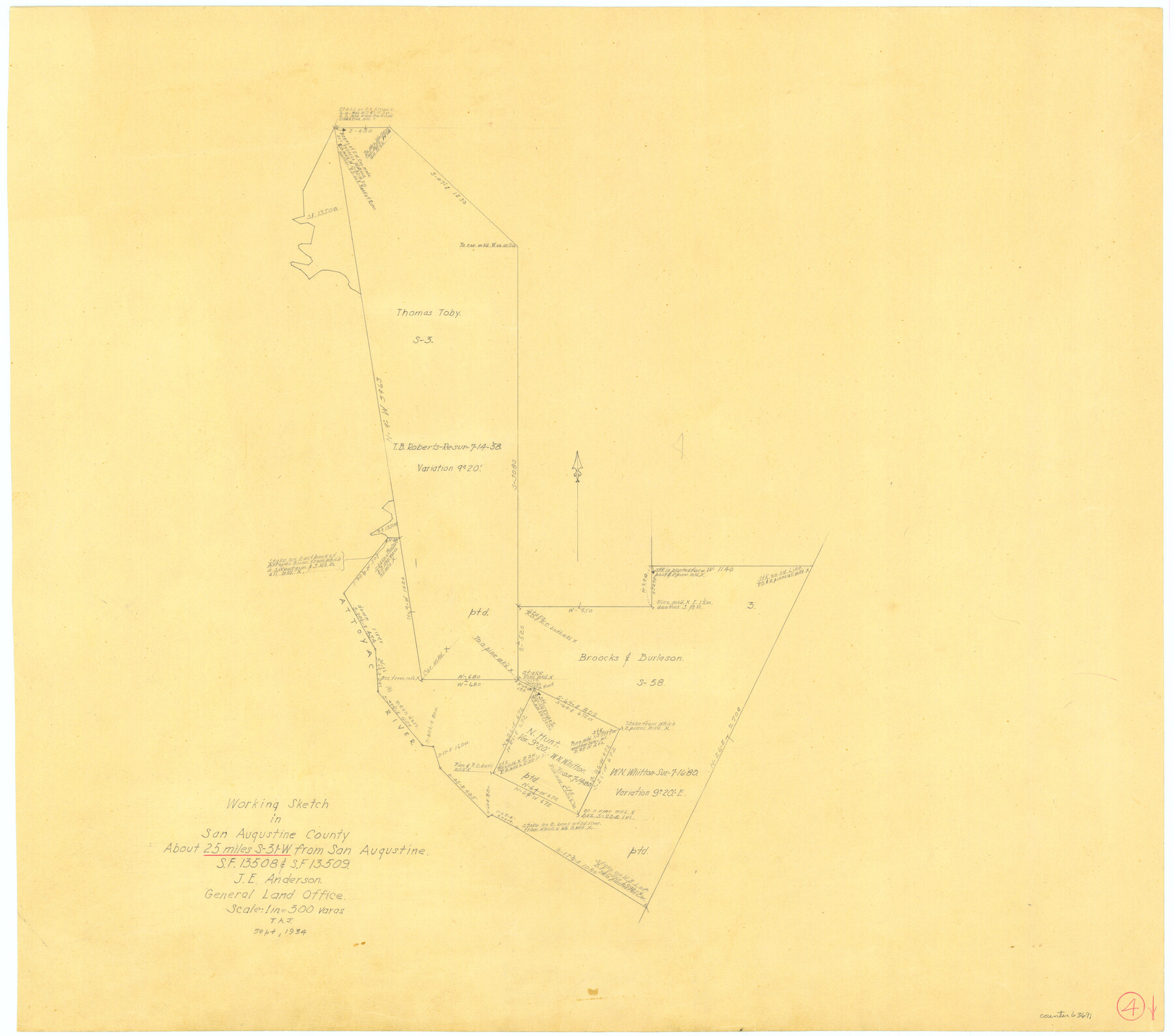
San Augustine County Working Sketch 4
-
Map/Doc
63691
-
Collection
General Map Collection
-
Object Dates
9/1934 (Creation Date)
-
Counties
San Augustine
-
Subjects
Surveying Working Sketch
-
Height x Width
24.4 x 27.7 inches
62.0 x 70.4 cm
-
Scale
1" = 300 varas
Part of: General Map Collection
Bexar County Working Sketch 21

Print $20.00
- Digital $50.00
Bexar County Working Sketch 21
1984
Size 21.3 x 28.8 inches
Map/Doc 67337
Real County Rolled Sketch 19

Print $20.00
- Digital $50.00
Real County Rolled Sketch 19
Size 42.0 x 41.7 inches
Map/Doc 9839
Presidio County Working Sketch 36

Print $20.00
- Digital $50.00
Presidio County Working Sketch 36
1947
Size 27.9 x 40.7 inches
Map/Doc 71713
South Part of Webb County

Print $40.00
- Digital $50.00
South Part of Webb County
1984
Size 41.2 x 61.5 inches
Map/Doc 77453
Erath County Sketch File 26

Print $6.00
- Digital $50.00
Erath County Sketch File 26
1896
Size 9.5 x 8.1 inches
Map/Doc 22306
Red River County Working Sketch 5

Print $20.00
- Digital $50.00
Red River County Working Sketch 5
1919
Size 14.7 x 12.8 inches
Map/Doc 71988
Flight Mission No. BQR-12K, Frame 49, Brazoria County

Print $20.00
- Digital $50.00
Flight Mission No. BQR-12K, Frame 49, Brazoria County
1952
Size 18.9 x 22.6 inches
Map/Doc 84064
Sutton County Rolled Sketch 59

Print $40.00
- Digital $50.00
Sutton County Rolled Sketch 59
1960
Size 86.1 x 42.5 inches
Map/Doc 9977
Right of Way and Track Map, International & Gt. Northern Ry. Operated by the International & Gt. Northern Ry. Co., Gulf Division

Print $40.00
- Digital $50.00
Right of Way and Track Map, International & Gt. Northern Ry. Operated by the International & Gt. Northern Ry. Co., Gulf Division
1917
Size 25.1 x 56.7 inches
Map/Doc 64246
Real County Working Sketch 52

Print $20.00
- Digital $50.00
Real County Working Sketch 52
1958
Size 36.2 x 38.6 inches
Map/Doc 71944
Scurry County Rolled Sketch 5

Print $40.00
- Digital $50.00
Scurry County Rolled Sketch 5
Size 48.4 x 41.1 inches
Map/Doc 9913

You may also like
Hopkins County Sketch File 5

Print $4.00
- Digital $50.00
Hopkins County Sketch File 5
Size 10.3 x 8.2 inches
Map/Doc 26687
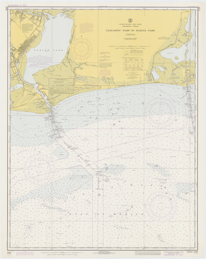
Calcasieu Pass to Sabine Pass
Print $20.00
- Digital $50.00
Calcasieu Pass to Sabine Pass
1973
Size 44.8 x 35.6 inches
Map/Doc 69812
Block 2, John W. Jarrotts Subdivision

Print $20.00
- Digital $50.00
Block 2, John W. Jarrotts Subdivision
1950
Size 15.1 x 13.7 inches
Map/Doc 92713

Close-up: USA - Arizona, New Mexico, Utah, Colorado

Close-up: USA - Arizona, New Mexico, Utah, Colorado
Size 35.0 x 22.9 inches
Map/Doc 96843
Marion County Sketch File 13

Print $24.00
- Digital $50.00
Marion County Sketch File 13
1912
Size 11.3 x 8.7 inches
Map/Doc 30583
Collingsworth County

Print $20.00
- Digital $50.00
Collingsworth County
1971
Size 40.7 x 34.2 inches
Map/Doc 77243
Flight Mission No. CRC-3R, Frame 28, Chambers County

Print $20.00
- Digital $50.00
Flight Mission No. CRC-3R, Frame 28, Chambers County
1956
Size 18.8 x 22.4 inches
Map/Doc 84803
Galveston County NRC Article 33.136 Sketch 48

Print $22.00
- Digital $50.00
Galveston County NRC Article 33.136 Sketch 48
2006
Size 24.4 x 36.7 inches
Map/Doc 88611
Karnes County Sketch File 6

Print $4.00
- Digital $50.00
Karnes County Sketch File 6
1858
Size 7.7 x 8.1 inches
Map/Doc 28557
Orange County Sketch File B

Print $20.00
- Digital $50.00
Orange County Sketch File B
1890
Size 17.6 x 26.0 inches
Map/Doc 12130
Caldwell County Working Sketch 9

Print $20.00
- Digital $50.00
Caldwell County Working Sketch 9
1968
Size 33.5 x 30.7 inches
Map/Doc 67839