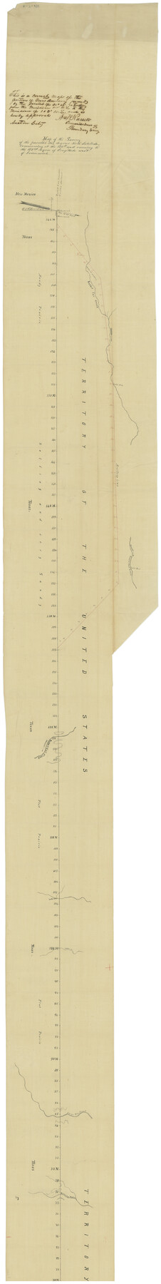
Map of the Survey of the Parallel 36 1/2 Degrees North Latitude, Commencing at the 100th and Running to the 103rd Degree of Longitude West of Greenwich
K-7-108
-
Map/Doc
73566
-
Collection
General Map Collection
-
Object Dates
1862 (Creation Date)
4/19/1862 (File Date)
-
People and Organizations
B. Timmons (Surveyor/Engineer)
-
Subjects
Texas Boundaries
-
Height x Width
115.6 x 14.9 inches
293.6 x 37.9 cm
-
Comments
Approved by Wm. W. Russell, Commissioner of Boundary Survey.
Part of: General Map Collection
Flight Mission No. BRE-1P, Frame 52, Nueces County

Print $20.00
- Digital $50.00
Flight Mission No. BRE-1P, Frame 52, Nueces County
1956
Size 18.4 x 22.0 inches
Map/Doc 86641
Schleicher County Working Sketch 27

Print $20.00
- Digital $50.00
Schleicher County Working Sketch 27
1974
Size 26.2 x 31.8 inches
Map/Doc 63829
Rusk County Sketch File 17a

Print $4.00
Rusk County Sketch File 17a
Size 8.4 x 7.8 inches
Map/Doc 35522
Comal County Working Sketch 12

Print $20.00
- Digital $50.00
Comal County Working Sketch 12
1987
Size 31.1 x 29.6 inches
Map/Doc 68178
Reeves County Working Sketch 49

Print $20.00
- Digital $50.00
Reeves County Working Sketch 49
1974
Size 46.4 x 32.4 inches
Map/Doc 63492
Flight Mission No. CUG-1P, Frame 159, Kleberg County

Print $20.00
- Digital $50.00
Flight Mission No. CUG-1P, Frame 159, Kleberg County
1956
Size 18.5 x 22.3 inches
Map/Doc 86166
Jefferson County Working Sketch 8

Print $20.00
- Digital $50.00
Jefferson County Working Sketch 8
1931
Size 34.9 x 18.2 inches
Map/Doc 66551
Louisiana and Texas Intracoastal Waterway Proposed Extension to Rio Grande Valley

Print $20.00
- Digital $50.00
Louisiana and Texas Intracoastal Waterway Proposed Extension to Rio Grande Valley
1941
Size 28.4 x 41.3 inches
Map/Doc 61890
Montgomery County

Print $20.00
- Digital $50.00
Montgomery County
1855
Size 26.5 x 28.3 inches
Map/Doc 3889
Kendall County Rolled Sketch 5

Print $20.00
- Digital $50.00
Kendall County Rolled Sketch 5
Size 23.4 x 19.3 inches
Map/Doc 6458
Kimble County Working Sketch 59

Print $20.00
- Digital $50.00
Kimble County Working Sketch 59
1963
Size 24.6 x 40.8 inches
Map/Doc 70127
Floyd County Sketch File 20

Print $4.00
- Digital $50.00
Floyd County Sketch File 20
1914
Size 14.5 x 8.9 inches
Map/Doc 22772
You may also like
Brewster County Working Sketch 116

Print $20.00
- Digital $50.00
Brewster County Working Sketch 116
1979
Size 25.3 x 38.6 inches
Map/Doc 67716
Upton County Rolled Sketch 48

Print $20.00
- Digital $50.00
Upton County Rolled Sketch 48
1958
Size 27.8 x 27.9 inches
Map/Doc 10694
Hudspeth County Rolled Sketch 60

Print $20.00
- Digital $50.00
Hudspeth County Rolled Sketch 60
1982
Size 43.4 x 44.4 inches
Map/Doc 9225
Map of Shackelford County, Texas

Print $20.00
- Digital $50.00
Map of Shackelford County, Texas
1879
Size 28.7 x 23.4 inches
Map/Doc 616
Erath County Working Sketch 41

Print $20.00
- Digital $50.00
Erath County Working Sketch 41
Size 25.5 x 29.0 inches
Map/Doc 69122
Gulf of Mexico

Print $20.00
- Digital $50.00
Gulf of Mexico
1961
Size 36.6 x 43.3 inches
Map/Doc 73551
Irion County Working Sketch 10

Print $20.00
- Digital $50.00
Irion County Working Sketch 10
1940
Size 29.6 x 43.5 inches
Map/Doc 66419
Flight Mission No. DCL-7C, Frame 22, Kenedy County

Print $20.00
- Digital $50.00
Flight Mission No. DCL-7C, Frame 22, Kenedy County
1943
Size 15.4 x 15.2 inches
Map/Doc 86014

Texas Coordinate File 3

Print $40.00
- Digital $50.00
Texas Coordinate File 3
Size 36.1 x 49.1 inches
Map/Doc 75306
9th Street & Ave. A. Galveston, Texas showing beginning of jetty right of way, and seawall extension track

Print $20.00
- Digital $50.00
9th Street & Ave. A. Galveston, Texas showing beginning of jetty right of way, and seawall extension track
1920
Size 21.3 x 33.6 inches
Map/Doc 73630
Flight Mission No. BQR-13K, Frame 20, Brazoria County

Print $20.00
- Digital $50.00
Flight Mission No. BQR-13K, Frame 20, Brazoria County
1952
Size 18.9 x 22.5 inches
Map/Doc 84068