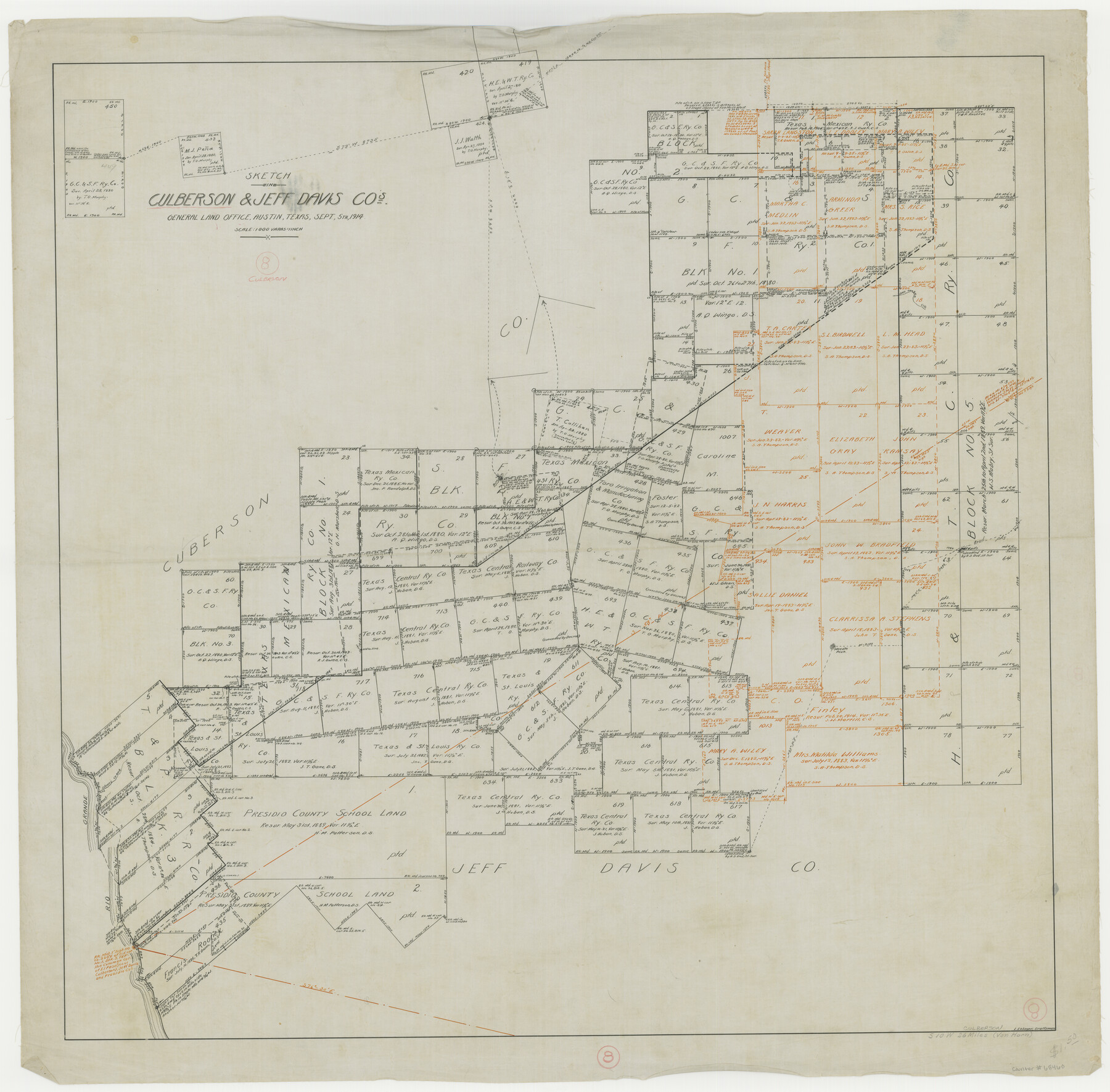
Culberson County Working Sketch 8
-
Map/Doc
68460
-
Collection
General Map Collection
-
Object Dates
9/5/1914 (Creation Date)
-
People and Organizations
L. Ehlinger (Draftsman)
-
Counties
Culberson Jeff Davis
-
Subjects
Surveying Working Sketch
-
Height x Width
35.4 x 36.0 inches
89.9 x 91.4 cm
-
Scale
1" = 1000 varas
Part of: General Map Collection
Presidio County Rolled Sketch 75

Print $20.00
- Digital $50.00
Presidio County Rolled Sketch 75
1938
Size 24.8 x 20.0 inches
Map/Doc 7363
Travis County Sketch File 8

Print $4.00
- Digital $50.00
Travis County Sketch File 8
Size 10.2 x 8.1 inches
Map/Doc 38288
Brewster County Sketch File FN-30

Print $4.00
- Digital $50.00
Brewster County Sketch File FN-30
1975
Size 12.0 x 8.7 inches
Map/Doc 15850
Hardin County Sketch File 6

Print $4.00
- Digital $50.00
Hardin County Sketch File 6
Size 8.0 x 12.7 inches
Map/Doc 25097
Uvalde County Working Sketch 19

Print $20.00
- Digital $50.00
Uvalde County Working Sketch 19
1948
Size 25.8 x 39.8 inches
Map/Doc 72089
Van Zandt County Working Sketch 12

Print $20.00
- Digital $50.00
Van Zandt County Working Sketch 12
1982
Size 21.5 x 20.7 inches
Map/Doc 72262
Fractional Township No. 9 South Range No. 23 East of the Indian Meridian, Indian Territory

Print $20.00
- Digital $50.00
Fractional Township No. 9 South Range No. 23 East of the Indian Meridian, Indian Territory
1898
Size 19.2 x 24.4 inches
Map/Doc 75240
Smith County Sketch File 13

Print $9.00
- Digital $50.00
Smith County Sketch File 13
1880
Size 16.7 x 8.4 inches
Map/Doc 36771
Erath County Sketch File 1

Print $4.00
- Digital $50.00
Erath County Sketch File 1
Size 3.9 x 8.1 inches
Map/Doc 22253
Falls County Sketch File 21

Print $4.00
- Digital $50.00
Falls County Sketch File 21
1878
Size 8.7 x 9.0 inches
Map/Doc 22394
Motley County Sketch File 7 (N)

Print $20.00
- Digital $50.00
Motley County Sketch File 7 (N)
1901
Size 16.0 x 19.8 inches
Map/Doc 42140
Starr County Working Sketch 30

Print $20.00
- Digital $50.00
Starr County Working Sketch 30
2015
Size 24.6 x 36.6 inches
Map/Doc 93750
You may also like
Kimble County Sketch File 40

Print $14.00
- Digital $50.00
Kimble County Sketch File 40
1888
Size 10.8 x 8.6 inches
Map/Doc 29003
J. W. Kendrick Land, Crosby County, Texas

Print $20.00
- Digital $50.00
J. W. Kendrick Land, Crosby County, Texas
Size 42.8 x 33.7 inches
Map/Doc 92603
Motley County

Print $20.00
- Digital $50.00
Motley County
1914
Size 47.0 x 37.7 inches
Map/Doc 66946
Panola County Working Sketch 40

Print $20.00
- Digital $50.00
Panola County Working Sketch 40
1995
Map/Doc 71449
Marion County

Print $20.00
- Digital $50.00
Marion County
1943
Size 30.3 x 47.9 inches
Map/Doc 95579
Kent County Working Sketch 5

Print $40.00
- Digital $50.00
Kent County Working Sketch 5
1950
Size 36.7 x 50.1 inches
Map/Doc 70012
Presidio County Working Sketch 23

Print $20.00
- Digital $50.00
Presidio County Working Sketch 23
1945
Size 35.7 x 23.3 inches
Map/Doc 71699
Harbor Pass and Bar at Brazos Santiago, Texas

Print $20.00
- Digital $50.00
Harbor Pass and Bar at Brazos Santiago, Texas
1871
Size 18.2 x 26.8 inches
Map/Doc 72983
Corpus Christi and Rio Grande Railway Company

Print $20.00
Corpus Christi and Rio Grande Railway Company
Size 14.6 x 24.0 inches
Map/Doc 95314
[Sketch showing surveys on the south side of the Canadian River, Blocks 4, M-3, M-19, M-20, 21-W, and Y-2]
![91740, [Sketch showing surveys on the south side of the Canadian River, Blocks 4, M-3, M-19, M-20, 21-W, and Y-2], Twichell Survey Records](https://historictexasmaps.com/wmedia_w700/maps/91740-1.tif.jpg)
Print $20.00
- Digital $50.00
[Sketch showing surveys on the south side of the Canadian River, Blocks 4, M-3, M-19, M-20, 21-W, and Y-2]
Size 43.4 x 25.1 inches
Map/Doc 91740
Map of Stephens County

Print $20.00
- Digital $50.00
Map of Stephens County
1897
Size 42.8 x 37.5 inches
Map/Doc 78394
Bell County Sketch File 11

Print $4.00
- Digital $50.00
Bell County Sketch File 11
1852
Size 9.9 x 7.8 inches
Map/Doc 14383