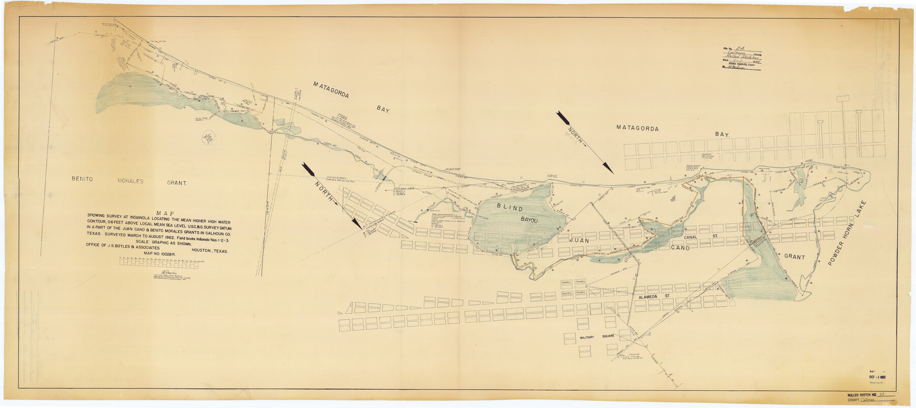
Calhoun County Rolled Sketch 24
Map showing survey at Indianola locating the Mean Higher High Water contour, 0.6 feet above local Mean Sea Level, U. S. C. & G. survey datum. In a part of the Juan Cano & Benito Morales grants in Calhoun Co., Texas
-
Map/Doc
5373
-
Collection
General Map Collection
-
Object Dates
1962 (Creation Date)
1968/1/1 (File Date)
-
People and Organizations
J.S. Boyles (Surveyor/Engineer)
-
Counties
Calhoun
-
Subjects
Surveying Rolled Sketch
-
Height x Width
26.0 x 58.3 inches
66.0 x 148.1 cm
-
Medium
blueprint/diazo
Part of: General Map Collection
Rusk County Sketch File X

Print $20.00
Rusk County Sketch File X
1844
Size 18.3 x 22.4 inches
Map/Doc 12279
Presidio County Rolled Sketch 129

Print $20.00
- Digital $50.00
Presidio County Rolled Sketch 129
1989
Size 27.0 x 46.0 inches
Map/Doc 7399
Gray County Sketch File 11

Print $40.00
- Digital $50.00
Gray County Sketch File 11
Size 15.0 x 13.5 inches
Map/Doc 24452
Roberts County

Print $20.00
- Digital $50.00
Roberts County
1932
Size 39.7 x 35.8 inches
Map/Doc 77408
Bee County Working Sketch 20

Print $20.00
- Digital $50.00
Bee County Working Sketch 20
1982
Size 23.6 x 21.3 inches
Map/Doc 67270
Travis County Sketch File 23

Print $4.00
- Digital $50.00
Travis County Sketch File 23
1875
Size 12.8 x 8.5 inches
Map/Doc 38330
Austin County Rolled Sketch 6

Print $20.00
- Digital $50.00
Austin County Rolled Sketch 6
1951
Size 25.5 x 34.0 inches
Map/Doc 5108
Newton County Working Sketch 2

Print $20.00
- Digital $50.00
Newton County Working Sketch 2
1905
Size 14.5 x 19.3 inches
Map/Doc 71248
[Surveys along the Colorado and Navidad Rivers]
![60, [Surveys along the Colorado and Navidad Rivers], General Map Collection](https://historictexasmaps.com/wmedia_w700/maps/60.tif.jpg)
Print $20.00
- Digital $50.00
[Surveys along the Colorado and Navidad Rivers]
1840
Size 28.6 x 22.5 inches
Map/Doc 60
Motley County Sketch File 17 (N)

Print $4.00
- Digital $50.00
Motley County Sketch File 17 (N)
1913
Size 8.7 x 7.8 inches
Map/Doc 32060
Mitchell County Working Sketch 1

Print $20.00
- Digital $50.00
Mitchell County Working Sketch 1
1905
Size 24.2 x 20.7 inches
Map/Doc 71058
Denton County Working Sketch 10

Print $20.00
- Digital $50.00
Denton County Working Sketch 10
1960
Size 30.2 x 25.0 inches
Map/Doc 68615
You may also like
Neches River, Blackburn Bridge Sheet

Print $4.00
- Digital $50.00
Neches River, Blackburn Bridge Sheet
1938
Size 27.6 x 20.5 inches
Map/Doc 65083
Leon County Sketch File 29

Print $8.00
- Digital $50.00
Leon County Sketch File 29
1951
Size 11.2 x 8.8 inches
Map/Doc 29825
Upton County Working Sketch 5

Print $20.00
- Digital $50.00
Upton County Working Sketch 5
1909
Size 15.9 x 27.1 inches
Map/Doc 69501
Foard County Sketch File 23

Print $32.00
- Digital $50.00
Foard County Sketch File 23
Size 11.3 x 9.0 inches
Map/Doc 22846
[B. S. & F. Blocks 1 and 6, A. B. & M. Block 2 and surrounding surveys and blocks]
![91785, [B. S. & F. Blocks 1 and 6, A. B. & M. Block 2 and surrounding surveys and blocks], Twichell Survey Records](https://historictexasmaps.com/wmedia_w700/maps/91785-1.tif.jpg)
Print $20.00
- Digital $50.00
[B. S. & F. Blocks 1 and 6, A. B. & M. Block 2 and surrounding surveys and blocks]
Size 22.6 x 33.8 inches
Map/Doc 91785
McMullen County Working Sketch 6

Print $20.00
- Digital $50.00
McMullen County Working Sketch 6
1926
Size 24.5 x 22.9 inches
Map/Doc 70707

The Mexican Department of Nacogdoches. On the Eve of Texas Independence, 1836

Print $20.00
The Mexican Department of Nacogdoches. On the Eve of Texas Independence, 1836
2020
Size 18.4 x 21.7 inches
Map/Doc 95974
Harris County Sketch File 79

Print $20.00
- Digital $50.00
Harris County Sketch File 79
1972
Size 28.9 x 33.2 inches
Map/Doc 10481
[West Part of Claude E. Halsell's Survey Section 6 Block A7]
![91063, [West Part of Claude E. Halsell's Survey Section 6 Block A7], Twichell Survey Records](https://historictexasmaps.com/wmedia_w700/maps/91063-1.tif.jpg)
Print $2.00
- Digital $50.00
[West Part of Claude E. Halsell's Survey Section 6 Block A7]
Size 9.2 x 14.7 inches
Map/Doc 91063
Galveston County Sketch File 59

Print $8.00
- Digital $50.00
Galveston County Sketch File 59
1977
Size 14.2 x 8.7 inches
Map/Doc 23607
The United States and the Relative Position of the Oregon and Texas

Print $20.00
- Digital $50.00
The United States and the Relative Position of the Oregon and Texas
1850
Size 16.8 x 23.1 inches
Map/Doc 93666