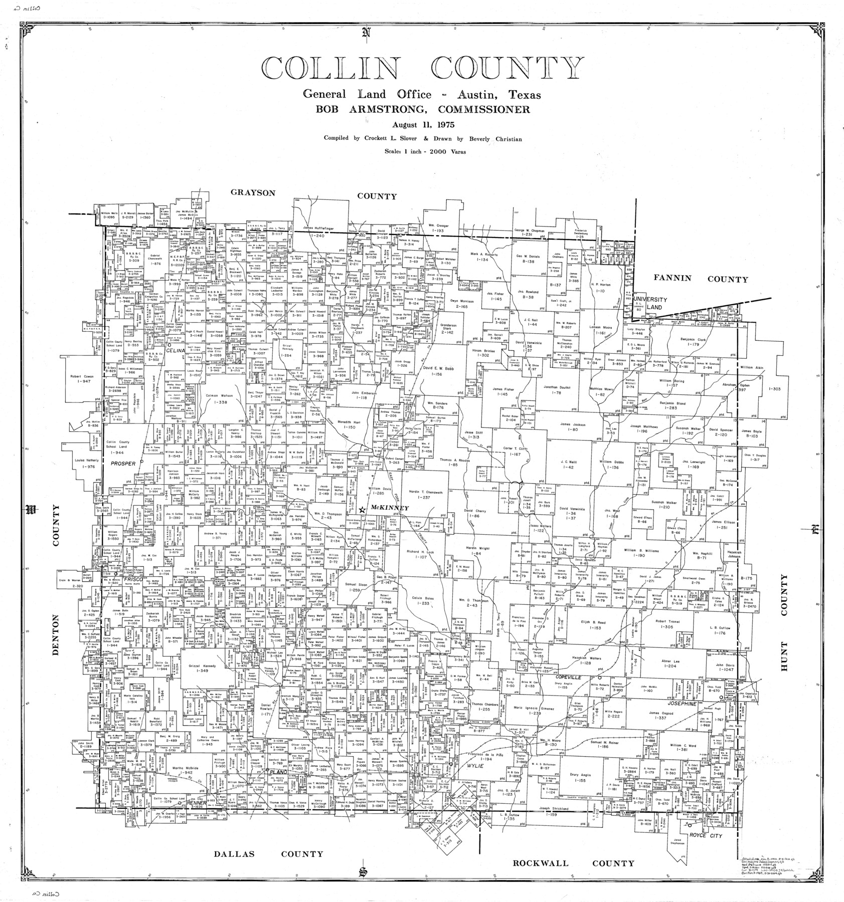
Collin County
-
Map/Doc
77242
-
Collection
General Map Collection
-
Object Dates
1975/8/11 (Creation Date)
-
People and Organizations
Crockett L. Slover (Compiler)
Beverly Christian (Draftsman)
-
Counties
Collin
-
Subjects
County
-
Height x Width
42.2 x 39.4 inches
107.2 x 100.1 cm
Part of: General Map Collection
Hardin County Working Sketch 6

Print $20.00
- Digital $50.00
Hardin County Working Sketch 6
1922
Size 16.2 x 28.4 inches
Map/Doc 63404
El Paso County Working Sketch 42

Print $20.00
- Digital $50.00
El Paso County Working Sketch 42
Size 24.6 x 26.6 inches
Map/Doc 69064
Hood County Working Sketch 16

Print $40.00
- Digital $50.00
Hood County Working Sketch 16
1987
Size 45.2 x 71.4 inches
Map/Doc 66210
Nautical Chart 152-SC - Galveston Bay, Texas

Print $20.00
- Digital $50.00
Nautical Chart 152-SC - Galveston Bay, Texas
1972
Size 15.4 x 18.5 inches
Map/Doc 75908
[Right of Way & Track Map, The Texas & Pacific Ry. Co. Main Line]
![64672, [Right of Way & Track Map, The Texas & Pacific Ry. Co. Main Line], General Map Collection](https://historictexasmaps.com/wmedia_w700/maps/64672.tif.jpg)
Print $20.00
- Digital $50.00
[Right of Way & Track Map, The Texas & Pacific Ry. Co. Main Line]
Size 11.0 x 18.4 inches
Map/Doc 64672
Stonewall County Rolled Sketch 21

Print $40.00
- Digital $50.00
Stonewall County Rolled Sketch 21
1953
Size 50.8 x 47.9 inches
Map/Doc 9960
Carta Agricola

Print $20.00
- Digital $50.00
Carta Agricola
1897
Size 26.0 x 34.3 inches
Map/Doc 96804
Galveston County NRC Article 33.136 Sketch 2

Print $46.00
- Digital $50.00
Galveston County NRC Article 33.136 Sketch 2
2000
Size 23.1 x 34.4 inches
Map/Doc 61565
Brewster County Rolled Sketch 123

Print $25.00
- Digital $50.00
Brewster County Rolled Sketch 123
Size 10.1 x 15.3 inches
Map/Doc 43129
Montgomery County Working Sketch 33

Print $20.00
- Digital $50.00
Montgomery County Working Sketch 33
1950
Size 28.8 x 28.2 inches
Map/Doc 71140
Harrison County Rolled Sketch 10

Print $20.00
- Digital $50.00
Harrison County Rolled Sketch 10
1956
Size 33.6 x 26.1 inches
Map/Doc 6153
Shackelford County Sketch File 6

Print $20.00
- Digital $50.00
Shackelford County Sketch File 6
Size 14.8 x 24.5 inches
Map/Doc 81981
You may also like
Blanco County Working Sketch 8

Print $20.00
- Digital $50.00
Blanco County Working Sketch 8
1925
Size 23.0 x 22.3 inches
Map/Doc 67368
Flight Mission No. CUG-1P, Frame 42, Kleberg County

Print $20.00
- Digital $50.00
Flight Mission No. CUG-1P, Frame 42, Kleberg County
1956
Size 18.9 x 22.5 inches
Map/Doc 86120
Ector County Working Sketch 14

Print $40.00
- Digital $50.00
Ector County Working Sketch 14
1955
Size 72.7 x 43.4 inches
Map/Doc 68857
Flight Mission No. BRA-7M, Frame 32, Jefferson County

Print $20.00
- Digital $50.00
Flight Mission No. BRA-7M, Frame 32, Jefferson County
1953
Size 18.7 x 22.4 inches
Map/Doc 85483
Origins of Exports and Destination of Imports at Houston during 1921

Print $20.00
- Digital $50.00
Origins of Exports and Destination of Imports at Houston during 1921
1921
Size 13.6 x 19.6 inches
Map/Doc 97170
Chambers County Boundary File 50a

Print $40.00
- Digital $50.00
Chambers County Boundary File 50a
Size 22.2 x 17.1 inches
Map/Doc 51270
General Highway Map, Crosby County, Texas

Print $20.00
- Digital $50.00
General Highway Map, Crosby County, Texas
1950
Size 25.5 x 18.8 inches
Map/Doc 92597
Somervell County Sketch File 6

Print $6.00
- Digital $50.00
Somervell County Sketch File 6
1939
Size 13.6 x 8.6 inches
Map/Doc 36847
Hardin County Sketch File 12

Print $4.00
- Digital $50.00
Hardin County Sketch File 12
Size 5.4 x 8.2 inches
Map/Doc 25116
Cooke County Sketch File 36

Print $4.00
- Digital $50.00
Cooke County Sketch File 36
1881
Size 7.8 x 8.4 inches
Map/Doc 19304
Kent County Working Sketch 8

Print $20.00
- Digital $50.00
Kent County Working Sketch 8
1952
Size 27.2 x 37.1 inches
Map/Doc 70015
Sutton County Working Sketch 54

Print $20.00
- Digital $50.00
Sutton County Working Sketch 54
1957
Size 28.0 x 38.4 inches
Map/Doc 62397