Upshur County Sketch File 19

Print $40.00
- Digital $50.00
Upshur County Sketch File 19
Size: 17.9 x 22.2 inches
12507
Hopkins County Sketch File 15

Print $4.00
- Digital $50.00
Hopkins County Sketch File 15
Size: 10.6 x 7.3 inches
26711
Wood County Sketch File 1

Print $4.00
- Digital $50.00
Wood County Sketch File 1
Size: 12.7 x 7.9 inches
40629
Wood County Boundary File 1

Print $4.00
- Digital $50.00
Wood County Boundary File 1
Size: 12.6 x 8.1 inches
60154
Wood County Boundary File 2

Print $8.00
- Digital $50.00
Wood County Boundary File 2
Size: 8.4 x 7.1 inches
60155
Wood County Boundary File 2a

Print $6.00
- Digital $50.00
Wood County Boundary File 2a
Size: 10.0 x 8.0 inches
60159
Wood County Boundary File 3

Print $10.00
- Digital $50.00
Wood County Boundary File 3
Size: 12.4 x 8.5 inches
60162
Wood County Boundary File 4

Print $6.00
- Digital $50.00
Wood County Boundary File 4
Size: 12.1 x 8.1 inches
60167
Wood County Boundary File 5

Print $20.00
- Digital $50.00
Wood County Boundary File 5
Size: 10.8 x 8.1 inches
60170
Wood County Boundary File 6

Print $32.00
- Digital $50.00
Wood County Boundary File 6
Size: 14.3 x 8.6 inches
60180
Wood County Boundary File 7

Print $34.00
- Digital $50.00
Wood County Boundary File 7
Size: 13.3 x 8.8 inches
60187
Wood County Boundary File 97

Print $2.00
- Digital $50.00
Wood County Boundary File 97
Size: 9.4 x 4.5 inches
60195
Wood County Working Sketch 17

Print $20.00
- Digital $50.00
Wood County Working Sketch 17
Size: 24.0 x 31.3 inches
62017
Map of the Houston and G. N. R.R. and lands adjacent, from Troupe to the Texas Pacific R.R.

Print $40.00
- Digital $50.00
Map of the Houston and G. N. R.R. and lands adjacent, from Troupe to the Texas Pacific R.R.
Size: 21.2 x 92.0 inches
64627
Sabine River, Watershed of the Sabine and Neches Rivers

Print $20.00
- Digital $50.00
Sabine River, Watershed of the Sabine and Neches Rivers
Size: 39.5 x 36.0 inches
65132
Wood County Rolled Sketch 10

Print $20.00
- Digital $50.00
Wood County Rolled Sketch 10
Size: 30.1 x 26.1 inches
76416

Wood County Rolled Sketch 7

Print $20.00
- Digital $50.00
Wood County Rolled Sketch 7
Size: 31.9 x 26.9 inches
8285
Wood County Rolled Sketch 9

Print $20.00
- Digital $50.00
Wood County Rolled Sketch 9
Size: 30.6 x 18.1 inches
8287
English Field Notes of the Spanish Archives - Books J.S.2, 3, and 4

English Field Notes of the Spanish Archives - Books J.S.2, 3, and 4
1835
96550
Wood County Sketch File 15

Print $5.00
- Digital $50.00
Wood County Sketch File 15
1835
Size: 11.0 x 16.3 inches
40694
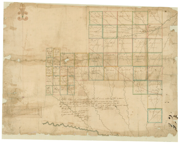
[Surveys in Hopkins and Wood Counties]
Print $20.00
- Digital $50.00
[Surveys in Hopkins and Wood Counties]
1838
Size: 24.7 x 31.7 inches
365
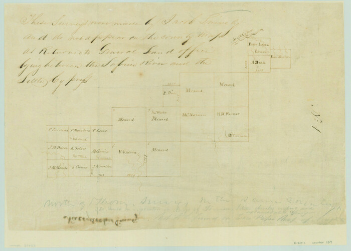
[Surveys between the Sabine River and Little Cypress Creek]
Print $3.00
- Digital $50.00
[Surveys between the Sabine River and Little Cypress Creek]
1840
Size: 9.3 x 13.0 inches
139
Kaufman County Sketch File 7

Print $5.00
- Digital $50.00
Kaufman County Sketch File 7
1847
Size: 8.3 x 10.1 inches
28636
Wood County Sketch File 7

Print $17.00
- Digital $50.00
Wood County Sketch File 7
1848
Size: 11.9 x 7.7 inches
40645
Wood County Sketch File 2

Print $4.00
- Digital $50.00
Wood County Sketch File 2
1848
Size: 8.3 x 6.4 inches
40631
Hunt County Sketch File 8

Print $4.00
- Digital $50.00
Hunt County Sketch File 8
1848
Size: 8.2 x 12.7 inches
27097
Wood County Sketch File 5

Print $4.00
- Digital $50.00
Wood County Sketch File 5
1848
Size: 10.7 x 9.0 inches
40637
Gregg County Sketch File 1D

Print $4.00
- Digital $50.00
Gregg County Sketch File 1D
1848
Size: 12.7 x 8.5 inches
24543
Wood County Sketch File 3

Print $4.00
- Digital $50.00
Wood County Sketch File 3
1848
Size: 10.1 x 8.1 inches
40633
Upshur County Sketch File 19
Print $40.00
- Digital $50.00
Upshur County Sketch File 19
-
Size
17.9 x 22.2 inches
-
Map/Doc
12507
Hopkins County Sketch File 15
Print $4.00
- Digital $50.00
Hopkins County Sketch File 15
-
Size
10.6 x 7.3 inches
-
Map/Doc
26711
Wood County Sketch File 1
Print $4.00
- Digital $50.00
Wood County Sketch File 1
-
Size
12.7 x 7.9 inches
-
Map/Doc
40629
Wood County Boundary File 1
Print $4.00
- Digital $50.00
Wood County Boundary File 1
-
Size
12.6 x 8.1 inches
-
Map/Doc
60154
Wood County Boundary File 2
Print $8.00
- Digital $50.00
Wood County Boundary File 2
-
Size
8.4 x 7.1 inches
-
Map/Doc
60155
Wood County Boundary File 2a
Print $6.00
- Digital $50.00
Wood County Boundary File 2a
-
Size
10.0 x 8.0 inches
-
Map/Doc
60159
Wood County Boundary File 3
Print $10.00
- Digital $50.00
Wood County Boundary File 3
-
Size
12.4 x 8.5 inches
-
Map/Doc
60162
Wood County Boundary File 4
Print $6.00
- Digital $50.00
Wood County Boundary File 4
-
Size
12.1 x 8.1 inches
-
Map/Doc
60167
Wood County Boundary File 5
Print $20.00
- Digital $50.00
Wood County Boundary File 5
-
Size
10.8 x 8.1 inches
-
Map/Doc
60170
Wood County Boundary File 6
Print $32.00
- Digital $50.00
Wood County Boundary File 6
-
Size
14.3 x 8.6 inches
-
Map/Doc
60180
Wood County Boundary File 7
Print $34.00
- Digital $50.00
Wood County Boundary File 7
-
Size
13.3 x 8.8 inches
-
Map/Doc
60187
Wood County Boundary File 97
Print $2.00
- Digital $50.00
Wood County Boundary File 97
-
Size
9.4 x 4.5 inches
-
Map/Doc
60195
Wood County Working Sketch 17
Print $20.00
- Digital $50.00
Wood County Working Sketch 17
-
Size
24.0 x 31.3 inches
-
Map/Doc
62017
Map of the Houston and G. N. R.R. and lands adjacent, from Troupe to the Texas Pacific R.R.
Print $40.00
- Digital $50.00
Map of the Houston and G. N. R.R. and lands adjacent, from Troupe to the Texas Pacific R.R.
-
Size
21.2 x 92.0 inches
-
Map/Doc
64627
Sabine River, Watershed of the Sabine and Neches Rivers
Print $20.00
- Digital $50.00
Sabine River, Watershed of the Sabine and Neches Rivers
-
Size
39.5 x 36.0 inches
-
Map/Doc
65132
Wood County Rolled Sketch 10
Print $20.00
- Digital $50.00
Wood County Rolled Sketch 10
-
Size
30.1 x 26.1 inches
-
Map/Doc
76416
Wood County Rolled Sketch 7
Print $20.00
- Digital $50.00
Wood County Rolled Sketch 7
-
Size
31.9 x 26.9 inches
-
Map/Doc
8285
Wood County Rolled Sketch 9
Print $20.00
- Digital $50.00
Wood County Rolled Sketch 9
-
Size
30.6 x 18.1 inches
-
Map/Doc
8287
English Field Notes of the Spanish Archives - Books J.S.2, 3, and 4
English Field Notes of the Spanish Archives - Books J.S.2, 3, and 4
1835
-
Map/Doc
96550
-
Creation Date
1835
Wood County Sketch File 15
Print $5.00
- Digital $50.00
Wood County Sketch File 15
1835
-
Size
11.0 x 16.3 inches
-
Map/Doc
40694
-
Creation Date
1835
[Surveys in Hopkins and Wood Counties]
Print $20.00
- Digital $50.00
[Surveys in Hopkins and Wood Counties]
1838
-
Size
24.7 x 31.7 inches
-
Map/Doc
365
-
Creation Date
1838
[Surveys between the Sabine River and Little Cypress Creek]
Print $3.00
- Digital $50.00
[Surveys between the Sabine River and Little Cypress Creek]
1840
-
Size
9.3 x 13.0 inches
-
Map/Doc
139
-
Creation Date
1840
Kaufman County Sketch File 7
Print $5.00
- Digital $50.00
Kaufman County Sketch File 7
1847
-
Size
8.3 x 10.1 inches
-
Map/Doc
28636
-
Creation Date
1847
Wood County Sketch File 7
Print $17.00
- Digital $50.00
Wood County Sketch File 7
1848
-
Size
11.9 x 7.7 inches
-
Map/Doc
40645
-
Creation Date
1848
Wood County Sketch File 2
Print $4.00
- Digital $50.00
Wood County Sketch File 2
1848
-
Size
8.3 x 6.4 inches
-
Map/Doc
40631
-
Creation Date
1848
Hunt County Sketch File 8
Print $4.00
- Digital $50.00
Hunt County Sketch File 8
1848
-
Size
8.2 x 12.7 inches
-
Map/Doc
27097
-
Creation Date
1848
Wood County Sketch File 5
Print $4.00
- Digital $50.00
Wood County Sketch File 5
1848
-
Size
10.7 x 9.0 inches
-
Map/Doc
40637
-
Creation Date
1848
Gregg County Sketch File 1D
Print $4.00
- Digital $50.00
Gregg County Sketch File 1D
1848
-
Size
12.7 x 8.5 inches
-
Map/Doc
24543
-
Creation Date
1848
Wood County Sketch File 3
Print $4.00
- Digital $50.00
Wood County Sketch File 3
1848
-
Size
10.1 x 8.1 inches
-
Map/Doc
40633
-
Creation Date
1848