Wood County Boundary File 4
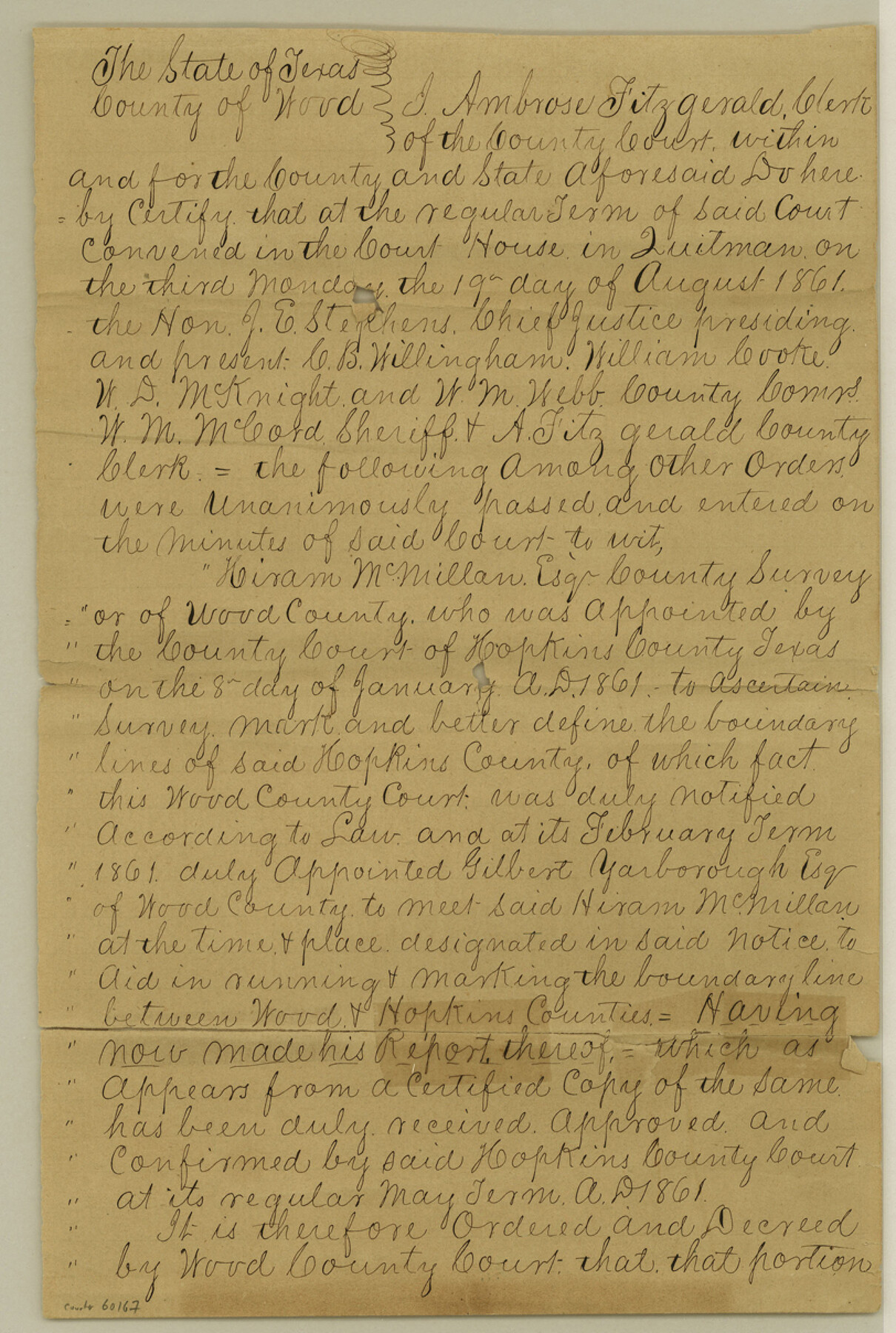
[Court Order regarding Wood-Hopkins Boundary line]
-
Map/Doc
60167
-
Collection
General Map Collection
-
Counties
Wood
-
Subjects
County Boundaries
-
Height x Width
12.1 x 8.1 inches
30.7 x 20.6 cm
Part of: General Map Collection

Flight Mission No. DAG-21K, Frame 38, Matagorda County

Print $20.00
- Digital $50.00
Flight Mission No. DAG-21K, Frame 38, Matagorda County
1952
Size 18.6 x 22.3 inches
Map/Doc 86405
Intracoastal Waterway - Gibbstown to Port Arthur

Print $20.00
- Digital $50.00
Intracoastal Waterway - Gibbstown to Port Arthur
1960
Size 26.9 x 38.9 inches
Map/Doc 69831
Ochiltree County Sketch File 7

Print $20.00
- Digital $50.00
Ochiltree County Sketch File 7
Size 14.5 x 26.1 inches
Map/Doc 42204
Scurry County Rolled Sketch 1

Print $40.00
- Digital $50.00
Scurry County Rolled Sketch 1
Size 70.5 x 44.9 inches
Map/Doc 9910
Schleicher County Sketch File 20

Print $20.00
- Digital $50.00
Schleicher County Sketch File 20
1936
Size 16.8 x 17.4 inches
Map/Doc 12301
Runnels County

Print $20.00
- Digital $50.00
Runnels County
1948
Size 46.5 x 36.4 inches
Map/Doc 77411
Duval County Sketch File 40b

Print $20.00
- Digital $50.00
Duval County Sketch File 40b
Size 28.0 x 31.4 inches
Map/Doc 11396
Foard County Sketch File XX

Print $40.00
- Digital $50.00
Foard County Sketch File XX
1884
Size 14.0 x 16.4 inches
Map/Doc 22802
El Paso County Rolled Sketch 43A

Print $20.00
- Digital $50.00
El Paso County Rolled Sketch 43A
Size 23.2 x 22.6 inches
Map/Doc 5829
Harris County Rolled Sketch 80B

Print $20.00
- Digital $50.00
Harris County Rolled Sketch 80B
Size 32.0 x 44.2 inches
Map/Doc 9137
Brooks County Rolled Sketch 7

Print $20.00
- Digital $50.00
Brooks County Rolled Sketch 7
1916
Size 28.5 x 30.4 inches
Map/Doc 5336
You may also like

Runnels County Sketch File E

Print $6.00
Runnels County Sketch File E
1895
Size 12.7 x 8.3 inches
Map/Doc 35481
Galveston County NRC Article 33.136 Sketch 93

Digital $50.00
Galveston County NRC Article 33.136 Sketch 93
2020
Map/Doc 97257
Navarro County

Print $40.00
- Digital $50.00
Navarro County
1924
Size 41.5 x 47.9 inches
Map/Doc 73249
Land fur Federmann und eine Heimath fur Heimathlose!

Land fur Federmann und eine Heimath fur Heimathlose!
1901
Map/Doc 96749
Map of South America designed to accompany Smith's Geography of Schools

Print $20.00
- Digital $50.00
Map of South America designed to accompany Smith's Geography of Schools
1850
Size 12.0 x 9.8 inches
Map/Doc 93891
Flight Mission No. BRE-2P, Frame 96, Nueces County

Print $20.00
- Digital $50.00
Flight Mission No. BRE-2P, Frame 96, Nueces County
1956
Size 18.4 x 22.3 inches
Map/Doc 86781
Freestone County Rolled Sketch 7

Print $20.00
- Digital $50.00
Freestone County Rolled Sketch 7
1918
Size 41.4 x 36.9 inches
Map/Doc 8895
South Sulphur River, Charleston Sheet

Print $20.00
- Digital $50.00
South Sulphur River, Charleston Sheet
1924
Size 16.6 x 18.0 inches
Map/Doc 78326
Cass County Sketch File 6

Print $4.00
- Digital $50.00
Cass County Sketch File 6
1852
Size 8.4 x 8.8 inches
Map/Doc 17406
[Surveys in the Bexar and San Patricio Districts along the Nueces and Frio Rivers]
![36, [Surveys in the Bexar and San Patricio Districts along the Nueces and Frio Rivers], General Map Collection](https://historictexasmaps.com/wmedia_w700/maps/36.tif.jpg)
Print $20.00
- Digital $50.00
[Surveys in the Bexar and San Patricio Districts along the Nueces and Frio Rivers]
1830
Size 21.5 x 27.3 inches
Map/Doc 36
Texas-Oklahoma Paris Quadrangle

Print $20.00
- Digital $50.00
Texas-Oklahoma Paris Quadrangle
Size 22.3 x 18.4 inches
Map/Doc 75107