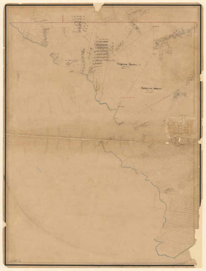
[Surveys along the Nueces River, San Patricio District]
Print $2.00
- Digital $50.00
[Surveys along the Nueces River, San Patricio District]
1842
Size: 10.3 x 7.9 inches
69738
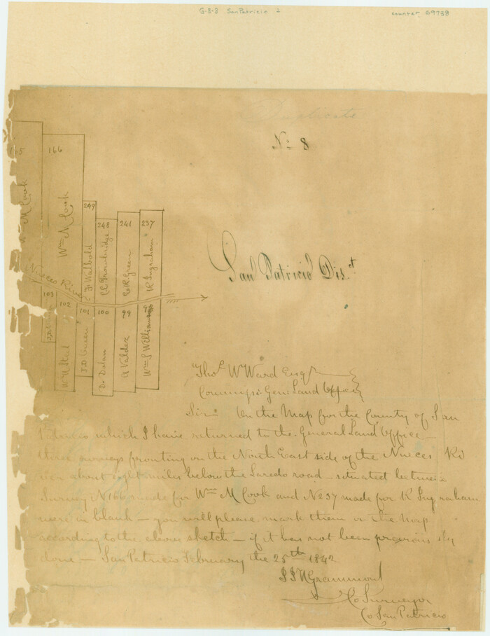
[Surveys along the Nueces River, San Patricio District]
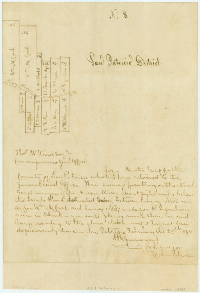
Print $2.00
- Digital $50.00
[Surveys along the Nueces River, San Patricio District]
1842
Size: 11.3 x 7.7 inches
69739
[Sketch with field note calls of the boundaries of Webb, Duval, Jim Wells,Nueces, Kleberg, Zapata, Jim Hogg, Brooks, Willacy, Starr, Hidalgo and Cameron Counties]
![1689, [Sketch with field note calls of the boundaries of Webb, Duval, Jim Wells,Nueces, Kleberg, Zapata, Jim Hogg, Brooks, Willacy, Starr, Hidalgo and Cameron Counties], General Map Collection](https://historictexasmaps.com/wmedia_w700/pdf_converted_jpg/qi_pdf_thumbnail_720.jpg)
Print $20.00
- Digital $50.00
[Sketch with field note calls of the boundaries of Webb, Duval, Jim Wells,Nueces, Kleberg, Zapata, Jim Hogg, Brooks, Willacy, Starr, Hidalgo and Cameron Counties]
1915
Size: 21.9 x 26.2 inches
1689
[Sketch showing voting precincts in Jim Hogg and Brooks Counties]
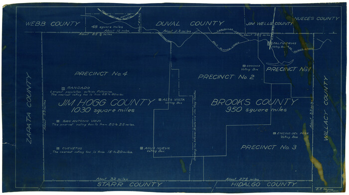
Print $20.00
- Digital $50.00
[Sketch showing voting precincts in Jim Hogg and Brooks Counties]
Size: 10.1 x 18.2 inches
4497
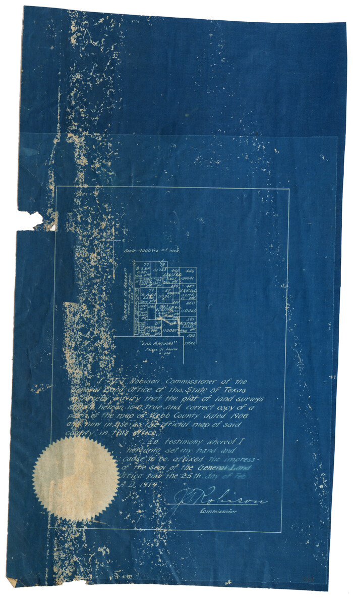
[Sketch of surveys north of "Las Animas" grant, Webb County]
Print $3.00
- Digital $50.00
[Sketch of surveys north of "Las Animas" grant, Webb County]
1908
Size: 16.9 x 10.7 inches
668
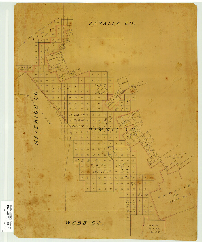
[Sketch Showing Surveys in Dimmit County, Texas]
Print $20.00
- Digital $50.00
[Sketch Showing Surveys in Dimmit County, Texas]
Size: 20.1 x 16.7 inches
5045
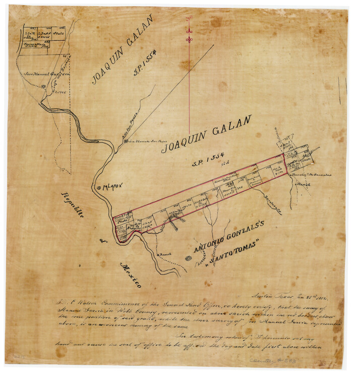
[Joaquin Galan Grant, Webb County]
Print $20.00
- Digital $50.00
[Joaquin Galan Grant, Webb County]
1882
Size: 12.4 x 11.7 inches
583
Zapata County Working Sketch 24

Print $20.00
- Digital $50.00
Zapata County Working Sketch 24
1992
Size: 28.2 x 23.9 inches
62075
Zapata County Sketch File 3

Print $6.00
- Digital $50.00
Zapata County Sketch File 3
1883
Size: 16.3 x 10.7 inches
40904
Zapata County Sketch File 2

Print $20.00
- Digital $50.00
Zapata County Sketch File 2
1875
Size: 24.3 x 32.8 inches
12718
Zapata County Sketch File 1

Print $20.00
- Digital $50.00
Zapata County Sketch File 1
1875
Size: 30.5 x 21.4 inches
12717
Webb County Working Sketch Graphic Index - south part

Print $40.00
- Digital $50.00
Webb County Working Sketch Graphic Index - south part
1984
Size: 43.4 x 62.9 inches
76735
Webb County Working Sketch Graphic Index - northwest part

Print $40.00
- Digital $50.00
Webb County Working Sketch Graphic Index - northwest part
1984
Size: 42.1 x 51.6 inches
76736
Webb County Working Sketch Graphic Index - northeast part

Print $20.00
- Digital $50.00
Webb County Working Sketch Graphic Index - northeast part
1986
Size: 35.7 x 47.1 inches
76734
Webb County Working Sketch 98

Print $40.00
- Digital $50.00
Webb County Working Sketch 98
2012
Size: 36.9 x 72.0 inches
93276
Webb County Working Sketch 97

Print $20.00
- Digital $50.00
Webb County Working Sketch 97
1994
Size: 27.1 x 30.6 inches
72464
Webb County Working Sketch 96

Print $20.00
- Digital $50.00
Webb County Working Sketch 96
1994
Size: 36.1 x 36.3 inches
72463
Webb County Working Sketch 95

Print $20.00
- Digital $50.00
Webb County Working Sketch 95
1991
Size: 16.6 x 42.2 inches
72462
Webb County Working Sketch 94

Print $20.00
- Digital $50.00
Webb County Working Sketch 94
1989
Size: 23.1 x 25.6 inches
72461
Webb County Working Sketch 93

Print $20.00
- Digital $50.00
Webb County Working Sketch 93
1989
Size: 15.7 x 20.1 inches
72460
Webb County Working Sketch 92

Print $20.00
- Digital $50.00
Webb County Working Sketch 92
1988
Size: 30.6 x 37.0 inches
72459
Webb County Working Sketch 91

Print $40.00
- Digital $50.00
Webb County Working Sketch 91
1982
Size: 37.1 x 49.7 inches
72458
Webb County Working Sketch 90

Print $20.00
- Digital $50.00
Webb County Working Sketch 90
1982
Size: 26.9 x 25.5 inches
72457
Webb County Working Sketch 9

Print $20.00
- Digital $50.00
Webb County Working Sketch 9
1911
Size: 17.2 x 30.8 inches
72374
Webb County Working Sketch 89

Print $20.00
- Digital $50.00
Webb County Working Sketch 89
1982
Size: 44.6 x 43.0 inches
72456
Webb County Working Sketch 88

Print $20.00
- Digital $50.00
Webb County Working Sketch 88
1982
Size: 24.2 x 19.7 inches
72455
Webb County Working Sketch 87

Print $20.00
- Digital $50.00
Webb County Working Sketch 87
1981
Size: 46.3 x 39.6 inches
72454
Webb County Working Sketch 86

Print $20.00
- Digital $50.00
Webb County Working Sketch 86
1981
Size: 44.3 x 37.0 inches
72453
Webb County Working Sketch 85

Print $20.00
- Digital $50.00
Webb County Working Sketch 85
1981
Size: 21.1 x 29.0 inches
72452
[Surveys along the Nueces River, San Patricio District]
Print $2.00
- Digital $50.00
[Surveys along the Nueces River, San Patricio District]
1842
-
Size
10.3 x 7.9 inches
-
Map/Doc
69738
-
Creation Date
1842
[Surveys along the Nueces River, San Patricio District]
Print $2.00
- Digital $50.00
[Surveys along the Nueces River, San Patricio District]
1842
-
Size
11.3 x 7.7 inches
-
Map/Doc
69739
-
Creation Date
1842
[Sketch with field note calls of the boundaries of Webb, Duval, Jim Wells,Nueces, Kleberg, Zapata, Jim Hogg, Brooks, Willacy, Starr, Hidalgo and Cameron Counties]
Print $20.00
- Digital $50.00
[Sketch with field note calls of the boundaries of Webb, Duval, Jim Wells,Nueces, Kleberg, Zapata, Jim Hogg, Brooks, Willacy, Starr, Hidalgo and Cameron Counties]
1915
-
Size
21.9 x 26.2 inches
-
Map/Doc
1689
-
Creation Date
1915
[Sketch showing voting precincts in Jim Hogg and Brooks Counties]
Print $20.00
- Digital $50.00
[Sketch showing voting precincts in Jim Hogg and Brooks Counties]
-
Size
10.1 x 18.2 inches
-
Map/Doc
4497
[Sketch of surveys north of "Las Animas" grant, Webb County]
Print $3.00
- Digital $50.00
[Sketch of surveys north of "Las Animas" grant, Webb County]
1908
-
Size
16.9 x 10.7 inches
-
Map/Doc
668
-
Creation Date
1908
[Sketch Showing Surveys in Dimmit County, Texas]
Print $20.00
- Digital $50.00
[Sketch Showing Surveys in Dimmit County, Texas]
-
Size
20.1 x 16.7 inches
-
Map/Doc
5045
[Joaquin Galan Grant, Webb County]
Print $20.00
- Digital $50.00
[Joaquin Galan Grant, Webb County]
1882
-
Size
12.4 x 11.7 inches
-
Map/Doc
583
-
Creation Date
1882
Zapata County Working Sketch 24
Print $20.00
- Digital $50.00
Zapata County Working Sketch 24
1992
-
Size
28.2 x 23.9 inches
-
Map/Doc
62075
-
Creation Date
1992
Zapata County Sketch File 3
Print $6.00
- Digital $50.00
Zapata County Sketch File 3
1883
-
Size
16.3 x 10.7 inches
-
Map/Doc
40904
-
Creation Date
1883
Zapata County Sketch File 2
Print $20.00
- Digital $50.00
Zapata County Sketch File 2
1875
-
Size
24.3 x 32.8 inches
-
Map/Doc
12718
-
Creation Date
1875
Zapata County Sketch File 1
Print $20.00
- Digital $50.00
Zapata County Sketch File 1
1875
-
Size
30.5 x 21.4 inches
-
Map/Doc
12717
-
Creation Date
1875
Webb County Working Sketch Graphic Index - south part
Print $40.00
- Digital $50.00
Webb County Working Sketch Graphic Index - south part
1984
-
Size
43.4 x 62.9 inches
-
Map/Doc
76735
-
Creation Date
1984
Webb County Working Sketch Graphic Index - northwest part
Print $40.00
- Digital $50.00
Webb County Working Sketch Graphic Index - northwest part
1984
-
Size
42.1 x 51.6 inches
-
Map/Doc
76736
-
Creation Date
1984
Webb County Working Sketch Graphic Index - northeast part
Print $20.00
- Digital $50.00
Webb County Working Sketch Graphic Index - northeast part
1986
-
Size
35.7 x 47.1 inches
-
Map/Doc
76734
-
Creation Date
1986
Webb County Working Sketch 98
Print $40.00
- Digital $50.00
Webb County Working Sketch 98
2012
-
Size
36.9 x 72.0 inches
-
Map/Doc
93276
-
Creation Date
2012
Webb County Working Sketch 97
Print $20.00
- Digital $50.00
Webb County Working Sketch 97
1994
-
Size
27.1 x 30.6 inches
-
Map/Doc
72464
-
Creation Date
1994
Webb County Working Sketch 96
Print $20.00
- Digital $50.00
Webb County Working Sketch 96
1994
-
Size
36.1 x 36.3 inches
-
Map/Doc
72463
-
Creation Date
1994
Webb County Working Sketch 95
Print $20.00
- Digital $50.00
Webb County Working Sketch 95
1991
-
Size
16.6 x 42.2 inches
-
Map/Doc
72462
-
Creation Date
1991
Webb County Working Sketch 94
Print $20.00
- Digital $50.00
Webb County Working Sketch 94
1989
-
Size
23.1 x 25.6 inches
-
Map/Doc
72461
-
Creation Date
1989
Webb County Working Sketch 93
Print $20.00
- Digital $50.00
Webb County Working Sketch 93
1989
-
Size
15.7 x 20.1 inches
-
Map/Doc
72460
-
Creation Date
1989
Webb County Working Sketch 92
Print $20.00
- Digital $50.00
Webb County Working Sketch 92
1988
-
Size
30.6 x 37.0 inches
-
Map/Doc
72459
-
Creation Date
1988
Webb County Working Sketch 91
Print $40.00
- Digital $50.00
Webb County Working Sketch 91
1982
-
Size
37.1 x 49.7 inches
-
Map/Doc
72458
-
Creation Date
1982
Webb County Working Sketch 90
Print $20.00
- Digital $50.00
Webb County Working Sketch 90
1982
-
Size
26.9 x 25.5 inches
-
Map/Doc
72457
-
Creation Date
1982
Webb County Working Sketch 9
Print $20.00
- Digital $50.00
Webb County Working Sketch 9
1911
-
Size
17.2 x 30.8 inches
-
Map/Doc
72374
-
Creation Date
1911
Webb County Working Sketch 89
Print $20.00
- Digital $50.00
Webb County Working Sketch 89
1982
-
Size
44.6 x 43.0 inches
-
Map/Doc
72456
-
Creation Date
1982
Webb County Working Sketch 88
Print $20.00
- Digital $50.00
Webb County Working Sketch 88
1982
-
Size
24.2 x 19.7 inches
-
Map/Doc
72455
-
Creation Date
1982
Webb County Working Sketch 87
Print $20.00
- Digital $50.00
Webb County Working Sketch 87
1981
-
Size
46.3 x 39.6 inches
-
Map/Doc
72454
-
Creation Date
1981
Webb County Working Sketch 86
Print $20.00
- Digital $50.00
Webb County Working Sketch 86
1981
-
Size
44.3 x 37.0 inches
-
Map/Doc
72453
-
Creation Date
1981
Webb County Working Sketch 85
Print $20.00
- Digital $50.00
Webb County Working Sketch 85
1981
-
Size
21.1 x 29.0 inches
-
Map/Doc
72452
-
Creation Date
1981