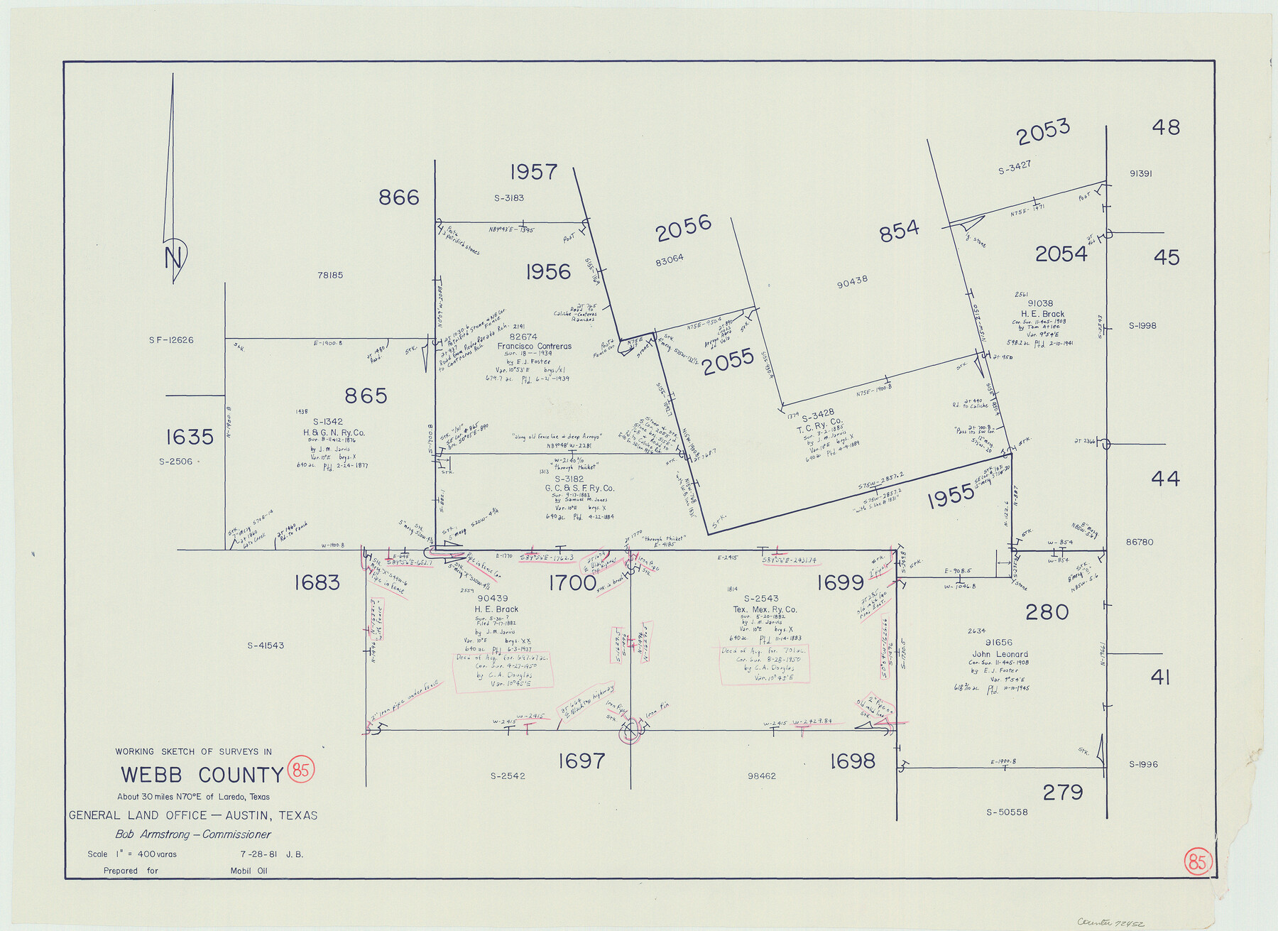
Webb County Working Sketch 85
-
Map/Doc
72452
-
Collection
General Map Collection
-
Object Dates
7/28/1981 (Creation Date)
-
People and Organizations
Jana Brod (Draftsman)
-
Counties
Webb
-
Subjects
Surveying Working Sketch
-
Height x Width
21.1 x 29.0 inches
53.6 x 73.7 cm
-
Scale
1" = 400 varas
Part of: General Map Collection
Sketch exhibiting the San Antonio River from the source to the fork of Goliad

Print $20.00
- Digital $50.00
Sketch exhibiting the San Antonio River from the source to the fork of Goliad
Size 27.5 x 16.6 inches
Map/Doc 73009

Baylor County Sketch File A4

Print $8.00
- Digital $50.00
Baylor County Sketch File A4
Size 14.0 x 8.7 inches
Map/Doc 14084
Wilbarger County Aerial Photograph Index Sheet 3

Print $20.00
- Digital $50.00
Wilbarger County Aerial Photograph Index Sheet 3
1950
Size 22.5 x 18.9 inches
Map/Doc 83752
Sutton County Working Sketch 37

Print $20.00
- Digital $50.00
Sutton County Working Sketch 37
1947
Size 31.0 x 41.4 inches
Map/Doc 62380
Montague County Working Sketch 19

Print $20.00
- Digital $50.00
Montague County Working Sketch 19
1952
Size 26.4 x 21.5 inches
Map/Doc 71085
Llano County Sketch File 9

Print $42.00
- Digital $50.00
Llano County Sketch File 9
Size 8.6 x 13.1 inches
Map/Doc 30369
Andrews County Boundary File 4

Print $40.00
- Digital $50.00
Andrews County Boundary File 4
Size 35.4 x 7.1 inches
Map/Doc 49721
Hudspeth County Sketch File 43

Print $10.00
- Digital $50.00
Hudspeth County Sketch File 43
1982
Size 14.3 x 8.9 inches
Map/Doc 27022
Lamb County Rolled Sketch 9

Print $20.00
- Digital $50.00
Lamb County Rolled Sketch 9
Size 44.7 x 27.9 inches
Map/Doc 9417
Flight Mission No. CUG-3P, Frame 43, Kleberg County

Print $20.00
- Digital $50.00
Flight Mission No. CUG-3P, Frame 43, Kleberg County
1956
Size 18.6 x 22.3 inches
Map/Doc 86248
Railroad Track Map, H&TCRRCo., Falls County, Texas

Print $4.00
- Digital $50.00
Railroad Track Map, H&TCRRCo., Falls County, Texas
1918
Size 11.6 x 18.6 inches
Map/Doc 62834
You may also like
Brewster County Rolled Sketch 144

Print $40.00
- Digital $50.00
Brewster County Rolled Sketch 144
Size 51.7 x 48.3 inches
Map/Doc 8526
Uvalde County Working Sketch 13

Print $20.00
- Digital $50.00
Uvalde County Working Sketch 13
1943
Size 27.9 x 21.6 inches
Map/Doc 72083


Map of Midland County

Print $20.00
- Digital $50.00
Map of Midland County
1901
Size 43.9 x 38.3 inches
Map/Doc 7825
Haskell County Working Sketch 2

Print $3.00
- Digital $50.00
Haskell County Working Sketch 2
1914
Size 14.9 x 10.1 inches
Map/Doc 66060
Crockett County Rolled Sketch CRV

Print $40.00
- Digital $50.00
Crockett County Rolled Sketch CRV
1925
Size 35.8 x 52.3 inches
Map/Doc 8693
Rockwall County Sketch File 9

Print $20.00
Rockwall County Sketch File 9
Size 31.1 x 39.7 inches
Map/Doc 10590
Map of Orange County

Print $20.00
- Digital $50.00
Map of Orange County
1895
Size 15.5 x 16.2 inches
Map/Doc 3932
Duval County Working Sketch 33

Print $20.00
- Digital $50.00
Duval County Working Sketch 33
1951
Size 21.9 x 23.3 inches
Map/Doc 68757

Township 7 South Range 13 West, South Western District, Louisiana

Print $20.00
- Digital $50.00
Township 7 South Range 13 West, South Western District, Louisiana
1879
Size 19.7 x 24.7 inches
Map/Doc 65887