[Tom Green County]
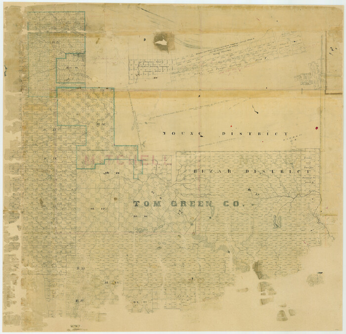
Print $20.00
- Digital $50.00
[Tom Green County]
1888
Size: 33.2 x 34.4 inches
16901
[Southern Pacific Rail Road Co. Blocks 15 and 16 in Mitchell, Sterling and Coke Counties]
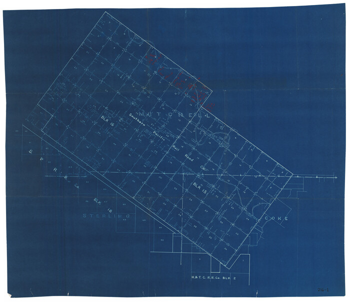
Print $20.00
- Digital $50.00
[Southern Pacific Rail Road Co. Blocks 15 and 16 in Mitchell, Sterling and Coke Counties]
Size: 34.5 x 29.2 inches
91838
[Southern Pacific Rail Road Co. Blocks 15 and 16 in Mitchell, Sterling and Coke Counties]
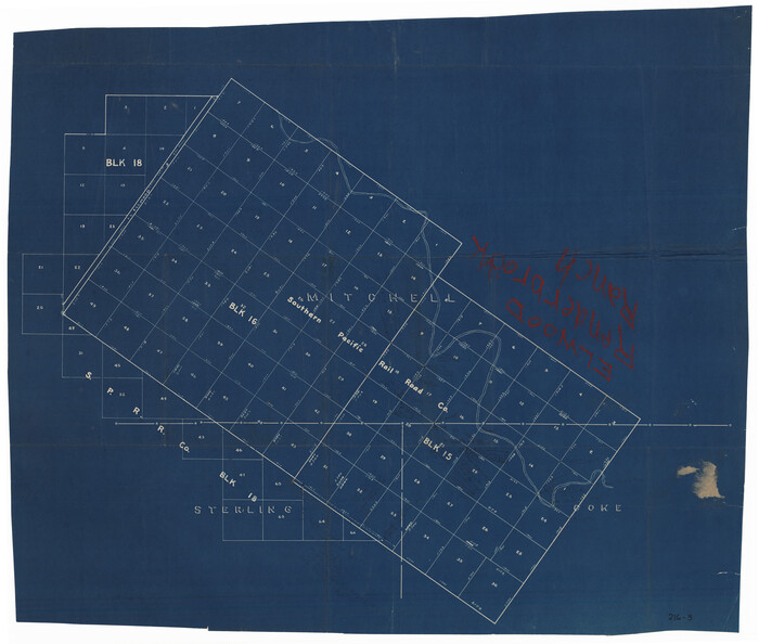
Print $20.00
- Digital $50.00
[Southern Pacific Rail Road Co. Blocks 15 and 16 in Mitchell, Sterling and Coke Counties]
Size: 30.5 x 35.7 inches
91839
[S.P.R.R.Co. Blocks 15 &16]
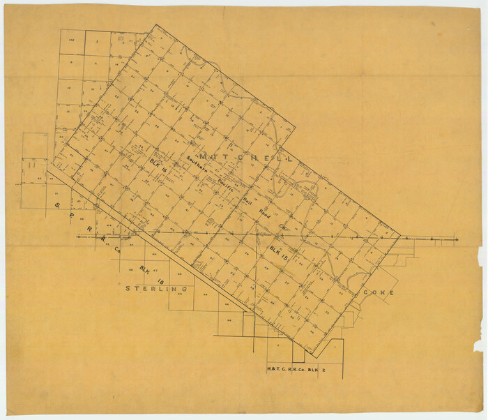
Print $20.00
- Digital $50.00
[S.P.R.R.Co. Blocks 15 &16]
Size: 37.3 x 32.3 inches
92355
[Map of Sterling County]
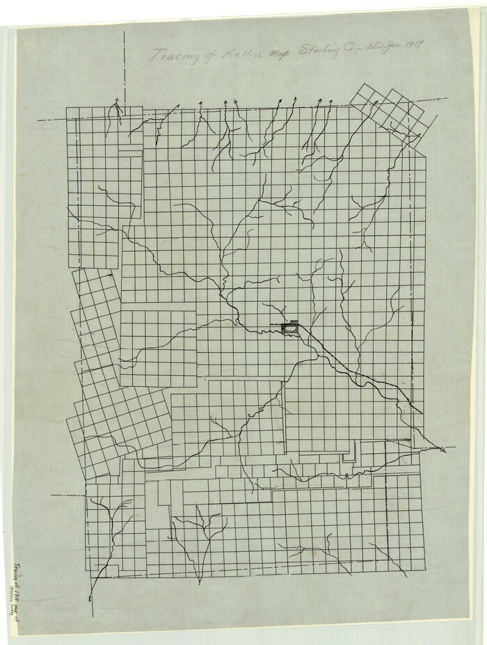
Print $20.00
- Digital $50.00
[Map of Sterling County]
1919
Size: 30.2 x 22.8 inches
4055
Working Sketch in Mitchell, Sterling, and Coke Co's.

Print $20.00
- Digital $50.00
Working Sketch in Mitchell, Sterling, and Coke Co's.
1925
Size: 34.2 x 30.7 inches
91840
Water-Shed of the Colorado River

Print $40.00
- Digital $50.00
Water-Shed of the Colorado River
1925
Size: 37.1 x 79.8 inches
65261
Tom Green County Working Sketch 2

Print $20.00
- Digital $50.00
Tom Green County Working Sketch 2
1917
Size: 21.1 x 32.9 inches
69371
Tom Green County Working Sketch 15

Print $20.00
- Digital $50.00
Tom Green County Working Sketch 15
1988
Size: 32.9 x 37.5 inches
69384
Tom Green County Sketch File 63

Print $20.00
- Digital $50.00
Tom Green County Sketch File 63
1890
Size: 31.8 x 17.9 inches
12445
Tom Green County Sketch File 62

Print $20.00
- Digital $50.00
Tom Green County Sketch File 62
1890
Size: 27.7 x 43.9 inches
10405
Tom Green County Sketch File 3

Print $20.00
- Digital $50.00
Tom Green County Sketch File 3
Size: 29.7 x 40.5 inches
10400
Tom Green County Rolled Sketch 3

Print $20.00
- Digital $50.00
Tom Green County Rolled Sketch 3
Size: 26.8 x 32.8 inches
7993
Sterling County Working Sketch Graphic Index

Print $20.00
- Digital $50.00
Sterling County Working Sketch Graphic Index
1971
Size: 45.5 x 36.3 inches
76703
Sterling County Working Sketch 9

Print $20.00
- Digital $50.00
Sterling County Working Sketch 9
1980
Size: 30.3 x 41.1 inches
63991
Sterling County Working Sketch 8

Print $20.00
- Digital $50.00
Sterling County Working Sketch 8
1972
Size: 40.7 x 35.9 inches
63990
Sterling County Working Sketch 7

Print $20.00
- Digital $50.00
Sterling County Working Sketch 7
1957
Size: 22.1 x 26.1 inches
63989
Sterling County Working Sketch 6

Print $40.00
- Digital $50.00
Sterling County Working Sketch 6
1955
Size: 38.1 x 121.6 inches
63988
Sterling County Working Sketch 5

Print $20.00
- Digital $50.00
Sterling County Working Sketch 5
1954
Size: 18.9 x 34.9 inches
63987
Sterling County Working Sketch 4

Print $40.00
- Digital $50.00
Sterling County Working Sketch 4
1950
Size: 49.7 x 42.5 inches
63986
Sterling County Working Sketch 3

Print $40.00
- Digital $50.00
Sterling County Working Sketch 3
1948
Size: 43.6 x 55.2 inches
63985
Sterling County Working Sketch 2

Print $20.00
- Digital $50.00
Sterling County Working Sketch 2
1941
Size: 19.9 x 26.2 inches
63984
Sterling County Working Sketch 12

Print $20.00
- Digital $50.00
Sterling County Working Sketch 12
1989
Size: 26.0 x 36.5 inches
63994
Sterling County Working Sketch 11

Print $20.00
- Digital $50.00
Sterling County Working Sketch 11
1987
Size: 20.1 x 40.8 inches
63993
Sterling County Working Sketch 10

Print $20.00
- Digital $50.00
Sterling County Working Sketch 10
1980
Size: 39.6 x 26.3 inches
63992
Sterling County Working Sketch 1

Print $20.00
- Digital $50.00
Sterling County Working Sketch 1
1926
Size: 30.3 x 29.6 inches
63983
Sterling County Sketch File D

Print $8.00
- Digital $50.00
Sterling County Sketch File D
Size: 11.2 x 8.6 inches
37157
Sterling County Sketch File A

Print $20.00
- Digital $50.00
Sterling County Sketch File A
1906
Size: 18.2 x 26.0 inches
12362
Sterling County Sketch File 8

Print $20.00
- Digital $50.00
Sterling County Sketch File 8
1916
Size: 27.2 x 25.2 inches
12357
Sterling County Sketch File 7

Print $25.00
- Digital $50.00
Sterling County Sketch File 7
1926
Size: 11.7 x 12.1 inches
37121
[Tom Green County]
Print $20.00
- Digital $50.00
[Tom Green County]
1888
-
Size
33.2 x 34.4 inches
-
Map/Doc
16901
-
Creation Date
1888
[Southern Pacific Rail Road Co. Blocks 15 and 16 in Mitchell, Sterling and Coke Counties]
Print $20.00
- Digital $50.00
[Southern Pacific Rail Road Co. Blocks 15 and 16 in Mitchell, Sterling and Coke Counties]
-
Size
34.5 x 29.2 inches
-
Map/Doc
91838
[Southern Pacific Rail Road Co. Blocks 15 and 16 in Mitchell, Sterling and Coke Counties]
Print $20.00
- Digital $50.00
[Southern Pacific Rail Road Co. Blocks 15 and 16 in Mitchell, Sterling and Coke Counties]
-
Size
30.5 x 35.7 inches
-
Map/Doc
91839
[S.P.R.R.Co. Blocks 15 &16]
Print $20.00
- Digital $50.00
[S.P.R.R.Co. Blocks 15 &16]
-
Size
37.3 x 32.3 inches
-
Map/Doc
92355
[Map of Sterling County]
Print $20.00
- Digital $50.00
[Map of Sterling County]
1919
-
Size
30.2 x 22.8 inches
-
Map/Doc
4055
-
Creation Date
1919
Working Sketch in Mitchell, Sterling, and Coke Co's.
Print $20.00
- Digital $50.00
Working Sketch in Mitchell, Sterling, and Coke Co's.
1925
-
Size
34.2 x 30.7 inches
-
Map/Doc
91840
-
Creation Date
1925
Water-Shed of the Colorado River
Print $40.00
- Digital $50.00
Water-Shed of the Colorado River
1925
-
Size
37.1 x 79.8 inches
-
Map/Doc
65261
-
Creation Date
1925
Tom Green County Working Sketch 2
Print $20.00
- Digital $50.00
Tom Green County Working Sketch 2
1917
-
Size
21.1 x 32.9 inches
-
Map/Doc
69371
-
Creation Date
1917
Tom Green County Working Sketch 15
Print $20.00
- Digital $50.00
Tom Green County Working Sketch 15
1988
-
Size
32.9 x 37.5 inches
-
Map/Doc
69384
-
Creation Date
1988
Tom Green County Sketch File 63
Print $20.00
- Digital $50.00
Tom Green County Sketch File 63
1890
-
Size
31.8 x 17.9 inches
-
Map/Doc
12445
-
Creation Date
1890
Tom Green County Sketch File 62
Print $20.00
- Digital $50.00
Tom Green County Sketch File 62
1890
-
Size
27.7 x 43.9 inches
-
Map/Doc
10405
-
Creation Date
1890
Tom Green County Sketch File 3
Print $20.00
- Digital $50.00
Tom Green County Sketch File 3
-
Size
29.7 x 40.5 inches
-
Map/Doc
10400
Tom Green County Rolled Sketch 3
Print $20.00
- Digital $50.00
Tom Green County Rolled Sketch 3
-
Size
26.8 x 32.8 inches
-
Map/Doc
7993
Sterling County Working Sketch Graphic Index
Print $20.00
- Digital $50.00
Sterling County Working Sketch Graphic Index
1971
-
Size
45.5 x 36.3 inches
-
Map/Doc
76703
-
Creation Date
1971
Sterling County Working Sketch 9
Print $20.00
- Digital $50.00
Sterling County Working Sketch 9
1980
-
Size
30.3 x 41.1 inches
-
Map/Doc
63991
-
Creation Date
1980
Sterling County Working Sketch 8
Print $20.00
- Digital $50.00
Sterling County Working Sketch 8
1972
-
Size
40.7 x 35.9 inches
-
Map/Doc
63990
-
Creation Date
1972
Sterling County Working Sketch 7
Print $20.00
- Digital $50.00
Sterling County Working Sketch 7
1957
-
Size
22.1 x 26.1 inches
-
Map/Doc
63989
-
Creation Date
1957
Sterling County Working Sketch 6
Print $40.00
- Digital $50.00
Sterling County Working Sketch 6
1955
-
Size
38.1 x 121.6 inches
-
Map/Doc
63988
-
Creation Date
1955
Sterling County Working Sketch 5
Print $20.00
- Digital $50.00
Sterling County Working Sketch 5
1954
-
Size
18.9 x 34.9 inches
-
Map/Doc
63987
-
Creation Date
1954
Sterling County Working Sketch 4
Print $40.00
- Digital $50.00
Sterling County Working Sketch 4
1950
-
Size
49.7 x 42.5 inches
-
Map/Doc
63986
-
Creation Date
1950
Sterling County Working Sketch 3
Print $40.00
- Digital $50.00
Sterling County Working Sketch 3
1948
-
Size
43.6 x 55.2 inches
-
Map/Doc
63985
-
Creation Date
1948
Sterling County Working Sketch 2
Print $20.00
- Digital $50.00
Sterling County Working Sketch 2
1941
-
Size
19.9 x 26.2 inches
-
Map/Doc
63984
-
Creation Date
1941
Sterling County Working Sketch 12
Print $20.00
- Digital $50.00
Sterling County Working Sketch 12
1989
-
Size
26.0 x 36.5 inches
-
Map/Doc
63994
-
Creation Date
1989
Sterling County Working Sketch 11
Print $20.00
- Digital $50.00
Sterling County Working Sketch 11
1987
-
Size
20.1 x 40.8 inches
-
Map/Doc
63993
-
Creation Date
1987
Sterling County Working Sketch 10
Print $20.00
- Digital $50.00
Sterling County Working Sketch 10
1980
-
Size
39.6 x 26.3 inches
-
Map/Doc
63992
-
Creation Date
1980
Sterling County Working Sketch 1
Print $20.00
- Digital $50.00
Sterling County Working Sketch 1
1926
-
Size
30.3 x 29.6 inches
-
Map/Doc
63983
-
Creation Date
1926
Sterling County Sketch File D
Print $8.00
- Digital $50.00
Sterling County Sketch File D
-
Size
11.2 x 8.6 inches
-
Map/Doc
37157
Sterling County Sketch File A
Print $20.00
- Digital $50.00
Sterling County Sketch File A
1906
-
Size
18.2 x 26.0 inches
-
Map/Doc
12362
-
Creation Date
1906
Sterling County Sketch File 8
Print $20.00
- Digital $50.00
Sterling County Sketch File 8
1916
-
Size
27.2 x 25.2 inches
-
Map/Doc
12357
-
Creation Date
1916
Sterling County Sketch File 7
Print $25.00
- Digital $50.00
Sterling County Sketch File 7
1926
-
Size
11.7 x 12.1 inches
-
Map/Doc
37121
-
Creation Date
1926