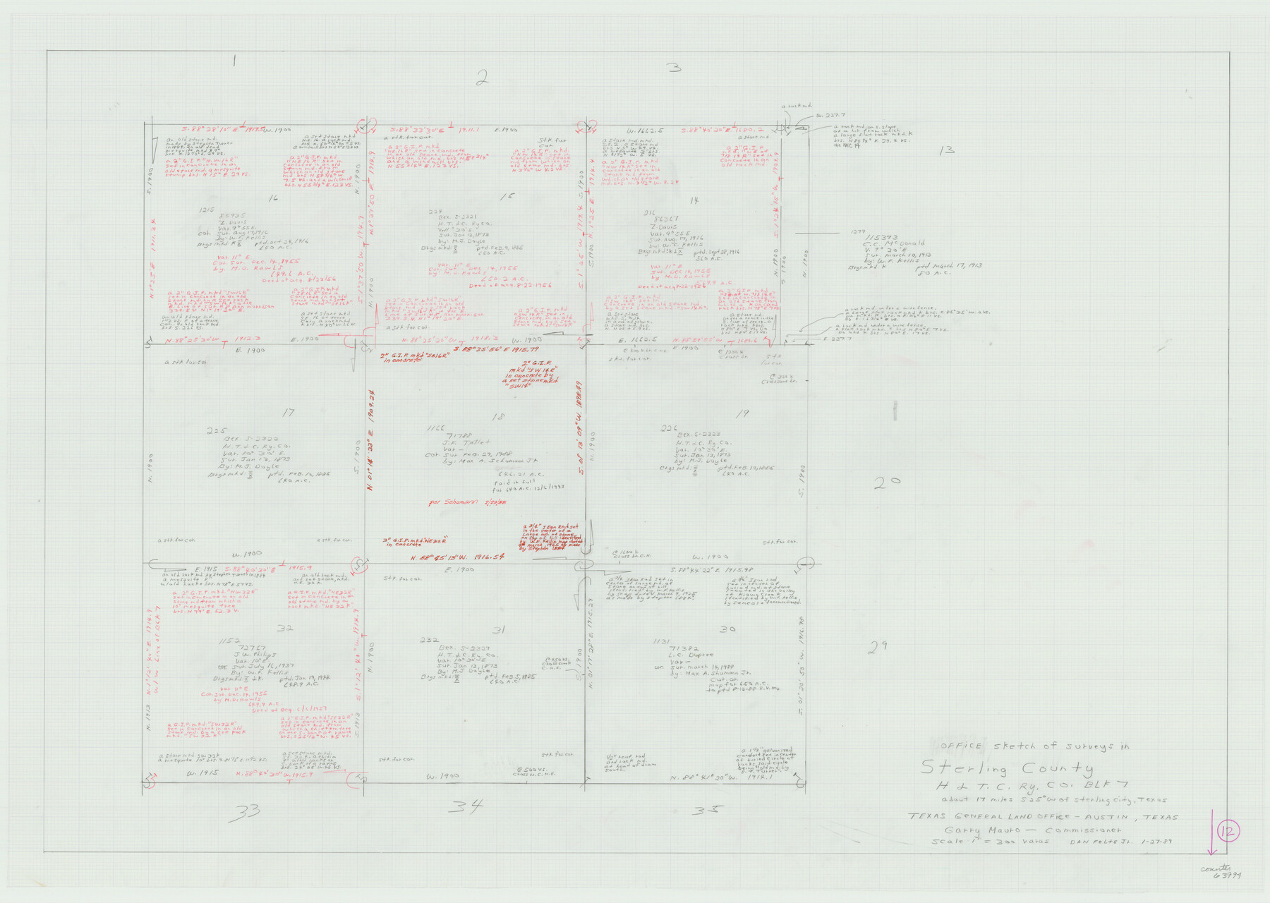
Sterling County Working Sketch 12
-
Map/Doc
63994
-
Collection
General Map Collection
-
Object Dates
1/27/1989 (Creation Date)
-
People and Organizations
Dan Felts, Jr. (Draftsman)
-
Counties
Sterling
-
Subjects
Surveying Working Sketch
-
Height x Width
26.0 x 36.5 inches
66.0 x 92.7 cm
-
Scale
1" = 300 varas
Part of: General Map Collection
A Geographically Correct Map of the State of Texas

Print $20.00
- Digital $50.00
A Geographically Correct Map of the State of Texas
1876
Size 20.4 x 21.7 inches
Map/Doc 95361
Zapata County Sketch File 5

Print $20.00
- Digital $50.00
Zapata County Sketch File 5
1886
Size 15.4 x 16.9 inches
Map/Doc 12719
Eastland County Sketch File 17

Print $18.00
- Digital $50.00
Eastland County Sketch File 17
1918
Size 13.6 x 8.9 inches
Map/Doc 21600
Morris County Sketch File 3

Print $2.00
- Digital $50.00
Morris County Sketch File 3
Size 12.0 x 5.0 inches
Map/Doc 31967
[Surveys in the Jefferson District]
![3177, [Surveys in the Jefferson District], General Map Collection](https://historictexasmaps.com/wmedia_w700/maps/3177.tif.jpg)
Print $2.00
- Digital $50.00
[Surveys in the Jefferson District]
1841
Size 9.8 x 8.0 inches
Map/Doc 3177
Meanders of Sulphur Fork of Red River, Red River County, Texas
Print $2.00
- Digital $50.00
Meanders of Sulphur Fork of Red River, Red River County, Texas
1841
Size 9.9 x 8.1 inches
Map/Doc 65785
Brazoria County Working Sketch 19

Print $40.00
- Digital $50.00
Brazoria County Working Sketch 19
1951
Size 50.3 x 42.3 inches
Map/Doc 67504
Gillespie County Boundary File 4

Print $56.00
- Digital $50.00
Gillespie County Boundary File 4
Size 13.6 x 9.0 inches
Map/Doc 53754
Tom Green County Sketch File 50

Print $20.00
- Digital $50.00
Tom Green County Sketch File 50
1884
Size 25.4 x 34.5 inches
Map/Doc 12442
Map of the Fort Worth and Denver City Railway, through Wilbarger County Texas, 1882

Print $40.00
- Digital $50.00
Map of the Fort Worth and Denver City Railway, through Wilbarger County Texas, 1882
Size 22.6 x 79.4 inches
Map/Doc 64427
Flight Mission No. CGI-4N, Frame 176, Cameron County

Print $20.00
- Digital $50.00
Flight Mission No. CGI-4N, Frame 176, Cameron County
1955
Size 18.5 x 22.2 inches
Map/Doc 84679
Flight Mission No. DQN-2K, Frame 32, Calhoun County

Print $20.00
- Digital $50.00
Flight Mission No. DQN-2K, Frame 32, Calhoun County
1953
Size 18.7 x 22.3 inches
Map/Doc 84239
You may also like
General Highway Map, Dawson County, Texas

Print $20.00
General Highway Map, Dawson County, Texas
1961
Size 18.0 x 24.5 inches
Map/Doc 79436
Hutchinson County Rolled Sketch 2

Print $20.00
- Digital $50.00
Hutchinson County Rolled Sketch 2
Size 36.1 x 42.0 inches
Map/Doc 76069
Jefferson County Sketch File 18

Print $40.00
- Digital $50.00
Jefferson County Sketch File 18
Size 15.7 x 14.0 inches
Map/Doc 28167

Flight Mission No. BRA-16M, Frame 147, Jefferson County

Print $20.00
- Digital $50.00
Flight Mission No. BRA-16M, Frame 147, Jefferson County
1953
Size 18.6 x 22.3 inches
Map/Doc 85753
Blks. A, T2, T3, S3, K13 and vicinity]
![92195, Blks. A, T2, T3, S3, K13 and vicinity], Twichell Survey Records](https://historictexasmaps.com/wmedia_w700/maps/92195-1.tif.jpg)
Print $20.00
- Digital $50.00
Blks. A, T2, T3, S3, K13 and vicinity]
Size 13.8 x 13.6 inches
Map/Doc 92195
Dimmit County Working Sketch 21

Print $20.00
- Digital $50.00
Dimmit County Working Sketch 21
1950
Size 35.1 x 18.8 inches
Map/Doc 68682
Red River County Working Sketch 47

Print $20.00
- Digital $50.00
Red River County Working Sketch 47
1969
Size 34.3 x 24.2 inches
Map/Doc 72030
![91112, [Block 1], Twichell Survey Records](https://historictexasmaps.com/wmedia_w700/maps/91112-1.tif.jpg)
Stonewall County Rolled Sketch 11A

Print $20.00
- Digital $50.00
Stonewall County Rolled Sketch 11A
Size 33.4 x 28.2 inches
Map/Doc 7868
Starr County Rolled Sketch 28

Print $20.00
- Digital $50.00
Starr County Rolled Sketch 28
1941
Size 29.0 x 20.6 inches
Map/Doc 7811
Flight Mission No. CUG-3P, Frame 137, Kleberg County

Print $20.00
- Digital $50.00
Flight Mission No. CUG-3P, Frame 137, Kleberg County
1956
Size 18.4 x 22.2 inches
Map/Doc 86272