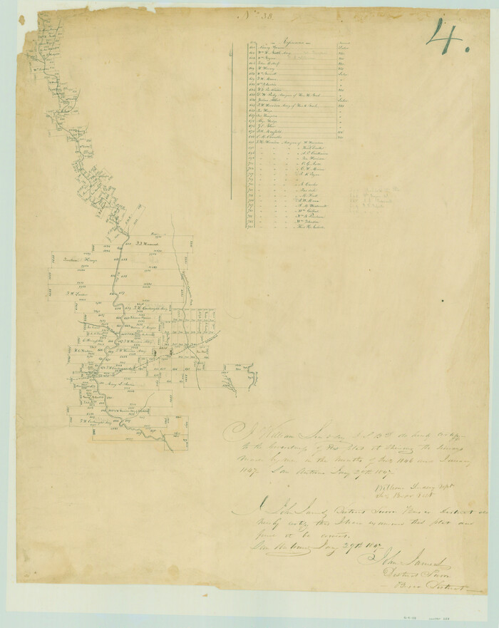
[Surveys in the Bexar District along the Frio River and Commanche [sic] Creek]
Print $20.00
- Digital $50.00
[Surveys in the Bexar District along the Frio River and Commanche [sic] Creek]
1846
Size: 23.8 x 18.9 inches
228
Uvalde County Working Sketch 17

Print $20.00
- Digital $50.00
Uvalde County Working Sketch 17
1947
Size: 27.5 x 37.3 inches
72087
Uvalde County Sketch File 20a

Print $20.00
- Digital $50.00
Uvalde County Sketch File 20a
1911
Size: 22.7 x 23.8 inches
12532
Uvalde County Rolled Sketch 8

Print $20.00
- Digital $50.00
Uvalde County Rolled Sketch 8
Size: 21.3 x 37.5 inches
8093
Real County Working Sketch Graphic Index, Sheet 2 (Sketches 43 to Most Recent)

Print $20.00
- Digital $50.00
Real County Working Sketch Graphic Index, Sheet 2 (Sketches 43 to Most Recent)
1972
Size: 43.2 x 31.1 inches
76679
Real County Working Sketch Graphic Index, Sheet 1 (Sketches 1 to 42)

Print $20.00
- Digital $50.00
Real County Working Sketch Graphic Index, Sheet 1 (Sketches 1 to 42)
1972
Size: 42.9 x 31.0 inches
76678
Real County Working Sketch 91

Print $20.00
- Digital $50.00
Real County Working Sketch 91
1996
Size: 22.0 x 20.0 inches
71983
Real County Working Sketch 90

Print $20.00
- Digital $50.00
Real County Working Sketch 90
1991
Size: 16.7 x 22.8 inches
71982
Real County Working Sketch 9

Print $20.00
- Digital $50.00
Real County Working Sketch 9
1929
Size: 18.4 x 19.5 inches
71901
Real County Working Sketch 89

Print $20.00
- Digital $50.00
Real County Working Sketch 89
Size: 28.0 x 37.1 inches
71981
Real County Working Sketch 88

Print $20.00
- Digital $50.00
Real County Working Sketch 88
1989
Size: 23.9 x 27.0 inches
71980
Real County Working Sketch 87

Print $20.00
- Digital $50.00
Real County Working Sketch 87
1988
Size: 30.9 x 29.6 inches
71979
Real County Working Sketch 86

Print $20.00
- Digital $50.00
Real County Working Sketch 86
1988
Size: 37.8 x 26.6 inches
71978
Real County Working Sketch 85

Print $20.00
- Digital $50.00
Real County Working Sketch 85
1988
Size: 27.0 x 30.0 inches
71977
Real County Working Sketch 84

Print $20.00
- Digital $50.00
Real County Working Sketch 84
1986
Size: 25.0 x 40.7 inches
71976
Real County Working Sketch 83

Print $20.00
- Digital $50.00
Real County Working Sketch 83
1986
Size: 25.7 x 43.0 inches
71975
Real County Working Sketch 82

Print $20.00
- Digital $50.00
Real County Working Sketch 82
1985
Size: 24.9 x 23.5 inches
71974
Real County Working Sketch 81

Print $20.00
- Digital $50.00
Real County Working Sketch 81
1984
Size: 19.9 x 17.1 inches
71973
Real County Working Sketch 80

Print $20.00
- Digital $50.00
Real County Working Sketch 80
1984
Size: 37.9 x 43.3 inches
71972
Real County Working Sketch 8

Print $20.00
- Digital $50.00
Real County Working Sketch 8
1928
Size: 38.1 x 44.3 inches
71900
Real County Working Sketch 79

Print $20.00
- Digital $50.00
Real County Working Sketch 79
1981
Size: 19.8 x 22.2 inches
71971
Real County Working Sketch 78

Print $20.00
- Digital $50.00
Real County Working Sketch 78
1980
Size: 33.9 x 35.5 inches
71970
Real County Working Sketch 77

Print $20.00
- Digital $50.00
Real County Working Sketch 77
1980
Size: 33.1 x 33.3 inches
71969
Real County Working Sketch 76

Print $20.00
- Digital $50.00
Real County Working Sketch 76
1979
Size: 30.6 x 21.1 inches
71968
Real County Working Sketch 75

Print $20.00
- Digital $50.00
Real County Working Sketch 75
1979
Size: 29.0 x 28.6 inches
71967
Real County Working Sketch 74

Print $20.00
- Digital $50.00
Real County Working Sketch 74
1979
Size: 17.1 x 23.5 inches
71966
Real County Working Sketch 73

Print $20.00
- Digital $50.00
Real County Working Sketch 73
1978
Size: 28.2 x 24.9 inches
71965
Real County Working Sketch 72

Print $20.00
- Digital $50.00
Real County Working Sketch 72
1976
Size: 47.3 x 43.3 inches
71964
Real County Working Sketch 71

Print $20.00
- Digital $50.00
Real County Working Sketch 71
1976
Size: 31.8 x 29.1 inches
71963
[Surveys in the Bexar District along the Frio River and Commanche [sic] Creek]
Print $20.00
- Digital $50.00
[Surveys in the Bexar District along the Frio River and Commanche [sic] Creek]
1846
-
Size
23.8 x 18.9 inches
-
Map/Doc
228
-
Creation Date
1846
Uvalde County Working Sketch 17
Print $20.00
- Digital $50.00
Uvalde County Working Sketch 17
1947
-
Size
27.5 x 37.3 inches
-
Map/Doc
72087
-
Creation Date
1947
Uvalde County Sketch File 20a
Print $20.00
- Digital $50.00
Uvalde County Sketch File 20a
1911
-
Size
22.7 x 23.8 inches
-
Map/Doc
12532
-
Creation Date
1911
Uvalde County Rolled Sketch 8
Print $20.00
- Digital $50.00
Uvalde County Rolled Sketch 8
-
Size
21.3 x 37.5 inches
-
Map/Doc
8093
Texas Hill Country Trail Region

Texas Hill Country Trail Region
2017
-
Size
18.2 x 24.3 inches
-
Map/Doc
96871
-
Creation Date
2017
Real County Working Sketch Graphic Index, Sheet 2 (Sketches 43 to Most Recent)
Print $20.00
- Digital $50.00
Real County Working Sketch Graphic Index, Sheet 2 (Sketches 43 to Most Recent)
1972
-
Size
43.2 x 31.1 inches
-
Map/Doc
76679
-
Creation Date
1972
Real County Working Sketch Graphic Index, Sheet 1 (Sketches 1 to 42)
Print $20.00
- Digital $50.00
Real County Working Sketch Graphic Index, Sheet 1 (Sketches 1 to 42)
1972
-
Size
42.9 x 31.0 inches
-
Map/Doc
76678
-
Creation Date
1972
Real County Working Sketch 91
Print $20.00
- Digital $50.00
Real County Working Sketch 91
1996
-
Size
22.0 x 20.0 inches
-
Map/Doc
71983
-
Creation Date
1996
Real County Working Sketch 90
Print $20.00
- Digital $50.00
Real County Working Sketch 90
1991
-
Size
16.7 x 22.8 inches
-
Map/Doc
71982
-
Creation Date
1991
Real County Working Sketch 9
Print $20.00
- Digital $50.00
Real County Working Sketch 9
1929
-
Size
18.4 x 19.5 inches
-
Map/Doc
71901
-
Creation Date
1929
Real County Working Sketch 89
Print $20.00
- Digital $50.00
Real County Working Sketch 89
-
Size
28.0 x 37.1 inches
-
Map/Doc
71981
Real County Working Sketch 88
Print $20.00
- Digital $50.00
Real County Working Sketch 88
1989
-
Size
23.9 x 27.0 inches
-
Map/Doc
71980
-
Creation Date
1989
Real County Working Sketch 87
Print $20.00
- Digital $50.00
Real County Working Sketch 87
1988
-
Size
30.9 x 29.6 inches
-
Map/Doc
71979
-
Creation Date
1988
Real County Working Sketch 86
Print $20.00
- Digital $50.00
Real County Working Sketch 86
1988
-
Size
37.8 x 26.6 inches
-
Map/Doc
71978
-
Creation Date
1988
Real County Working Sketch 85
Print $20.00
- Digital $50.00
Real County Working Sketch 85
1988
-
Size
27.0 x 30.0 inches
-
Map/Doc
71977
-
Creation Date
1988
Real County Working Sketch 84
Print $20.00
- Digital $50.00
Real County Working Sketch 84
1986
-
Size
25.0 x 40.7 inches
-
Map/Doc
71976
-
Creation Date
1986
Real County Working Sketch 83
Print $20.00
- Digital $50.00
Real County Working Sketch 83
1986
-
Size
25.7 x 43.0 inches
-
Map/Doc
71975
-
Creation Date
1986
Real County Working Sketch 82
Print $20.00
- Digital $50.00
Real County Working Sketch 82
1985
-
Size
24.9 x 23.5 inches
-
Map/Doc
71974
-
Creation Date
1985
Real County Working Sketch 81
Print $20.00
- Digital $50.00
Real County Working Sketch 81
1984
-
Size
19.9 x 17.1 inches
-
Map/Doc
71973
-
Creation Date
1984
Real County Working Sketch 80
Print $20.00
- Digital $50.00
Real County Working Sketch 80
1984
-
Size
37.9 x 43.3 inches
-
Map/Doc
71972
-
Creation Date
1984
Real County Working Sketch 8
Print $20.00
- Digital $50.00
Real County Working Sketch 8
1928
-
Size
38.1 x 44.3 inches
-
Map/Doc
71900
-
Creation Date
1928
Real County Working Sketch 79
Print $20.00
- Digital $50.00
Real County Working Sketch 79
1981
-
Size
19.8 x 22.2 inches
-
Map/Doc
71971
-
Creation Date
1981
Real County Working Sketch 78
Print $20.00
- Digital $50.00
Real County Working Sketch 78
1980
-
Size
33.9 x 35.5 inches
-
Map/Doc
71970
-
Creation Date
1980
Real County Working Sketch 77
Print $20.00
- Digital $50.00
Real County Working Sketch 77
1980
-
Size
33.1 x 33.3 inches
-
Map/Doc
71969
-
Creation Date
1980
Real County Working Sketch 76
Print $20.00
- Digital $50.00
Real County Working Sketch 76
1979
-
Size
30.6 x 21.1 inches
-
Map/Doc
71968
-
Creation Date
1979
Real County Working Sketch 75
Print $20.00
- Digital $50.00
Real County Working Sketch 75
1979
-
Size
29.0 x 28.6 inches
-
Map/Doc
71967
-
Creation Date
1979
Real County Working Sketch 74
Print $20.00
- Digital $50.00
Real County Working Sketch 74
1979
-
Size
17.1 x 23.5 inches
-
Map/Doc
71966
-
Creation Date
1979
Real County Working Sketch 73
Print $20.00
- Digital $50.00
Real County Working Sketch 73
1978
-
Size
28.2 x 24.9 inches
-
Map/Doc
71965
-
Creation Date
1978
Real County Working Sketch 72
Print $20.00
- Digital $50.00
Real County Working Sketch 72
1976
-
Size
47.3 x 43.3 inches
-
Map/Doc
71964
-
Creation Date
1976
Real County Working Sketch 71
Print $20.00
- Digital $50.00
Real County Working Sketch 71
1976
-
Size
31.8 x 29.1 inches
-
Map/Doc
71963
-
Creation Date
1976