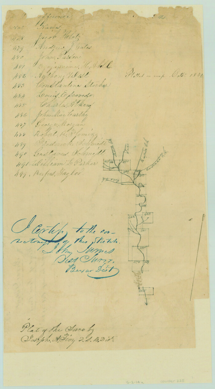
[Surveys near Seco Creek]
Print $2.00
- Digital $50.00
[Surveys near Seco Creek]
1846
Size: 13.1 x 7.3 inches
225
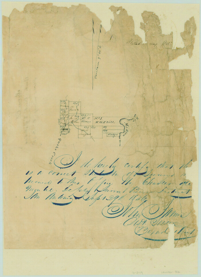
[Surveys near Quihi Creek]
Print $2.00
- Digital $50.00
[Surveys near Quihi Creek]
1846
Size: 11.0 x 8.0 inches
312
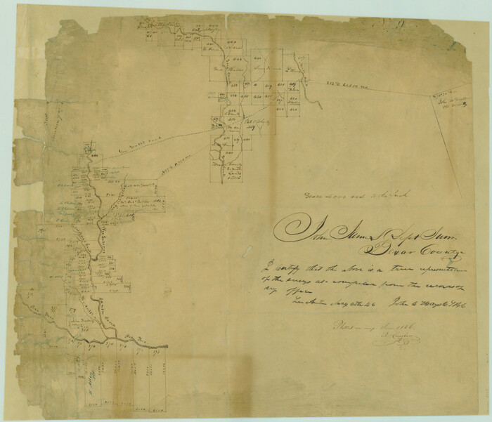
[Surveys in the Bexar District along the Sabinal and Frio Rivers]
Print $20.00
- Digital $50.00
[Surveys in the Bexar District along the Sabinal and Frio Rivers]
1846
Size: 16.8 x 19.6 inches
3167
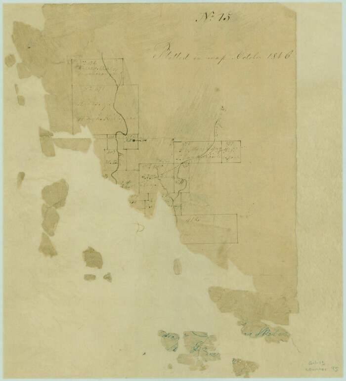
[Surveys in the Bexar District along the Sabinal River and Rancheros Creek]
Print $2.00
- Digital $50.00
[Surveys in the Bexar District along the Sabinal River and Rancheros Creek]
1846
Size: 8.6 x 7.8 inches
95
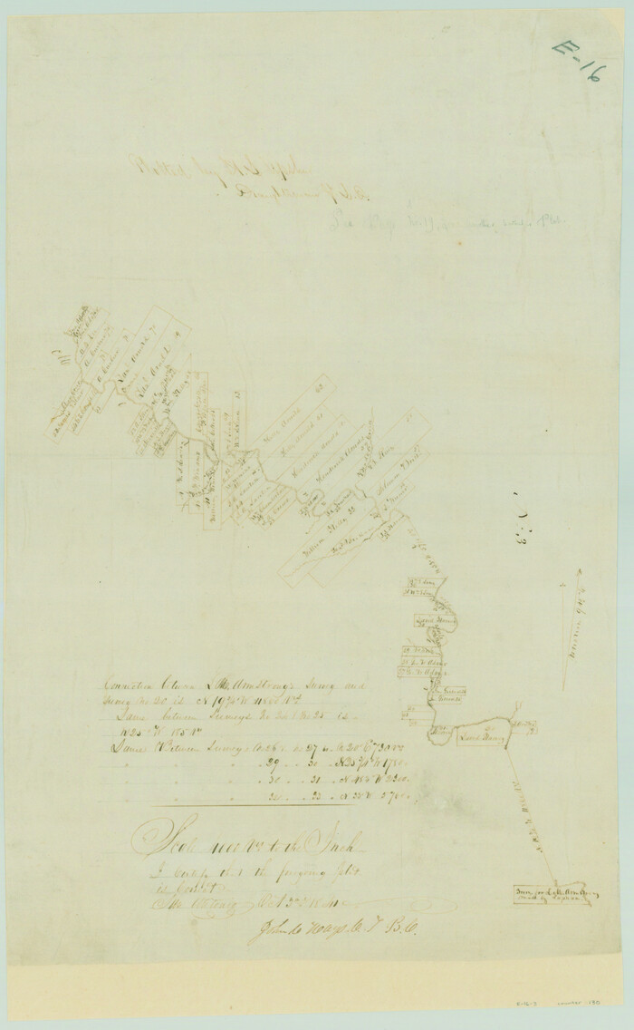
[Surveys in the Bexar District along the Medina River]
Print $20.00
- Digital $50.00
[Surveys in the Bexar District along the Medina River]
1841
Size: 20.7 x 12.8 inches
130
[Surveys in the Bexar District along the Frio River]
Print $2.00
- Digital $50.00
[Surveys in the Bexar District along the Frio River]
1847
Size: 15.8 x 9.2 inches
315
[Surveys in the Bexar District along Hondo and Seco Creeks]
Print $3.00
- Digital $50.00
[Surveys in the Bexar District along Hondo and Seco Creeks]
1847
Size: 9.3 x 9.9 inches
314
[Surveys along the Medina River]

Print $2.00
- Digital $50.00
[Surveys along the Medina River]
1840
Size: 8.2 x 14.3 inches
52
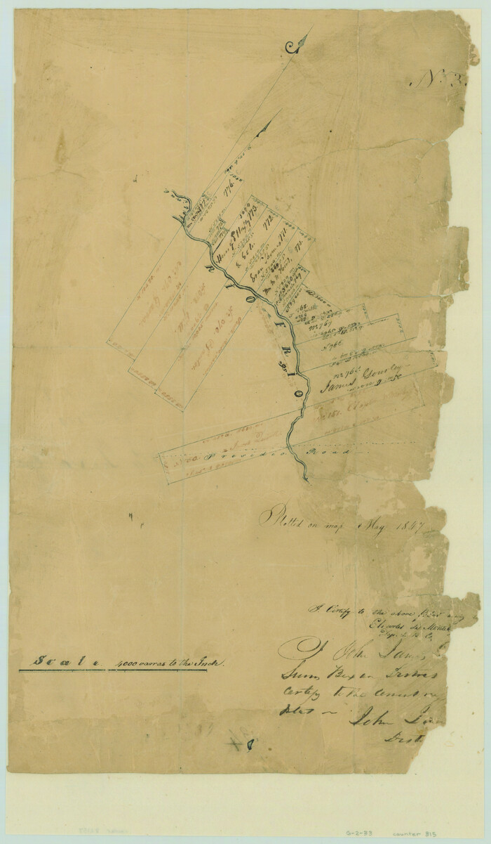
[Surveys along the Frio River at the confluence of the Sabinal River]
Print $2.00
- Digital $50.00
[Surveys along the Frio River at the confluence of the Sabinal River]
1845
Size: 6.2 x 8.9 inches
78372
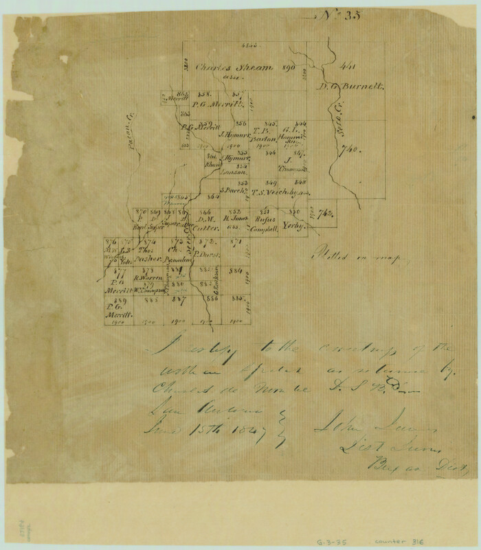
[Surveys along Seco, Pecan and Deer Creeks]
Print $2.00
- Digital $50.00
[Surveys along Seco, Pecan and Deer Creeks]
1847
Size: 8.9 x 7.8 inches
316
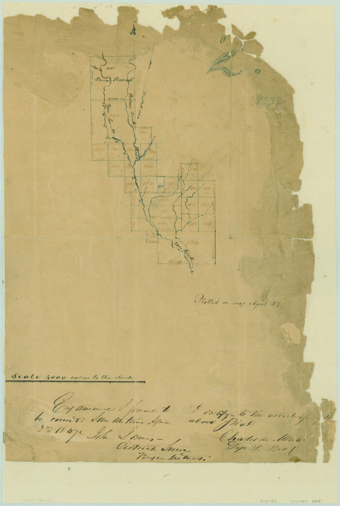
[Surveys along Seco Creek]
Print $3.00
- Digital $50.00
[Surveys along Seco Creek]
1847
Size: 14.6 x 9.8 inches
268
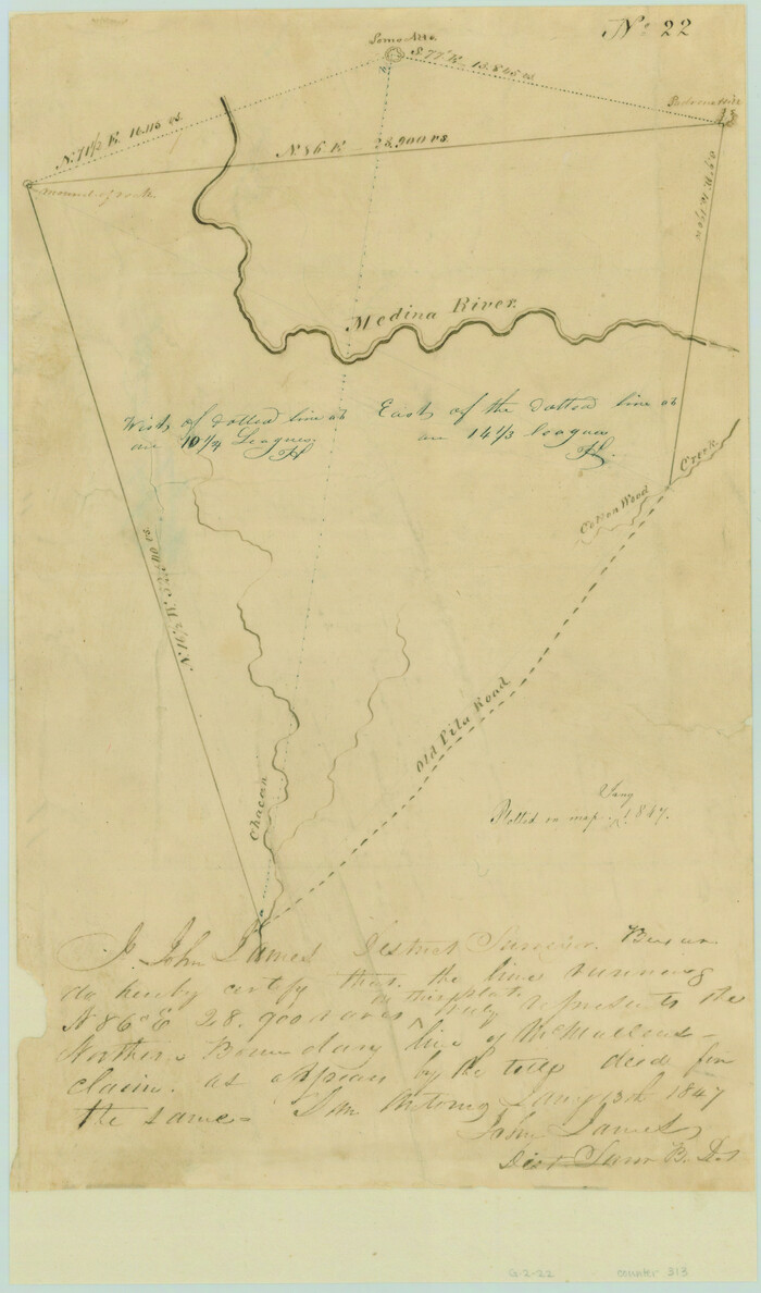
[Northern boundary line of McMullen's claim]
Print $2.00
- Digital $50.00
[Northern boundary line of McMullen's claim]
1847
Size: 13.5 x 8.0 inches
313
Uvalde County Working Sketch 7

Print $20.00
- Digital $50.00
Uvalde County Working Sketch 7
1942
Size: 29.2 x 30.0 inches
72077
Uvalde County Sketch File 7

Print $6.00
- Digital $50.00
Uvalde County Sketch File 7
Size: 14.5 x 11.4 inches
38962
Uvalde County Sketch File 26-2

Print $6.00
- Digital $50.00
Uvalde County Sketch File 26-2
1942
Size: 11.4 x 9.0 inches
39020
Uvalde County Rolled Sketch 6

Print $20.00
- Digital $50.00
Uvalde County Rolled Sketch 6
Size: 18.6 x 24.2 inches
8091
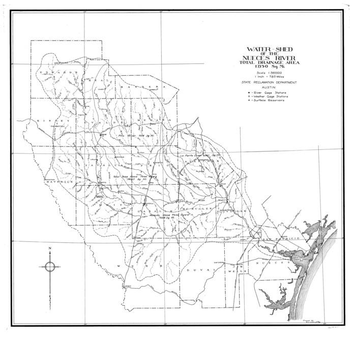
Nueces River, Water Shed [of the Nueces River]
Print $6.00
- Digital $50.00
Nueces River, Water Shed [of the Nueces River]
1925
Size: 33.6 x 35.4 inches
65101
Medina County, Texas

Print $20.00
- Digital $50.00
Medina County, Texas
1879
Size: 31.8 x 26.4 inches
579
Medina County Working Sketch Graphic Index

Print $40.00
- Digital $50.00
Medina County Working Sketch Graphic Index
1976
Size: 52.8 x 42.8 inches
76639
Medina County Working Sketch 9

Print $20.00
- Digital $50.00
Medina County Working Sketch 9
1959
Size: 25.3 x 38.8 inches
70924
Medina County Working Sketch 8

Print $20.00
- Digital $50.00
Medina County Working Sketch 8
1955
Size: 23.4 x 18.4 inches
70923
Medina County Working Sketch 7

Print $20.00
- Digital $50.00
Medina County Working Sketch 7
1952
Size: 26.3 x 28.5 inches
70922
Medina County Working Sketch 6

Print $20.00
- Digital $50.00
Medina County Working Sketch 6
1950
Size: 20.7 x 21.3 inches
70921
Medina County Working Sketch 5

Print $20.00
- Digital $50.00
Medina County Working Sketch 5
1949
Size: 38.5 x 37.3 inches
70920
Medina County Working Sketch 4

Print $40.00
- Digital $50.00
Medina County Working Sketch 4
1945
Size: 52.6 x 35.5 inches
70919
Medina County Working Sketch 33

Print $20.00
- Digital $50.00
Medina County Working Sketch 33
2006
Size: 34.5 x 40.0 inches
83607
Medina County Working Sketch 32

Print $20.00
- Digital $50.00
Medina County Working Sketch 32
1994
Size: 30.4 x 42.4 inches
70947
Medina County Working Sketch 31

Print $20.00
- Digital $50.00
Medina County Working Sketch 31
1993
Size: 27.2 x 20.8 inches
70946
[Surveys near Seco Creek]
Print $2.00
- Digital $50.00
[Surveys near Seco Creek]
1846
-
Size
13.1 x 7.3 inches
-
Map/Doc
225
-
Creation Date
1846
[Surveys near Quihi Creek]
Print $2.00
- Digital $50.00
[Surveys near Quihi Creek]
1846
-
Size
11.0 x 8.0 inches
-
Map/Doc
312
-
Creation Date
1846
[Surveys in the Bexar District along the Sabinal and Frio Rivers]
Print $20.00
- Digital $50.00
[Surveys in the Bexar District along the Sabinal and Frio Rivers]
1846
-
Size
16.8 x 19.6 inches
-
Map/Doc
3167
-
Creation Date
1846
[Surveys in the Bexar District along the Sabinal River and Rancheros Creek]
Print $2.00
- Digital $50.00
[Surveys in the Bexar District along the Sabinal River and Rancheros Creek]
1846
-
Size
8.6 x 7.8 inches
-
Map/Doc
95
-
Creation Date
1846
[Surveys in the Bexar District along the Medina River]
Print $20.00
- Digital $50.00
[Surveys in the Bexar District along the Medina River]
1841
-
Size
20.7 x 12.8 inches
-
Map/Doc
130
-
Creation Date
1841
[Surveys in the Bexar District along the Frio River]
Print $2.00
- Digital $50.00
[Surveys in the Bexar District along the Frio River]
1847
-
Size
15.8 x 9.2 inches
-
Map/Doc
315
-
Creation Date
1847
[Surveys in the Bexar District along Hondo and Seco Creeks]
Print $3.00
- Digital $50.00
[Surveys in the Bexar District along Hondo and Seco Creeks]
1847
-
Size
9.3 x 9.9 inches
-
Map/Doc
314
-
Creation Date
1847
[Surveys along the Medina River]
Print $2.00
- Digital $50.00
[Surveys along the Medina River]
1840
-
Size
8.2 x 14.3 inches
-
Map/Doc
52
-
Creation Date
1840
[Surveys along the Frio River at the confluence of the Sabinal River]
Print $2.00
- Digital $50.00
[Surveys along the Frio River at the confluence of the Sabinal River]
1845
-
Size
6.2 x 8.9 inches
-
Map/Doc
78372
-
Creation Date
1845
[Surveys along Seco, Pecan and Deer Creeks]
Print $2.00
- Digital $50.00
[Surveys along Seco, Pecan and Deer Creeks]
1847
-
Size
8.9 x 7.8 inches
-
Map/Doc
316
-
Creation Date
1847
[Surveys along Seco Creek]
Print $3.00
- Digital $50.00
[Surveys along Seco Creek]
1847
-
Size
14.6 x 9.8 inches
-
Map/Doc
268
-
Creation Date
1847
[Northern boundary line of McMullen's claim]
Print $2.00
- Digital $50.00
[Northern boundary line of McMullen's claim]
1847
-
Size
13.5 x 8.0 inches
-
Map/Doc
313
-
Creation Date
1847
Uvalde County Working Sketch 7
Print $20.00
- Digital $50.00
Uvalde County Working Sketch 7
1942
-
Size
29.2 x 30.0 inches
-
Map/Doc
72077
-
Creation Date
1942
Uvalde County Sketch File 7
Print $6.00
- Digital $50.00
Uvalde County Sketch File 7
-
Size
14.5 x 11.4 inches
-
Map/Doc
38962
Uvalde County Sketch File 26-2
Print $6.00
- Digital $50.00
Uvalde County Sketch File 26-2
1942
-
Size
11.4 x 9.0 inches
-
Map/Doc
39020
-
Creation Date
1942
Uvalde County Rolled Sketch 6
Print $20.00
- Digital $50.00
Uvalde County Rolled Sketch 6
-
Size
18.6 x 24.2 inches
-
Map/Doc
8091
Texas Hill Country Trail Region

Texas Hill Country Trail Region
2017
-
Size
18.2 x 24.3 inches
-
Map/Doc
96871
-
Creation Date
2017
Texas Hill Country Trail Region

Texas Hill Country Trail Region
-
Size
18.1 x 24.2 inches
-
Map/Doc
96872
Nueces River, Water Shed [of the Nueces River]
Print $6.00
- Digital $50.00
Nueces River, Water Shed [of the Nueces River]
1925
-
Size
33.6 x 35.4 inches
-
Map/Doc
65101
-
Creation Date
1925
Medina County, Texas
Print $20.00
- Digital $50.00
Medina County, Texas
1879
-
Size
31.8 x 26.4 inches
-
Map/Doc
579
-
Creation Date
1879
Medina County Working Sketch Graphic Index
Print $40.00
- Digital $50.00
Medina County Working Sketch Graphic Index
1976
-
Size
52.8 x 42.8 inches
-
Map/Doc
76639
-
Creation Date
1976
Medina County Working Sketch 9
Print $20.00
- Digital $50.00
Medina County Working Sketch 9
1959
-
Size
25.3 x 38.8 inches
-
Map/Doc
70924
-
Creation Date
1959
Medina County Working Sketch 8
Print $20.00
- Digital $50.00
Medina County Working Sketch 8
1955
-
Size
23.4 x 18.4 inches
-
Map/Doc
70923
-
Creation Date
1955
Medina County Working Sketch 7
Print $20.00
- Digital $50.00
Medina County Working Sketch 7
1952
-
Size
26.3 x 28.5 inches
-
Map/Doc
70922
-
Creation Date
1952
Medina County Working Sketch 6
Print $20.00
- Digital $50.00
Medina County Working Sketch 6
1950
-
Size
20.7 x 21.3 inches
-
Map/Doc
70921
-
Creation Date
1950
Medina County Working Sketch 5
Print $20.00
- Digital $50.00
Medina County Working Sketch 5
1949
-
Size
38.5 x 37.3 inches
-
Map/Doc
70920
-
Creation Date
1949
Medina County Working Sketch 4
Print $40.00
- Digital $50.00
Medina County Working Sketch 4
1945
-
Size
52.6 x 35.5 inches
-
Map/Doc
70919
-
Creation Date
1945
Medina County Working Sketch 33
Print $20.00
- Digital $50.00
Medina County Working Sketch 33
2006
-
Size
34.5 x 40.0 inches
-
Map/Doc
83607
-
Creation Date
2006
Medina County Working Sketch 32
Print $20.00
- Digital $50.00
Medina County Working Sketch 32
1994
-
Size
30.4 x 42.4 inches
-
Map/Doc
70947
-
Creation Date
1994
Medina County Working Sketch 31
Print $20.00
- Digital $50.00
Medina County Working Sketch 31
1993
-
Size
27.2 x 20.8 inches
-
Map/Doc
70946
-
Creation Date
1993