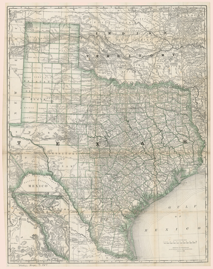
[Rand McNally's Indexed Map of Texas and Indian Territory]
Print $20.00
- Digital $50.00
[Rand McNally's Indexed Map of Texas and Indian Territory]
Size: 26.0 x 20.6 inches
93992
Traveller's Map of the State of Texas

Print $20.00
- Digital $50.00
Traveller's Map of the State of Texas
1867
Size: 43.6 x 41.7 inches
93935
The Rand-McNally New Commercial Atlas Map of Texas

Print $20.00
- Digital $50.00
The Rand-McNally New Commercial Atlas Map of Texas
Size: 29.5 x 40.3 inches
93993

Sabine Pass and mouth of the River Sabine in the sea

Print $20.00
- Digital $50.00
Sabine Pass and mouth of the River Sabine in the sea
1842
Size: 24.0 x 19.1 inches
93766
Rand, McNally & Co's New Mexico

Print $20.00
- Digital $50.00
Rand, McNally & Co's New Mexico
1880
Size: 21.4 x 14.7 inches
94050
Plan of the cities of Denver, Auraria and Highland, Jefferson Terr.

Print $20.00
- Digital $50.00
Plan of the cities of Denver, Auraria and Highland, Jefferson Terr.
1859
Size: 23.7 x 29.8 inches
94053
Part of the boundary between the United States and Texas; north of Sabine River, from the 72nd mile mound to the Red River

Print $3.00
- Digital $50.00
Part of the boundary between the United States and Texas; north of Sabine River, from the 72nd mile mound to the Red River
1842
Size: 12.8 x 8.1 inches
93771
Part of the boundary between the United States and Texas; north of Sabine River from the 36th to the 72nd mile mound

Print $3.00
- Digital $50.00
Part of the boundary between the United States and Texas; north of Sabine River from the 36th to the 72nd mile mound
1842
Size: 12.0 x 8.8 inches
93770
Part of the boundary between the United States and Texas; from Sabine River northward to the 36th mile mound

Print $2.00
- Digital $50.00
Part of the boundary between the United States and Texas; from Sabine River northward to the 36th mile mound
1842
Size: 12.5 x 7.6 inches
93769
Outline Map showing a new route from Texas to Fort Yuma, California for cattle droves and trains en route to California

Print $40.00
- Digital $50.00
Outline Map showing a new route from Texas to Fort Yuma, California for cattle droves and trains en route to California
1870
Size: 17.3 x 52.7 inches
94048
Nouvelle carte du Mexique, du Texas et d'une partie des États Limitrophes

Print $20.00
- Digital $50.00
Nouvelle carte du Mexique, du Texas et d'une partie des États Limitrophes
1834
Size: 39.5 x 27.2 inches
93764
New Map of the Mining Regions of Idaho and Montana showing the geographical positions of the Blackfoot, Owyhee & South Boise Mines and the various routes thereto

Print $20.00
- Digital $50.00
New Map of the Mining Regions of Idaho and Montana showing the geographical positions of the Blackfoot, Owyhee & South Boise Mines and the various routes thereto
Size: 21.9 x 29.4 inches
93991
Nebraska and Kansas

Print $20.00
- Digital $50.00
Nebraska and Kansas
Size: 14.7 x 16.7 inches
93997
Morley's Map of New Mexico compiled from the latest government surveys and other reliable sources

Print $20.00
- Digital $50.00
Morley's Map of New Mexico compiled from the latest government surveys and other reliable sources
1873
Size: 26.2 x 28.0 inches
94052
Minnesota Route the shortest and best to the Idaho Gold Mines

Print $20.00
- Digital $50.00
Minnesota Route the shortest and best to the Idaho Gold Mines
Size: 21.0 x 46.3 inches
93989
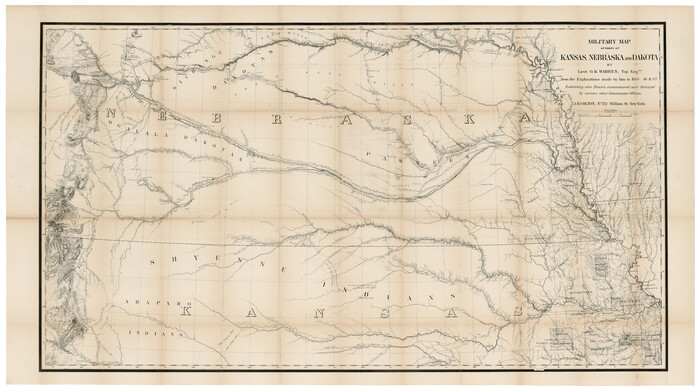
Military Map of parts of Kansas, Nebraska and Dakota by Lieut. G.K. Warren, Top. Engrs. from the Explorations made by him in 1855, 56 & 57 exhibiting also routes reconnouered [sic] and surveyed by various other government officers
Print $20.00
- Digital $50.00
Military Map of parts of Kansas, Nebraska and Dakota by Lieut. G.K. Warren, Top. Engrs. from the Explorations made by him in 1855, 56 & 57 exhibiting also routes reconnouered [sic] and surveyed by various other government officers
Size: 19.9 x 35.6 inches
93995
Mapa de los Estados Unidos de Méjico, Segun lo organizado y definido por las varias actas del Congreso de dicha Republica: y construido por las mejores autoridades

Print $20.00
- Digital $50.00
Mapa de los Estados Unidos de Méjico, Segun lo organizado y definido por las varias actas del Congreso de dicha Republica: y construido por las mejores autoridades
1847
Size: 31.2 x 42.9 inches
93763
Mapa de los Estados Unidos de Méjico, Segun lo organizado y definido por las varias actas del Congreso de dicha Republica: y construido por las mejores autoridades

Print $20.00
- Digital $50.00
Mapa de los Estados Unidos de Méjico, Segun lo organizado y definido por las varias actas del Congreso de dicha Republica: y construido por las mejores autoridades
1828
Size: 30.2 x 42.2 inches
93933
Map of the State of Texas from the latest authorities

Print $20.00
- Digital $50.00
Map of the State of Texas from the latest authorities
1854
Size: 13.2 x 16.3 inches
93761
Map of the River Sabine from its mouth on the Gulf of Mexico in the sea to Logan's Ferry

Print $20.00
- Digital $50.00
Map of the River Sabine from its mouth on the Gulf of Mexico in the sea to Logan's Ferry
1842
Size: 37.5 x 9.4 inches
93767
Map of the River Sabine from Logan's Ferry to 32nd degree of north latitude

Print $3.00
- Digital $50.00
Map of the River Sabine from Logan's Ferry to 32nd degree of north latitude
1842
Size: 8.7 x 11.6 inches
93768
Map of the Oregon Territory by the U.S. Ex. Ex.

Print $20.00
- Digital $50.00
Map of the Oregon Territory by the U.S. Ex. Ex.
1841
Size: 26.2 x 37.3 inches
94060
Map of part of the island of Hawaii Sandwich Islands shewing the craters and eruption of May and June 1840 by the U.S. Ex. Ex.

Print $20.00
- Digital $50.00
Map of part of the island of Hawaii Sandwich Islands shewing the craters and eruption of May and June 1840 by the U.S. Ex. Ex.
1841
Size: 18.4 x 25.9 inches
94061
Map of West Hickory Creek, Venango & Warren Cos., Pa.

Print $20.00
- Digital $50.00
Map of West Hickory Creek, Venango & Warren Cos., Pa.
1866
Size: 45.7 x 24.7 inches
94056
Map of Texas, compiled from surveys on record in the General Land Office of the Republic to the year 1839

Print $20.00
- Digital $50.00
Map of Texas, compiled from surveys on record in the General Land Office of the Republic to the year 1839
1839
Size: 33.1 x 25.8 inches
93986
Map of Texas comprising the grant of the Texian Emigration and Land-Company

Print $20.00
- Digital $50.00
Map of Texas comprising the grant of the Texian Emigration and Land-Company
1843
Size: 9.4 x 10.1 inches
94049
Map of Texas With Parts of the Adjoining States

Print $20.00
- Digital $50.00
Map of Texas With Parts of the Adjoining States
1836
Size: 30.9 x 24.8 inches
93932
Map of Mexico, including Yucatan & Upper California, exhibiting the chief cities and towns, the principal travelling routes &c.

Print $20.00
- Digital $50.00
Map of Mexico, including Yucatan & Upper California, exhibiting the chief cities and towns, the principal travelling routes &c.
1847
Size: 33.5 x 24.7 inches
93936
Map of Arizona prepared specially for R.J. Hinton's handbook of Arizona

Print $20.00
- Digital $50.00
Map of Arizona prepared specially for R.J. Hinton's handbook of Arizona
1877
Size: 36.4 x 25.7 inches
94062
[Rand McNally's Indexed Map of Texas and Indian Territory]
Print $20.00
- Digital $50.00
[Rand McNally's Indexed Map of Texas and Indian Territory]
-
Size
26.0 x 20.6 inches
-
Map/Doc
93992
Traveller's Map of the State of Texas
Print $20.00
- Digital $50.00
Traveller's Map of the State of Texas
1867
-
Size
43.6 x 41.7 inches
-
Map/Doc
93935
-
Creation Date
1867
The Rand-McNally New Commercial Atlas Map of Texas
Print $20.00
- Digital $50.00
The Rand-McNally New Commercial Atlas Map of Texas
-
Size
29.5 x 40.3 inches
-
Map/Doc
93993
Sabine Pass and mouth of the River Sabine in the sea
Print $20.00
- Digital $50.00
Sabine Pass and mouth of the River Sabine in the sea
1842
-
Size
24.0 x 19.1 inches
-
Map/Doc
93766
-
Creation Date
1842
Rand, McNally & Co's New Mexico
Print $20.00
- Digital $50.00
Rand, McNally & Co's New Mexico
1880
-
Size
21.4 x 14.7 inches
-
Map/Doc
94050
-
Creation Date
1880
Plan of the cities of Denver, Auraria and Highland, Jefferson Terr.
Print $20.00
- Digital $50.00
Plan of the cities of Denver, Auraria and Highland, Jefferson Terr.
1859
-
Size
23.7 x 29.8 inches
-
Map/Doc
94053
-
Creation Date
1859
Part of the boundary between the United States and Texas; north of Sabine River, from the 72nd mile mound to the Red River
Print $3.00
- Digital $50.00
Part of the boundary between the United States and Texas; north of Sabine River, from the 72nd mile mound to the Red River
1842
-
Size
12.8 x 8.1 inches
-
Map/Doc
93771
-
Creation Date
1842
Part of the boundary between the United States and Texas; north of Sabine River from the 36th to the 72nd mile mound
Print $3.00
- Digital $50.00
Part of the boundary between the United States and Texas; north of Sabine River from the 36th to the 72nd mile mound
1842
-
Size
12.0 x 8.8 inches
-
Map/Doc
93770
-
Creation Date
1842
Part of the boundary between the United States and Texas; from Sabine River northward to the 36th mile mound
Print $2.00
- Digital $50.00
Part of the boundary between the United States and Texas; from Sabine River northward to the 36th mile mound
1842
-
Size
12.5 x 7.6 inches
-
Map/Doc
93769
-
Creation Date
1842
Outline Map showing a new route from Texas to Fort Yuma, California for cattle droves and trains en route to California
Print $40.00
- Digital $50.00
Outline Map showing a new route from Texas to Fort Yuma, California for cattle droves and trains en route to California
1870
-
Size
17.3 x 52.7 inches
-
Map/Doc
94048
-
Creation Date
1870
Nouvelle carte du Mexique, du Texas et d'une partie des États Limitrophes
Print $20.00
- Digital $50.00
Nouvelle carte du Mexique, du Texas et d'une partie des États Limitrophes
1834
-
Size
39.5 x 27.2 inches
-
Map/Doc
93764
-
Creation Date
1834
New Map of the Mining Regions of Idaho and Montana showing the geographical positions of the Blackfoot, Owyhee & South Boise Mines and the various routes thereto
Print $20.00
- Digital $50.00
New Map of the Mining Regions of Idaho and Montana showing the geographical positions of the Blackfoot, Owyhee & South Boise Mines and the various routes thereto
-
Size
21.9 x 29.4 inches
-
Map/Doc
93991
Nebraska and Kansas
Print $20.00
- Digital $50.00
Nebraska and Kansas
-
Size
14.7 x 16.7 inches
-
Map/Doc
93997
Morley's Map of New Mexico compiled from the latest government surveys and other reliable sources
Print $20.00
- Digital $50.00
Morley's Map of New Mexico compiled from the latest government surveys and other reliable sources
1873
-
Size
26.2 x 28.0 inches
-
Map/Doc
94052
-
Creation Date
1873
Minnesota Route the shortest and best to the Idaho Gold Mines
Print $20.00
- Digital $50.00
Minnesota Route the shortest and best to the Idaho Gold Mines
-
Size
21.0 x 46.3 inches
-
Map/Doc
93989
Military Map of parts of Kansas, Nebraska and Dakota by Lieut. G.K. Warren, Top. Engrs. from the Explorations made by him in 1855, 56 & 57 exhibiting also routes reconnouered [sic] and surveyed by various other government officers
Print $20.00
- Digital $50.00
Military Map of parts of Kansas, Nebraska and Dakota by Lieut. G.K. Warren, Top. Engrs. from the Explorations made by him in 1855, 56 & 57 exhibiting also routes reconnouered [sic] and surveyed by various other government officers
-
Size
19.9 x 35.6 inches
-
Map/Doc
93995
Mapa de los Estados Unidos de Méjico, Segun lo organizado y definido por las varias actas del Congreso de dicha Republica: y construido por las mejores autoridades
Print $20.00
- Digital $50.00
Mapa de los Estados Unidos de Méjico, Segun lo organizado y definido por las varias actas del Congreso de dicha Republica: y construido por las mejores autoridades
1847
-
Size
31.2 x 42.9 inches
-
Map/Doc
93763
-
Creation Date
1847
Mapa de los Estados Unidos de Méjico, Segun lo organizado y definido por las varias actas del Congreso de dicha Republica: y construido por las mejores autoridades
Print $20.00
- Digital $50.00
Mapa de los Estados Unidos de Méjico, Segun lo organizado y definido por las varias actas del Congreso de dicha Republica: y construido por las mejores autoridades
1828
-
Size
30.2 x 42.2 inches
-
Map/Doc
93933
-
Creation Date
1828
Map of the State of Texas from the latest authorities
Print $20.00
- Digital $50.00
Map of the State of Texas from the latest authorities
1854
-
Size
13.2 x 16.3 inches
-
Map/Doc
93761
-
Creation Date
1854
Map of the River Sabine from its mouth on the Gulf of Mexico in the sea to Logan's Ferry
Print $20.00
- Digital $50.00
Map of the River Sabine from its mouth on the Gulf of Mexico in the sea to Logan's Ferry
1842
-
Size
37.5 x 9.4 inches
-
Map/Doc
93767
-
Creation Date
1842
Map of the River Sabine from Logan's Ferry to 32nd degree of north latitude
Print $3.00
- Digital $50.00
Map of the River Sabine from Logan's Ferry to 32nd degree of north latitude
1842
-
Size
8.7 x 11.6 inches
-
Map/Doc
93768
-
Creation Date
1842
Map of the Oregon Territory by the U.S. Ex. Ex.
Print $20.00
- Digital $50.00
Map of the Oregon Territory by the U.S. Ex. Ex.
1841
-
Size
26.2 x 37.3 inches
-
Map/Doc
94060
-
Creation Date
1841
Map of part of the island of Hawaii Sandwich Islands shewing the craters and eruption of May and June 1840 by the U.S. Ex. Ex.
Print $20.00
- Digital $50.00
Map of part of the island of Hawaii Sandwich Islands shewing the craters and eruption of May and June 1840 by the U.S. Ex. Ex.
1841
-
Size
18.4 x 25.9 inches
-
Map/Doc
94061
-
Creation Date
1841
Map of West Hickory Creek, Venango & Warren Cos., Pa.
Print $20.00
- Digital $50.00
Map of West Hickory Creek, Venango & Warren Cos., Pa.
1866
-
Size
45.7 x 24.7 inches
-
Map/Doc
94056
-
Creation Date
1866
Map of Texas, compiled from surveys on record in the General Land Office of the Republic to the year 1839
Print $20.00
- Digital $50.00
Map of Texas, compiled from surveys on record in the General Land Office of the Republic to the year 1839
1839
-
Size
33.1 x 25.8 inches
-
Map/Doc
93986
-
Creation Date
1839
Map of Texas comprising the grant of the Texian Emigration and Land-Company
Print $20.00
- Digital $50.00
Map of Texas comprising the grant of the Texian Emigration and Land-Company
1843
-
Size
9.4 x 10.1 inches
-
Map/Doc
94049
-
Creation Date
1843
Map of Texas With Parts of the Adjoining States
Print $20.00
- Digital $50.00
Map of Texas With Parts of the Adjoining States
1836
-
Size
30.9 x 24.8 inches
-
Map/Doc
93932
-
Creation Date
1836
Map of Mexico, including Yucatan & Upper California, exhibiting the chief cities and towns, the principal travelling routes &c.
Print $20.00
- Digital $50.00
Map of Mexico, including Yucatan & Upper California, exhibiting the chief cities and towns, the principal travelling routes &c.
1847
-
Size
33.5 x 24.7 inches
-
Map/Doc
93936
-
Creation Date
1847
Map of Arizona prepared specially for R.J. Hinton's handbook of Arizona
Print $20.00
- Digital $50.00
Map of Arizona prepared specially for R.J. Hinton's handbook of Arizona
1877
-
Size
36.4 x 25.7 inches
-
Map/Doc
94062
-
Creation Date
1877