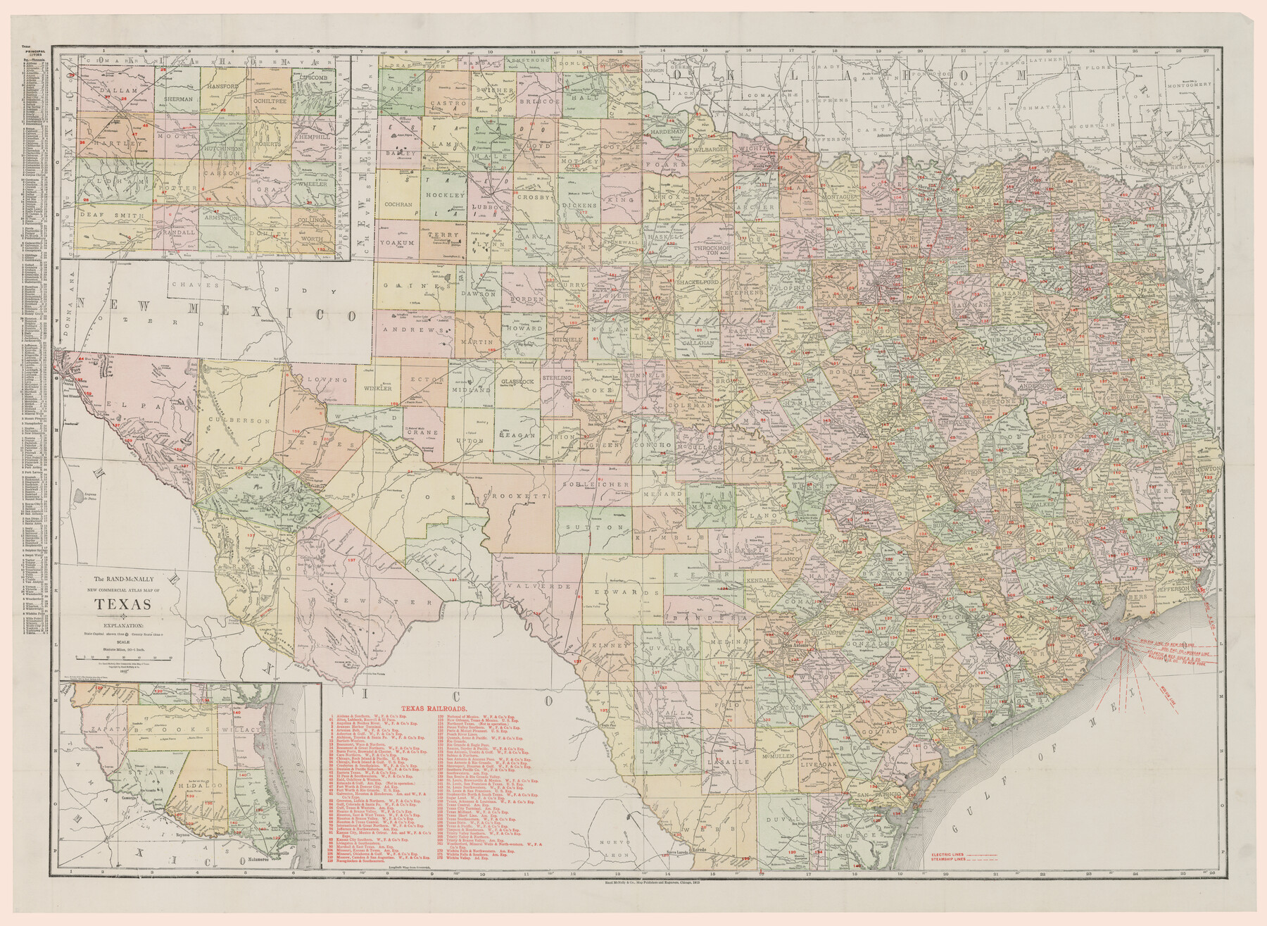
The Rand-McNally New Commercial Atlas Map of Texas
-
Map/Doc
93993
-
Collection
Rees-Jones Digital Map Collection
-
People and Organizations
Rand McNally & Co. (Publisher)
Rand McNally & Co. (Printer)
-
Subjects
Atlas Railroads State of Texas
-
Height x Width
29.5 x 40.3 inches
74.9 x 102.4 cm
-
Medium
paper
-
Comments
From Rand McNally & Co's New Business Atlas Map of Texas. Courtesy of the Rees-Jones Collection, Dallas, TX.
Related maps
The Rand-McNally New Commercial Atlas Map of Texas

The Rand-McNally New Commercial Atlas Map of Texas
1914
Size 29.4 x 40.7 inches
Map/Doc 88745
Part of: Rees-Jones Digital Map Collection
A new map of the states of Texas & California, the territories of Oregon, New Mexico, Utah, and the regions adjacent: compiled from the most recent authorities

Print $20.00
- Digital $50.00
A new map of the states of Texas & California, the territories of Oregon, New Mexico, Utah, and the regions adjacent: compiled from the most recent authorities
1851
Size 22.4 x 20.4 inches
Map/Doc 94051
Map of Texas comprising the grant of the Texian Emigration and Land-Company

Print $20.00
- Digital $50.00
Map of Texas comprising the grant of the Texian Emigration and Land-Company
1843
Size 9.4 x 10.1 inches
Map/Doc 94049
A New Map of Texas, Oregon and California with the regions adjoining, compiled from the most recent authorities

Print $20.00
- Digital $50.00
A New Map of Texas, Oregon and California with the regions adjoining, compiled from the most recent authorities
Size 22.8 x 20.9 inches
Map/Doc 93990
J. De Cordova's Map of the State of Texas Compiled from the records of the General Land Office of the State

Print $20.00
- Digital $50.00
J. De Cordova's Map of the State of Texas Compiled from the records of the General Land Office of the State
1861
Size 36.9 x 34.9 inches
Map/Doc 93931
Map of the River Sabine from its mouth on the Gulf of Mexico in the sea to Logan's Ferry

Print $20.00
- Digital $50.00
Map of the River Sabine from its mouth on the Gulf of Mexico in the sea to Logan's Ferry
1842
Size 37.5 x 9.4 inches
Map/Doc 93767
Military Map of parts of Kansas, Nebraska and Dakota by Lieut. G.K. Warren, Top. Engrs. from the Explorations made by him in 1855, 56 & 57 exhibiting also routes reconnouered [sic] and surveyed by various other government officers
![93995, Military Map of parts of Kansas, Nebraska and Dakota by Lieut. G.K. Warren, Top. Engrs. from the Explorations made by him in 1855, 56 & 57 exhibiting also routes reconnouered [sic] and surveyed by various other government officers, Rees-Jones Digital Map Collection](https://historictexasmaps.com/wmedia_w700/maps/93995-1.tif.jpg)
Print $20.00
- Digital $50.00
Military Map of parts of Kansas, Nebraska and Dakota by Lieut. G.K. Warren, Top. Engrs. from the Explorations made by him in 1855, 56 & 57 exhibiting also routes reconnouered [sic] and surveyed by various other government officers
Size 19.9 x 35.6 inches
Map/Doc 93995
Geological map of the State of Pennsylvania constructed from original surveys

Print $40.00
- Digital $50.00
Geological map of the State of Pennsylvania constructed from original surveys
1858
Size 39.3 x 71.6 inches
Map/Doc 93772
The Rand-McNally New Commercial Atlas Map of Texas

Print $20.00
- Digital $50.00
The Rand-McNally New Commercial Atlas Map of Texas
Size 29.5 x 40.3 inches
Map/Doc 93993
Part of the boundary between the United States and Texas; north of Sabine River from the 36th to the 72nd mile mound

Print $3.00
- Digital $50.00
Part of the boundary between the United States and Texas; north of Sabine River from the 36th to the 72nd mile mound
1842
Size 12.0 x 8.8 inches
Map/Doc 93770
Map of the River Sabine from Logan's Ferry to 32nd degree of north latitude

Print $3.00
- Digital $50.00
Map of the River Sabine from Logan's Ferry to 32nd degree of north latitude
1842
Size 8.7 x 11.6 inches
Map/Doc 93768
A New Map of Nebraska, Kansas, New Mexico and Indian Territories

Print $20.00
- Digital $50.00
A New Map of Nebraska, Kansas, New Mexico and Indian Territories
Size 18.6 x 15.2 inches
Map/Doc 93985

You may also like
Map of Texas. The Proposed Reoccupation of the Rio Grande -- Its Importance to the Union

Print $20.00
Map of Texas. The Proposed Reoccupation of the Rio Grande -- Its Importance to the Union
1965
Size 14.1 x 8.6 inches
Map/Doc 76264
Armstrong County

Print $20.00
- Digital $50.00
Armstrong County
1879
Size 21.6 x 19.2 inches
Map/Doc 3242

Atascosa County Rolled Sketch 5

Print $20.00
- Digital $50.00
Atascosa County Rolled Sketch 5
1910
Size 22.1 x 15.8 inches
Map/Doc 5088
Fannin County Working Sketch 5

Print $20.00
- Digital $50.00
Fannin County Working Sketch 5
1939
Size 11.2 x 18.1 inches
Map/Doc 69159
Dickens County Working Sketch 1

Print $20.00
- Digital $50.00
Dickens County Working Sketch 1
Size 15.5 x 15.5 inches
Map/Doc 68648
Hood County Sketch File 9

Print $26.00
- Digital $50.00
Hood County Sketch File 9
1859
Size 9.6 x 4.5 inches
Map/Doc 26586
Panola County Sketch File 28

Print $20.00
- Digital $50.00
Panola County Sketch File 28
1859
Size 22.8 x 22.2 inches
Map/Doc 12142
San Patricio County Rolled Sketch 43

Print $1233.00
- Digital $50.00
San Patricio County Rolled Sketch 43
Size 8.8 x 14.2 inches
Map/Doc 41814
Township 11 North Range 15 West, Western District, Louisiana

Print $20.00
- Digital $50.00
Township 11 North Range 15 West, Western District, Louisiana
1834
Size 19.7 x 24.6 inches
Map/Doc 65870
San Patricio County Sketch File 33

Print $20.00
- Digital $50.00
San Patricio County Sketch File 33
1946
Size 15.5 x 31.0 inches
Map/Doc 12288
Controlled Mosaic by Jack Amman Photogrammetric Engineers, Inc - Sheet 51

Print $20.00
- Digital $50.00
Controlled Mosaic by Jack Amman Photogrammetric Engineers, Inc - Sheet 51
1954
Size 20.0 x 24.0 inches
Map/Doc 83510