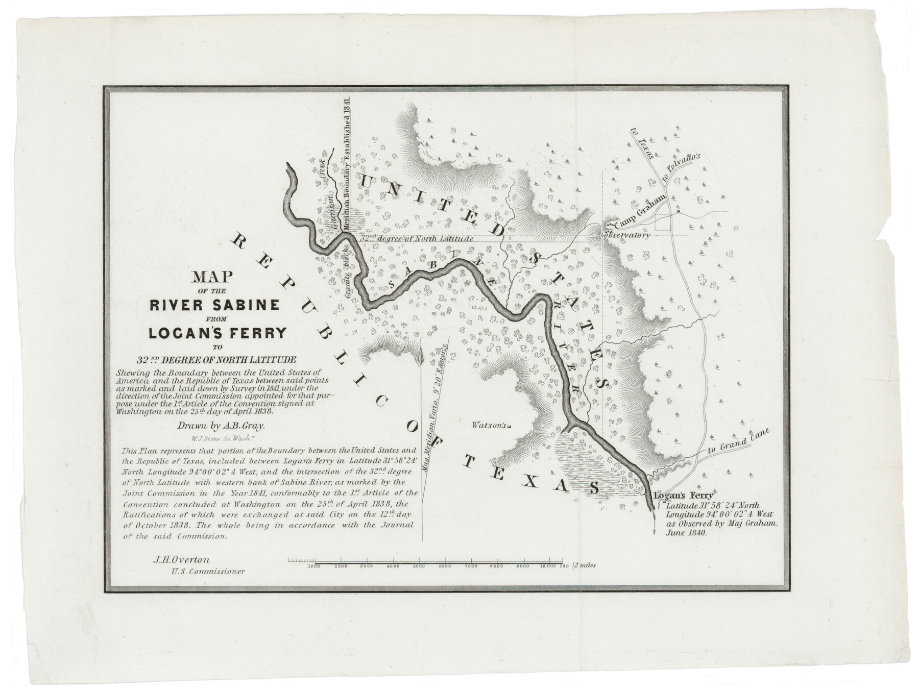
Map of the River Sabine from Logan's Ferry to 32nd degree of north latitude
-
Map/Doc
93768
-
Collection
Rees-Jones Digital Map Collection
-
Object Dates
1842 (Creation Date)
-
People and Organizations
A.B. Gray (Draftsman)
-
Subjects
River Surveys Texas Boundaries
-
Height x Width
8.7 x 11.6 inches
22.1 x 29.5 cm
-
Comments
Courtesy of the Rees-Jones Collection, Dallas, TX
Part of: Rees-Jones Digital Map Collection
Colton's Map of United States, the Canadas & c. showing the Railraods, Canals & Stage Roads with distances from place to place

Print $20.00
- Digital $50.00
Colton's Map of United States, the Canadas & c. showing the Railraods, Canals & Stage Roads with distances from place to place
Size 28.8 x 33.0 inches
Map/Doc 93983
A Map of the United States of Mexico as organized and defined by the several Acts of the Congress of that Republic

Print $20.00
- Digital $50.00
A Map of the United States of Mexico as organized and defined by the several Acts of the Congress of that Republic
1846
Size 24.0 x 31.7 inches
Map/Doc 93760
Outline Map showing a new route from Texas to Fort Yuma, California for cattle droves and trains en route to California

Print $40.00
- Digital $50.00
Outline Map showing a new route from Texas to Fort Yuma, California for cattle droves and trains en route to California
1870
Size 17.3 x 52.7 inches
Map/Doc 94048
Minnesota Route the shortest and best to the Idaho Gold Mines

Print $20.00
- Digital $50.00
Minnesota Route the shortest and best to the Idaho Gold Mines
Size 21.0 x 46.3 inches
Map/Doc 93989
Guide map of the Great Texas Cattle Trail from Red River crossing to the Old Reliable Kansas Pacific Railway

Print $20.00
- Digital $50.00
Guide map of the Great Texas Cattle Trail from Red River crossing to the Old Reliable Kansas Pacific Railway
1873
Size 23.4 x 17.6 inches
Map/Doc 93938
J. De Cordova's Map of the State of Texas Compiled from the records of the General Land Office of the State

Print $20.00
- Digital $50.00
J. De Cordova's Map of the State of Texas Compiled from the records of the General Land Office of the State
1849
Size 36.0 x 34.0 inches
Map/Doc 93930
A new map of Texas, Oregon and California with the regions adjoining, compiled from the most recent authorities

Print $20.00
- Digital $50.00
A new map of Texas, Oregon and California with the regions adjoining, compiled from the most recent authorities
1846
Size 23.7 x 21.8 inches
Map/Doc 93940
A new map of the states of Texas & California, the territories of Oregon, New Mexico, Utah, and the regions adjacent: compiled from the most recent authorities

Print $20.00
- Digital $50.00
A new map of the states of Texas & California, the territories of Oregon, New Mexico, Utah, and the regions adjacent: compiled from the most recent authorities
1851
Size 22.4 x 20.4 inches
Map/Doc 94051
The Rand-McNally New Commercial Atlas Map of Texas

Print $20.00
- Digital $50.00
The Rand-McNally New Commercial Atlas Map of Texas
Size 29.5 x 40.3 inches
Map/Doc 93993
Map of Texas With Parts of the Adjoining States

Print $20.00
- Digital $50.00
Map of Texas With Parts of the Adjoining States
1836
Size 30.9 x 24.8 inches
Map/Doc 93932
A New Map of Texas with the Contiguous American & Mexican States

Print $20.00
- Digital $50.00
A New Map of Texas with the Contiguous American & Mexican States
1839
Size 13.5 x 16.1 inches
Map/Doc 93941
J. De Cordova's Map of the State of Texas Compiled from the records of the General Land Office of the State

Print $20.00
- Digital $50.00
J. De Cordova's Map of the State of Texas Compiled from the records of the General Land Office of the State
Size 38.5 x 36.4 inches
Map/Doc 93984
You may also like
Johnson County Sketch File 14

Print $4.00
- Digital $50.00
Johnson County Sketch File 14
1860
Size 12.8 x 8.2 inches
Map/Doc 28450
Leon County Rolled Sketch 15

Print $20.00
- Digital $50.00
Leon County Rolled Sketch 15
1979
Size 23.5 x 18.9 inches
Map/Doc 6601
Map of Block KS in Oldham and Hartley County, Texas

Print $20.00
- Digital $50.00
Map of Block KS in Oldham and Hartley County, Texas
1902
Size 16.7 x 21.5 inches
Map/Doc 90768
Crockett County Working Sketch 57

Print $20.00
- Digital $50.00
Crockett County Working Sketch 57
1954
Size 35.9 x 38.8 inches
Map/Doc 68390
Karnes County Sketch File 10

Print $10.00
- Digital $50.00
Karnes County Sketch File 10
1885
Size 12.8 x 8.5 inches
Map/Doc 28597
Cass County Working Sketch 35

Print $20.00
- Digital $50.00
Cass County Working Sketch 35
1982
Size 23.5 x 44.8 inches
Map/Doc 67938
Crockett County Rolled Sketch 89

Print $20.00
- Digital $50.00
Crockett County Rolled Sketch 89
1974
Size 21.1 x 15.8 inches
Map/Doc 5630
El Paso County Boundary File 6

Print $14.00
- Digital $50.00
El Paso County Boundary File 6
Size 14.0 x 8.8 inches
Map/Doc 53080
Liberty County Working Sketch 71

Print $20.00
- Digital $50.00
Liberty County Working Sketch 71
1977
Size 37.3 x 31.8 inches
Map/Doc 70531
Clay County Sketch File 20

Print $8.00
- Digital $50.00
Clay County Sketch File 20
1882
Size 11.2 x 8.6 inches
Map/Doc 18431
Leon County Working Sketch 3

Print $20.00
- Digital $50.00
Leon County Working Sketch 3
1920
Size 15.9 x 14.4 inches
Map/Doc 70402
[Beaumont, Sour Lake and Western Ry. Right of Way and Alignment - Frisco]
![64112, [Beaumont, Sour Lake and Western Ry. Right of Way and Alignment - Frisco], General Map Collection](https://historictexasmaps.com/wmedia_w700/maps/64112.tif.jpg)
Print $20.00
- Digital $50.00
[Beaumont, Sour Lake and Western Ry. Right of Way and Alignment - Frisco]
1910
Size 20.3 x 46.0 inches
Map/Doc 64112