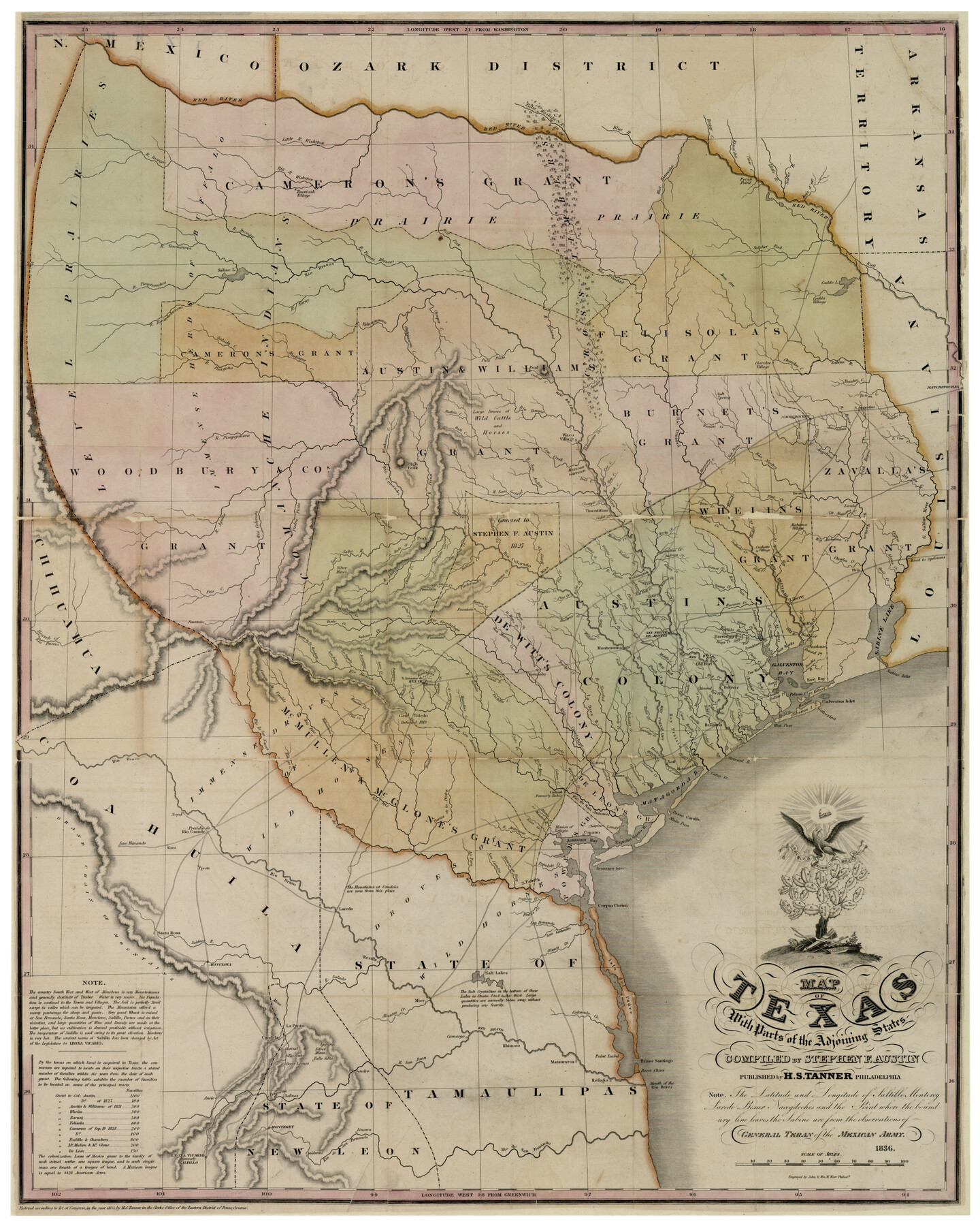
Map of Texas With Parts of the Adjoining States
-
Map/Doc
93932
-
Collection
Rees-Jones Digital Map Collection
-
Object Dates
1836 (Creation Date)
-
People and Organizations
H. S. Tanner (Publisher)
Stephen F. Austin (Author)
-
Subjects
Republic of Texas
-
Height x Width
30.9 x 24.8 inches
78.5 x 63.0 cm
-
Comments
Courtesy of the Rees-Jones Collection, Dallas, TX
Part of: Rees-Jones Digital Map Collection
Military Map of parts of Kansas, Nebraska and Dakota by Lieut. G.K. Warren, Top. Engrs. from the Explorations made by him in 1855, 56 & 57 exhibiting also routes reconnouered [sic] and surveyed by various other government officers
![93995, Military Map of parts of Kansas, Nebraska and Dakota by Lieut. G.K. Warren, Top. Engrs. from the Explorations made by him in 1855, 56 & 57 exhibiting also routes reconnouered [sic] and surveyed by various other government officers, Rees-Jones Digital Map Collection](https://historictexasmaps.com/wmedia_w700/maps/93995-1.tif.jpg)
Print $20.00
- Digital $50.00
Military Map of parts of Kansas, Nebraska and Dakota by Lieut. G.K. Warren, Top. Engrs. from the Explorations made by him in 1855, 56 & 57 exhibiting also routes reconnouered [sic] and surveyed by various other government officers
Size 19.9 x 35.6 inches
Map/Doc 93995
A New Map of the United States upon which are delineated its vast works of internal communication, routes across the continent &c. showing also Canada and the Island of Cuba

Print $20.00
- Digital $50.00
A New Map of the United States upon which are delineated its vast works of internal communication, routes across the continent &c. showing also Canada and the Island of Cuba
Size 25.8 x 30.6 inches
Map/Doc 93996
Map of the Oregon Territory by the U.S. Ex. Ex.

Print $20.00
- Digital $50.00
Map of the Oregon Territory by the U.S. Ex. Ex.
1841
Size 26.2 x 37.3 inches
Map/Doc 94060
Traveller's Map of the State of Texas

Print $20.00
- Digital $50.00
Traveller's Map of the State of Texas
1867
Size 43.6 x 41.7 inches
Map/Doc 93935
A New Map of Texas with the Contiguous American & Mexican States

Print $20.00
- Digital $50.00
A New Map of Texas with the Contiguous American & Mexican States
1839
Size 13.5 x 16.1 inches
Map/Doc 93941
Map of the River Sabine from Logan's Ferry to 32nd degree of north latitude

Print $3.00
- Digital $50.00
Map of the River Sabine from Logan's Ferry to 32nd degree of north latitude
1842
Size 8.7 x 11.6 inches
Map/Doc 93768
Minnesota Route the shortest and best to the Idaho Gold Mines

Print $20.00
- Digital $50.00
Minnesota Route the shortest and best to the Idaho Gold Mines
Size 21.0 x 46.3 inches
Map/Doc 93989
A new map of the states of Texas & California, the territories of Oregon, New Mexico, Utah, and the regions adjacent: compiled from the most recent authorities

Print $20.00
- Digital $50.00
A new map of the states of Texas & California, the territories of Oregon, New Mexico, Utah, and the regions adjacent: compiled from the most recent authorities
1851
Size 22.4 x 20.4 inches
Map/Doc 94051
Map of the State of Texas from the latest authorities

Print $20.00
- Digital $50.00
Map of the State of Texas from the latest authorities
1854
Size 13.2 x 16.3 inches
Map/Doc 93761
Outline Map showing a new route from Texas to Fort Yuma, California for cattle droves and trains en route to California

Print $40.00
- Digital $50.00
Outline Map showing a new route from Texas to Fort Yuma, California for cattle droves and trains en route to California
1870
Size 17.3 x 52.7 inches
Map/Doc 94048
Map of Texas With Parts of the Adjoining States

Print $20.00
- Digital $50.00
Map of Texas With Parts of the Adjoining States
1836
Size 30.9 x 24.8 inches
Map/Doc 93932
A New Map of Nebraska, Kansas, New Mexico and Indian Territories

Print $20.00
- Digital $50.00
A New Map of Nebraska, Kansas, New Mexico and Indian Territories
Size 18.6 x 15.2 inches
Map/Doc 93985
You may also like
Live Oak County

Print $40.00
- Digital $50.00
Live Oak County
1899
Size 52.3 x 38.5 inches
Map/Doc 66905
Flight Mission No. BRA-6M, Frame 73, Jefferson County

Print $20.00
- Digital $50.00
Flight Mission No. BRA-6M, Frame 73, Jefferson County
1953
Size 18.6 x 22.3 inches
Map/Doc 85417
Van Zandt County Sketch File 13

Print $4.00
- Digital $50.00
Van Zandt County Sketch File 13
1858
Size 10.6 x 8.2 inches
Map/Doc 39402
Flight Mission No. BQR-4K, Frame 61, Brazoria County

Print $20.00
- Digital $50.00
Flight Mission No. BQR-4K, Frame 61, Brazoria County
1952
Size 18.7 x 22.5 inches
Map/Doc 83994
Flight Mission No. DCL-5C, Frame 73, Kenedy County

Print $20.00
- Digital $50.00
Flight Mission No. DCL-5C, Frame 73, Kenedy County
1943
Size 18.5 x 22.2 inches
Map/Doc 85856
Tyler County Sketch File A1

Print $22.00
- Digital $50.00
Tyler County Sketch File A1
Size 12.7 x 15.7 inches
Map/Doc 38605
Harris County Sketch File 105

Print $28.00
- Digital $50.00
Harris County Sketch File 105
1925
Size 11.2 x 9.0 inches
Map/Doc 42929

Llano County Working Sketch 12

Print $20.00
- Digital $50.00
Llano County Working Sketch 12
Size 18.8 x 12.5 inches
Map/Doc 70630
Flight Mission No. DQO-8K, Frame 87, Galveston County

Print $20.00
- Digital $50.00
Flight Mission No. DQO-8K, Frame 87, Galveston County
1952
Size 18.6 x 22.4 inches
Map/Doc 85189
Live Oak County Sketch File 30

Print $6.00
- Digital $50.00
Live Oak County Sketch File 30
1925
Size 14.1 x 8.8 inches
Map/Doc 30322
Wilson County

Print $40.00
- Digital $50.00
Wilson County
1921
Size 39.9 x 48.8 inches
Map/Doc 95677